Updated 01.18.21 @ 4:51p
You must be logged in to view this content. Click Here to become a member of IndyWX.com for full access. Already a member of IndyWx.com All-Access? Log-in here.

Jan 18
Updated 01.18.21 @ 4:51p
You must be logged in to view this content. Click Here to become a member of IndyWX.com for full access. Already a member of IndyWx.com All-Access? Log-in here.
Permanent link to this article: https://indywx.com/video-initial-thoughts-on-february-reviewing-the-more-active-weather-pattern-in-front-of-us/
Jan 18

Updated: 01.18.21 @ 8:45a
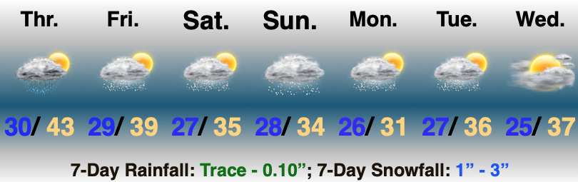
Parade Of Upper Level Disturbances…In what’s been a seemingly unending round of upper level disturbances, we still have 2 more to deal with before we can welcome in high pressure to allow a brief window of quieter weather by late week.
After a mostly cloudy day with a few flurries, a more organized band of snow will roll into south-central Indiana after dark (towards 9p-10p across western areas before overspreading the rest of south-central Indiana) and could deposit a quick inch of snow during the overnight for our friends in Bloomington, Nashville, Seymour, and Columbus. The snow will depart about as quickly as it arrives and will be “outta here” before sunrise Tuesday.
One last upper level feature will race through the state Tuesday evening and early Wednesday with yet another round of scattered snow showers (dusting level stuff).
We’ll then welcome in a cold front Thursday evening and early Friday morning (one of those days where the high will likely come at midnight). The frontal passage will be a dry one, but we’ll notice an uptick in gusty northerly winds during the day Friday. High pressure will then center itself over the Ohio Valley Saturday with a return of sunshine. It’ll be cold though!
A more organized storm will lift northeast into the Ohio Valley by the 2nd half of the weekend. From this distance it appears as if it’ll be one of those “wintry mix to rain” scenarios. More on this and the overall pattern to close the month later today in our Client video update!
Permanent link to this article: https://indywx.com/01-18-21-weather-bulletin-weak-upper-level-disturbances-bigger-storm-system-late-weekend/
Jan 17
Updated 01.17.21 @ 10:00a
You must be logged in to view this content. Click Here to become a member of IndyWX.com for full access. Already a member of IndyWx.com All-Access? Log-in here.
Permanent link to this article: https://indywx.com/video-tracking-3-additional-upper-level-disturbances-to-open-the-week-looking-ahead-to-next-weekend/
Jan 14
Updated 01.14.21 @ 6:52p
You must be logged in to view this content. Click Here to become a member of IndyWX.com for full access. Already a member of IndyWx.com All-Access? Log-in here.
Permanent link to this article: https://indywx.com/video-short-and-long-range-update-as-we-head-into-at-times-a-snowy-weekend-and-get-set-to-traverse-the-2nd-half-of-jan-open-feb/
Jan 14
Updated: 01.14.21 @ 7:47a
One More Relatively Mild Day…A southwesterly air flow will combine with just enough early sun to help boost temperatures into the 40s for one more day. Enjoy as colder air arrives to close the week!
A cold front will pass through the state tonight. A broken band of showers will accompany the frontal passage later this evening. Light will be the key word (0.10″ or less). As colder air filters into central Indiana, scattered snow showers will develop by Friday morning.
Things begin to turn more interesting Friday afternoon as the upper level low pressure system drops south and individual spokes of energy ride into central Indiana. As this takes place, the combination of very cold air aloft and just enough instability (byproduct of daytime heating- yes even this time of year) will warrant conditions that should help heavier and more intense snow bursts (or squalls) develop. While we’re not talking about widespread heavy snow accumulation, these squalls will be intense enough to impact travel throughout the region when encountered. Please plan accordingly and give yourself extra drive time tomorrow afternoon/ evening if you have travel plans. Once the sun sets, the snow squall activity will quickly diminish in coverage and intensity.
Additional periods of light snow can be expected throughout the weekend as individual upper level disturbances cross through the area. At this time, Sunday appears to offer up the best chance of more widespread, organized light snow. We’ll also need to keep an eye to our northwest for one more trailing feature Monday PM into Tuesday (the “caboose,” if you will, in the seemingly unending weekend train of upper level disturbances).
By the middle part of next week, we’ll be able to catch our breath and await the potential of a bigger, moisture-laden storm system impacting the area late next week…
Make it a great Thursday! We’ll be back later this evening with an updated video discussion focused on the long range…
Permanent link to this article: https://indywx.com/01-14-21-weather-bulletin-wintry-conditions-return-for-the-weekend/