Updated 01.23.21 @ 9:10a
You must be logged in to view this content. Click Here to become a member of IndyWX.com for full access. Already a member of IndyWx.com All-Access? Log-in here.

Jan 23
Updated 01.23.21 @ 9:10a
You must be logged in to view this content. Click Here to become a member of IndyWX.com for full access. Already a member of IndyWx.com All-Access? Log-in here.
Permanent link to this article: https://indywx.com/video-cold-sunshine-today-messy-week-ahead/
Jan 22

Updated 01.22.21 @ 9:20a
Focus Is On Next Week…The 1st half of the weekend is easy as high pressure builds into the area, supplying a fresh batch of cold, dry air. Enjoy the sun while you’ve got it. (Don’t anticipate much in the vitamin D department next week). Saturday morning will be very cold (middle 10s for most with single digit ‘chills).
Clouds will thicken up Saturday PM and an initial wave of moisture will arrive into central Indiana Sunday morning. This lead wave of precipitation should be on the light side but with cold air in place, it’ll likely fall as a wintry mix of sleet and potentially freezing rain across the southern half of the state. Where the cold air is a little deeper further north, the predominant precipitation type should take on the form of light snow Sunday morning.
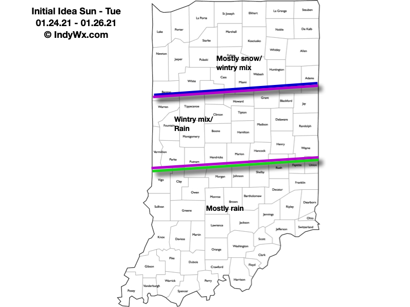
After a potential “lull” Sunday evening, another slug of moisture is inbound Sunday night and Monday. As surface low pressure tracks along the Ohio River during this time frame, this round of precipitation will be heavier and more organized. While this will still require fine tuning, our initial thinking is the form of precipitation will likely fall as the frozen variety across the northern 1/3 of the state with more mixing across immediate central Indiana, and predominantly liquid downstate. We’ll keep a very close eye on the data throughout the weekend, but our initial idea can be found below. Where the precipitation type is predominantly snow, this should be a “plowable” event. Stay tuned.
We’ll have to track another feature by the middle of next week. This could, too, deposit additional wintry conditions across the region, but we need to get through the lead system before trying to get too cute with the mid week feature.
Permanent link to this article: https://indywx.com/01-22-21-weather-bulletin-cold-weekend-messy-open-to-the-new-week-ahead/
Jan 21
Updated 01.21.21 @ 8:00a
You must be logged in to view this content. Click Here to become a member of IndyWX.com for full access. Already a member of IndyWx.com All-Access? Log-in here.
Permanent link to this article: https://indywx.com/video-detailed-breakdown-of-our-latest-thoughts-concerning-next-week/
Jan 20
Updated 01.20.21 @ 7:45a
You must be logged in to view this content. Click Here to become a member of IndyWX.com for full access. Already a member of IndyWx.com All-Access? Log-in here.
Permanent link to this article: https://indywx.com/video-and-the-squeeze-play-is-on/
Jan 19
Updated 01.19.21 @ 7:58a
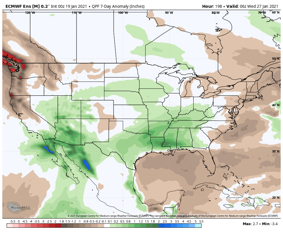
Another upper level disturbance will push into Indiana this evening, providing a renewed shot of snow showers after dark, continuing into the overnight hours. Before we look at this and other storm dates of interest, I wanted to review the upcoming couple of weeks from a temperature and precipitation perspective.
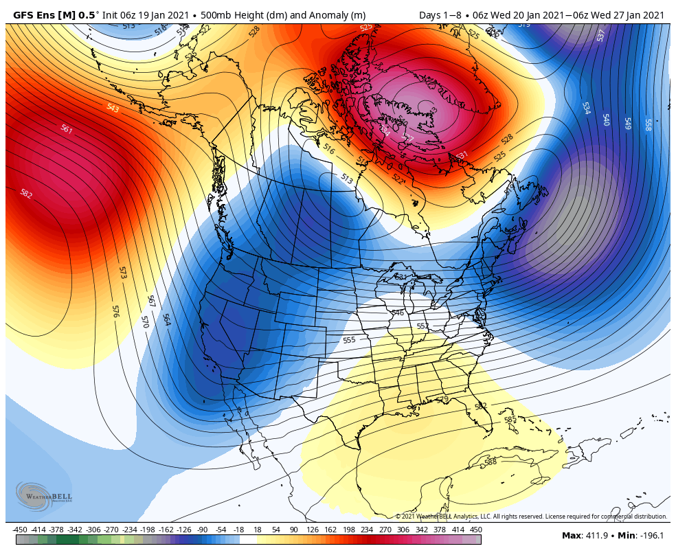
While there weren’t a lot of changes overnight with respect to the ensemble guidance from Week 1 to Week 2, it’s fair to say the GEFS and EPS are trending in 2 separate directions- at least across the Ohio Valley into the Northeast Week 2. The theory here is that the differences come from the way the modeling handles the EPO and subsequent downstream ridge resistance. At any rate, confidence remains lower than normal in the 7-14 day period and it’ll likely take another 48-72 hours for things to become clearer during this time frame.
Week 1
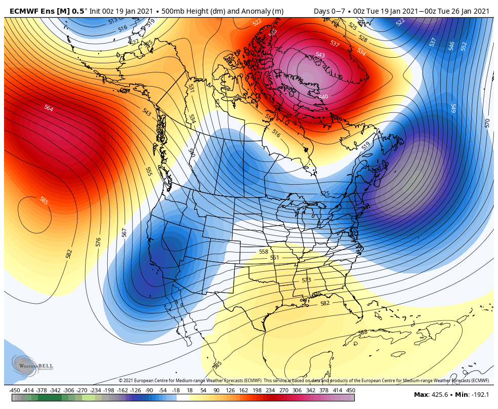

I would lean more on the European in the Week 1 timeframe (due to the precipitation pattern with forecasted trough/ ridge positions), though the solutions are similar, overall.
Week 2
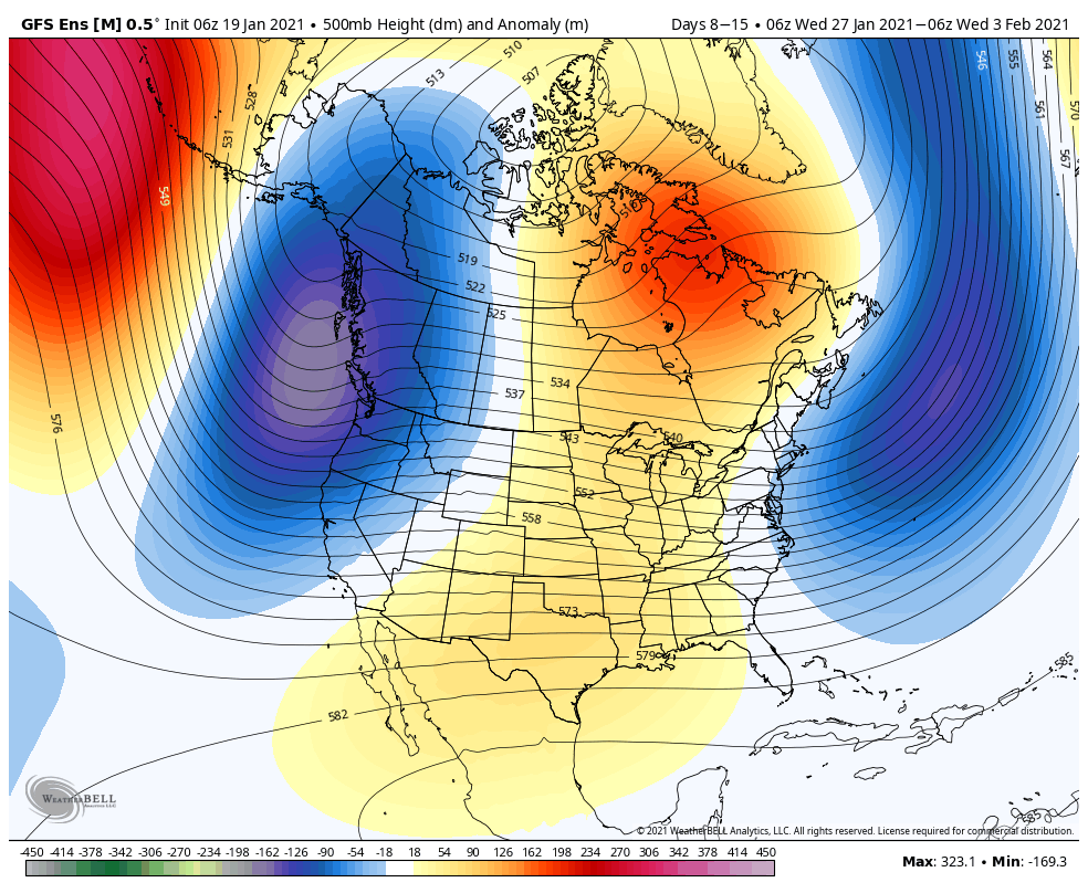


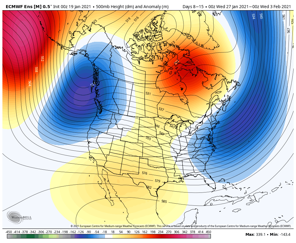

Despite the subtle differences, I would lean heavier towards the European solution again (retrograding eastern trough idea).
Storm dates of note include the following:
Jan. 24th-25th
Jan. 27th-28th
Jan. 31st-Feb. 1st
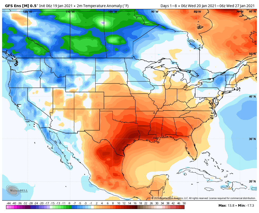
Expect continued wild run-to-run swings on the operational guidance as the data tries to understand the battle between the high latitude blocking (courtesy of the negative AO) and maturing negative PNA (will lead to southern ridging and more resistance as this gets established). These combined ingredients will lead to more of a question of wet vs. white, as opposed to a non-storm “event” that we’re dealing with Thursday-Friday. With the blocking in place, it’ll be tough to drive lows to the Great Lakes and we’ll need to watch for southward trends on guidance the closer we get to these potential storm dates of note above.
In the meantime, we have one more clipper system that will dive into the region this evening. This will offer up yet another round (the last in the series going back to last week) of snow showers after dark into early Wednesday (snow should be out of here by mid to late morning tomorrow). Snowfall accumulations across central Indiana can be expected to fall within the dusting to half inch range.

Permanent link to this article: https://indywx.com/active-pattern-persists-to-close-january-targeting-storm-dates/