Updated 07.14.21 @ 7:15a
You must be logged in to view this content. Click Here to become a member of IndyWX.com for full access. Already a member of IndyWx.com All-Access? Log-in here.

Jul 14
Updated 07.14.21 @ 7:15a
You must be logged in to view this content. Click Here to become a member of IndyWX.com for full access. Already a member of IndyWx.com All-Access? Log-in here.
Permanent link to this article: https://indywx.com/video-changes-on-the-horizon-next-week/
Jul 07
Updated 07.07.21 @ 9:28a
You must be logged in to view this content. Click Here to become a member of IndyWX.com for full access. Already a member of IndyWx.com All-Access? Log-in here.
Permanent link to this article: https://indywx.com/video-afternoon-storms-return-period-of-heavy-weekend-rain/
Jul 05
Updated 07.05.21 @ 9:08a
In case you missed it, our complete July Outlook can be found here.
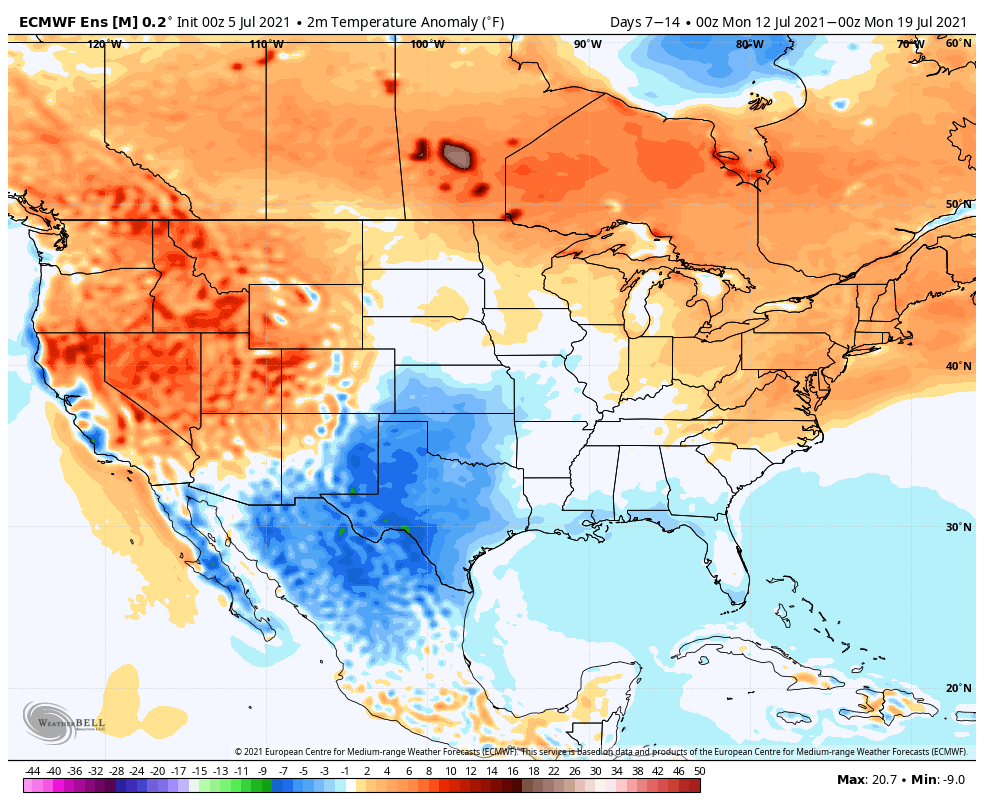
The EPO (big teleconnection “driver” this time of year) is forecast to pop positive in the short-term before heading back negative mid and late month.
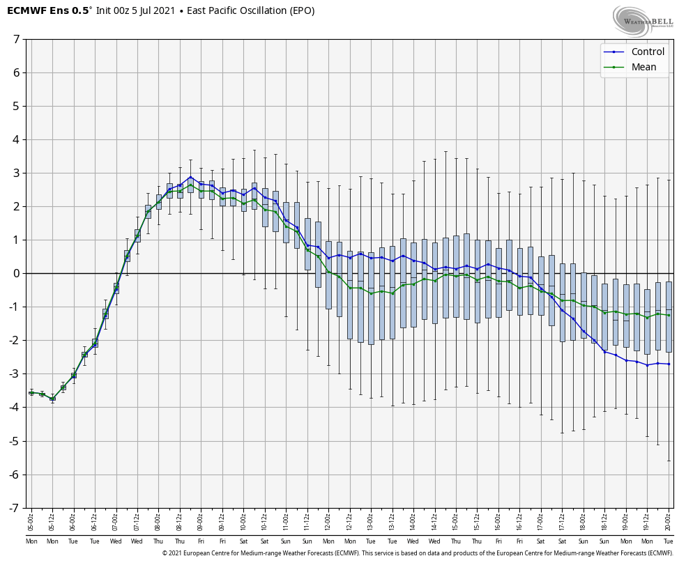
Simply going off of that, one could build a case of warmth returning in the short term but that it would have a hard time sustaining itself. Relative to normals, this has been the story summer-to-date.
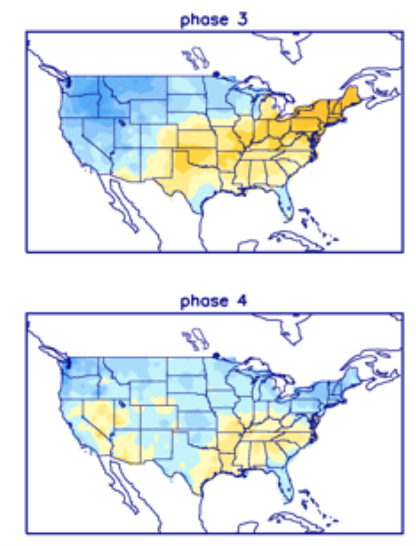
The other key to the longer range pattern has to do with the MJO, or Madden Julian Oscillation.
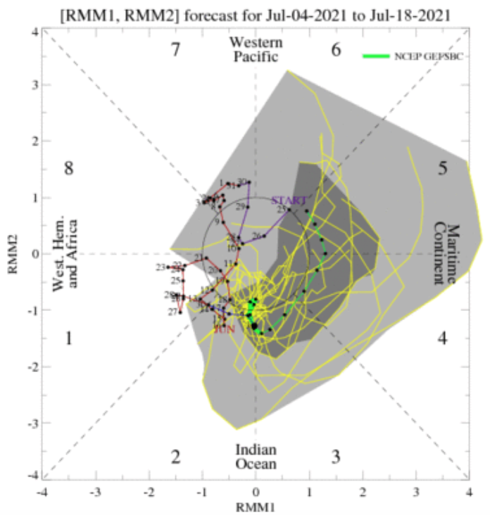
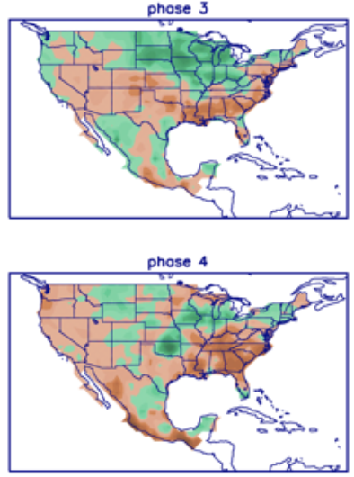
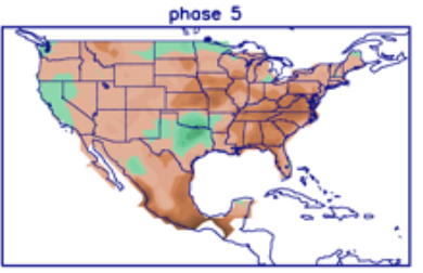
Guidance suggests we’re going to move into Phases 3, 4, and 5 over the coming couple of weeks. The end result would be a continuation of active times (noted from the precipitation correlation below) before drying things out a bit in Phase 5. Similar to what the EPO is perhaps trying to tell us above, sustained heat would be hard to come by, relative to normal. All-in-all, it’s a very transient looking pattern.

When we look at computer model guidance over the next couple of weeks, the upper pattern features a predominant ridge across the West. There’s also more persistent ridging across the Northeast. In between, there’s a “weakness” and tendency for at least more of a “troughy” look in the central.
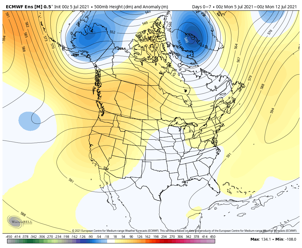

While we’ll have a couple of days here and there of hotter, more humid weather, these conditions won’t have the staying power our friends to our northeast and west will experience. In general, things should balance out very near seasonal levels.
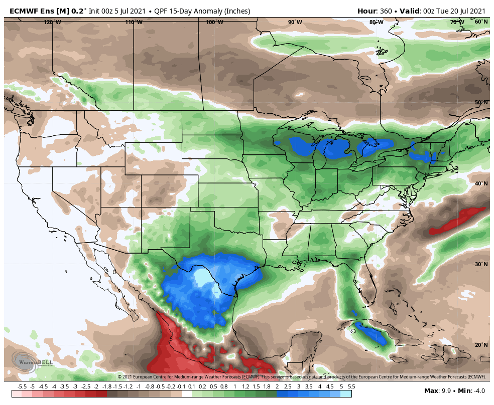
Guidance remains quite bullish on precipitation, painting above normal rainfall through the central and a good chunk of the eastern parts of the country.
Speaking of rain, chances of rain and storms will return Wednesday as our next system approaches. Better chances of more widespread rain can be expected by the weekend. Our video discussions will handle these features and more.
Enjoy your Monday!
Permanent link to this article: https://indywx.com/more-on-the-july-pattern/
Jul 03
Updated 07.03.21 @ 6:46a
You must be logged in to view this content. Click Here to become a member of IndyWX.com for full access. Already a member of IndyWx.com All-Access? Log-in here.
Permanent link to this article: https://indywx.com/video-cant-ask-for-better-weather-for-the-holiday-weekend-timing-out-our-next-rain-chances/
Jul 02
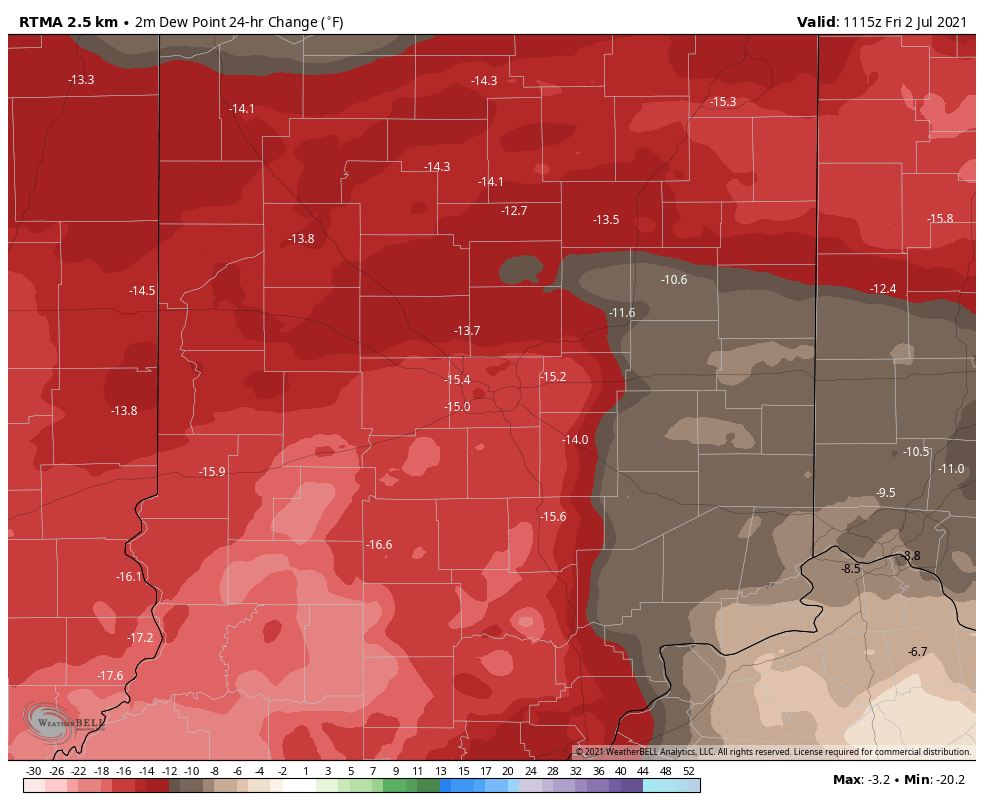
Updated 07.02.21 @ 7:18a
The muggy, tropical airmass that set up shop the better part of the past week is now a thing of the past. Temperatures this morning have fallen into the lower to middle 50s for most of central Indiana (impressive by early July standards) and we’ll likely go a couple of degrees lower than that tomorrow morning. We’ve shaved dew points by 15° to 20° this morning compared to 24 hours ago. Open those windows up and enjoy!
High pressure will dominate our weather through the long holiday weekend, supplying plentiful amounts of sunshine. While the weekend will open cool, temperatures will rebound into the upper 80s for the holiday, itself. Humidity levels will remain low.
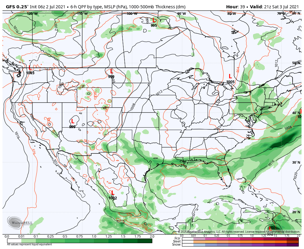
Our next chance of rain won’t arrive until Tuesday afternoon/ evening as a cold front approaches. This front will feature scattered showers and thunderstorms into the day Wednesday (early thinking is 0.50″ to 0.75″ type stuff but we’ll fine tune as we get closer). Another feature I’m sure will catch your attention and that’s Tropical Storm Elsa pegged for the eastern Gulf of Mexico on the latest GFS (been very consistent with this idea). Regardless of Elsa’s eventual track, she won’t be a factor with our weather.
We’ll get back to a drier, cooler airmass next Thursday.
Permanent link to this article: https://indywx.com/sweet-summer-time-pattern-remains-transient-into-mid-july/