Updated 12.30.21 @ 8a
You must be logged in to view this content. Click Here to become a member of IndyWX.com for full access. Already a member of IndyWx.com All-Access? Log-in here.

Dec 30
Updated 12.30.21 @ 8a
You must be logged in to view this content. Click Here to become a member of IndyWX.com for full access. Already a member of IndyWx.com All-Access? Log-in here.
Permanent link to this article: https://indywx.com/video-more-significant-storm-as-we-usher-in-the-new-year-long-range-update/
Dec 29
Updated 12.29.21 @ 8:17a
You must be logged in to view this content. Click Here to become a member of IndyWX.com for full access. Already a member of IndyWx.com All-Access? Log-in here.
Permanent link to this article: https://indywx.com/video-tracking-multiple-systems-in-the-week-ahead/
Dec 27
Updated 12.27.21 @ 4:58p
A busy weather pattern will be with us as we wrap up the year and head into 2022. The first in a seemingly unending series of systems will blow into town Tuesday and feature a period of heavy rain across central Indiana by afternoon, along with a shot of wintry weather for our neighbors across northern Indiana.

Additional (lighter) rain will arrive Wednesday evening. Rain will approach 3/4 of an inch across the greater Indianapolis area and snowfall should span within the 1” to 3” range for most across far northern Indiana Tuesday PM.

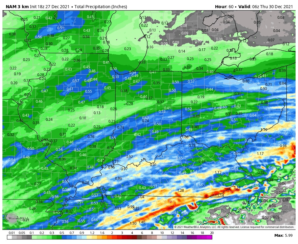

Additional storm systems will roll through here Wednesday night and Thursday and again Friday night and Saturday. The 3rd storm system appears to be the most significant within this batch and should lead to a messy New Year’s Day, including opportunity for additional heavy rain.


For those with travel plans north around New Years, expect the opportunity to encounter more impactful wintry conditions across areas just to our northwest with that system. Early indications suggest this could be a heavy snow maker for areas from the central Plains into the lower Lakes.
On that note, let’s keep close eyes on trailing upper level energy that may lead to a “surprise” second area of snow south with the New Year’s system. This is met with much lower confidence (always is with trailing upper lows in the medium term), but the overall pattern does support the potential of a secondary area of accumulating snow and we’ll keep a close eye on that moving forward. Ohio Valley, TN Valley, or even further east? Anyone’s guess at this point and we’ll continue to closely monitor…
Permanent link to this article: https://indywx.com/busy-pattern-to-close-out-the-year-and-open-2022/
Dec 24
Updated 12.24.21 @ 7:35a
You must be logged in to view this content. Click Here to become a member of IndyWX.com for full access. Already a member of IndyWx.com All-Access? Log-in here.
Permanent link to this article: https://indywx.com/video-busy-short-term-pattern-drivers-behind-the-regime-into-mid-january/
Dec 22
Updated 12.22.21 @ 7:45a
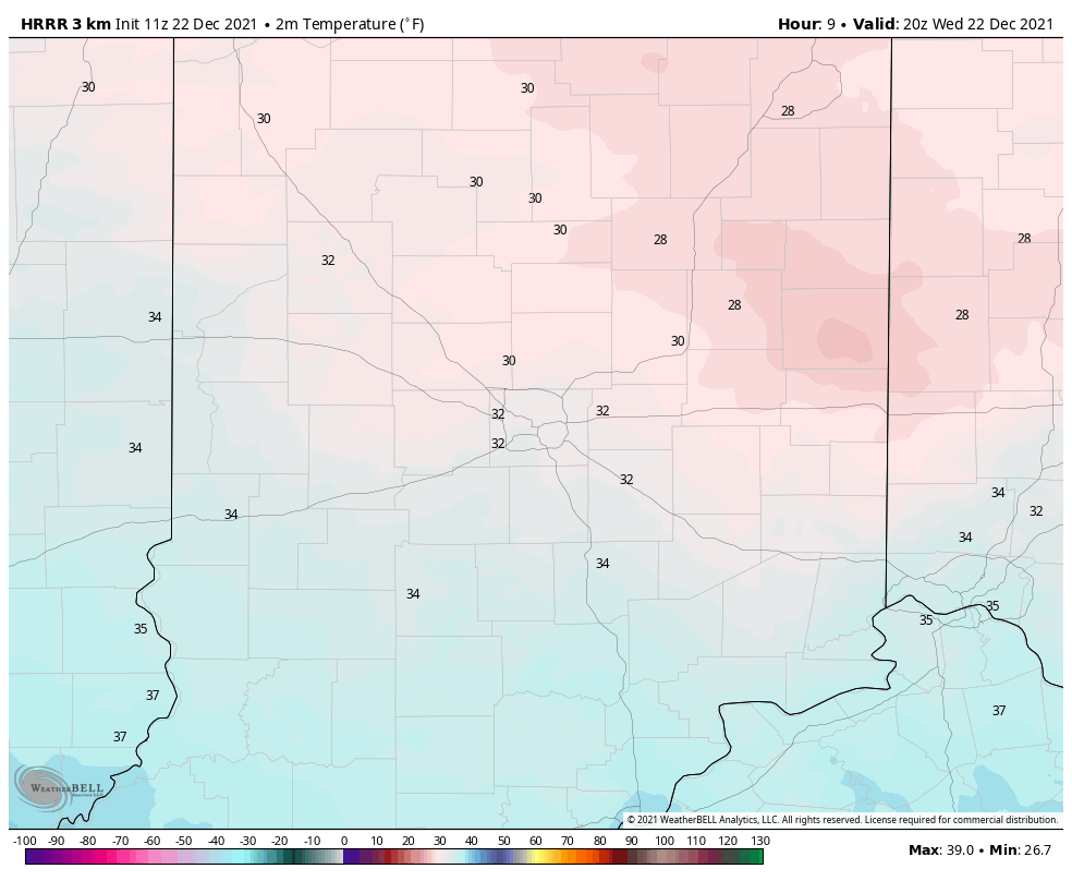
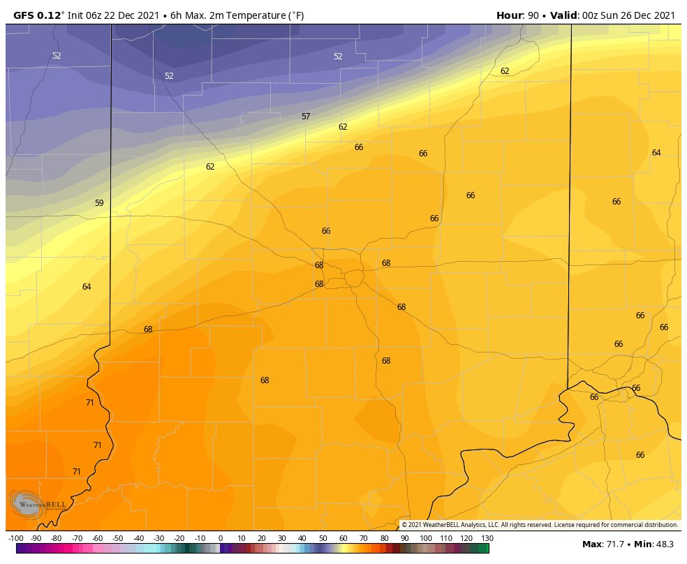
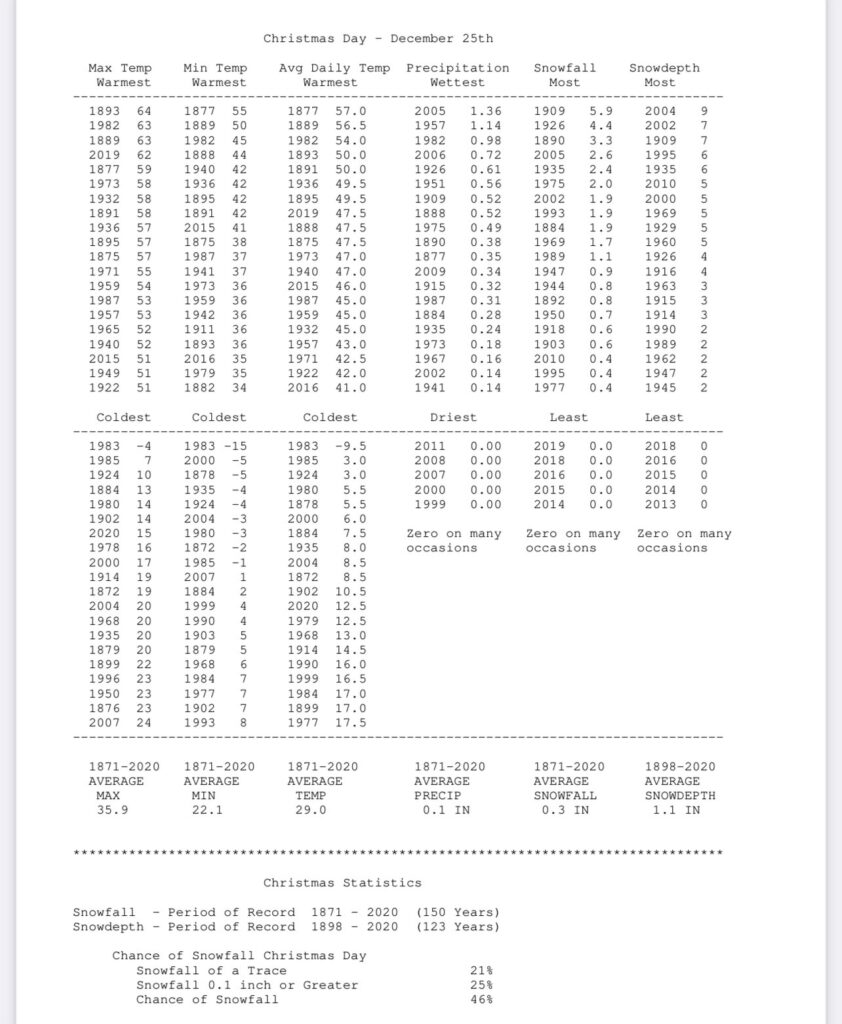
Average temperatures on the 22nd of December include a high of 38.6° and a low of 24.7°. We’ll be slightly under those levels today in what can be termed an “island” of cold in a “sea” of warmth. In fact, the month is running close to 7° above normal thus far.

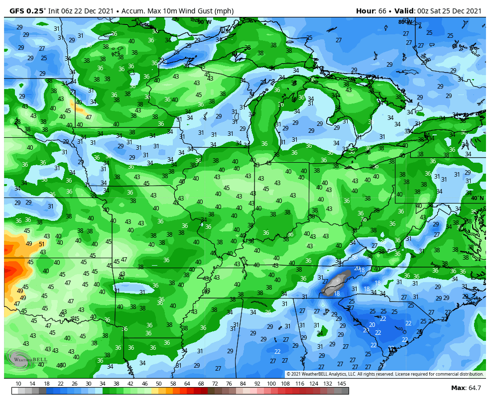
As we look towards the all-important Christmas forecast, quiet weather will carry us into Christmas Eve. That’s when we’ll tighten the pressure gradient and build in southwest gusts of 30 to 40 MPH.
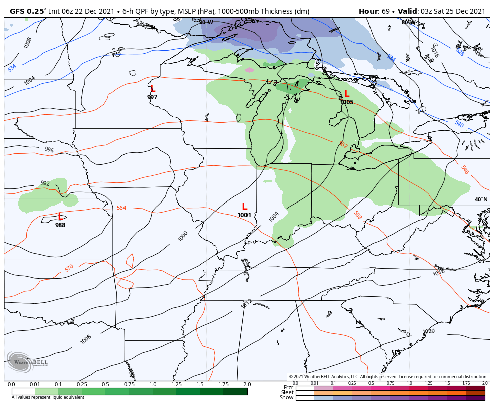
Those southwesterly winds will transport a few scattered light showers into the region Christmas Eve evening into Christmas Day, but these won’t be a big deal. “Scattered” and “light” are the key words.
What will be a big deal are the temperatures. In fact, latest guidance is pointing towards a new record high on Christmas Day. Should we see any sunshine get into the mix, this will be easily achievable.
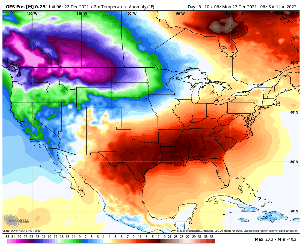
Thereafter, the same general pattern remains intact, locally (- PNA ridge), but notice the cold bleeding into the West between Christmas and New Year’s. Does this eventually make progress east? We think so as we get into January…

Permanent link to this article: https://indywx.com/the-beat-goes-on-and-on-and-on/