Category: Rain

Fresh Batch Of HVY Rain Before Weekend Improvements…

Updated 03.24.23 @ 6:55a

Moderate to heavy rain has been falling through the night across the southern half of Indiana.

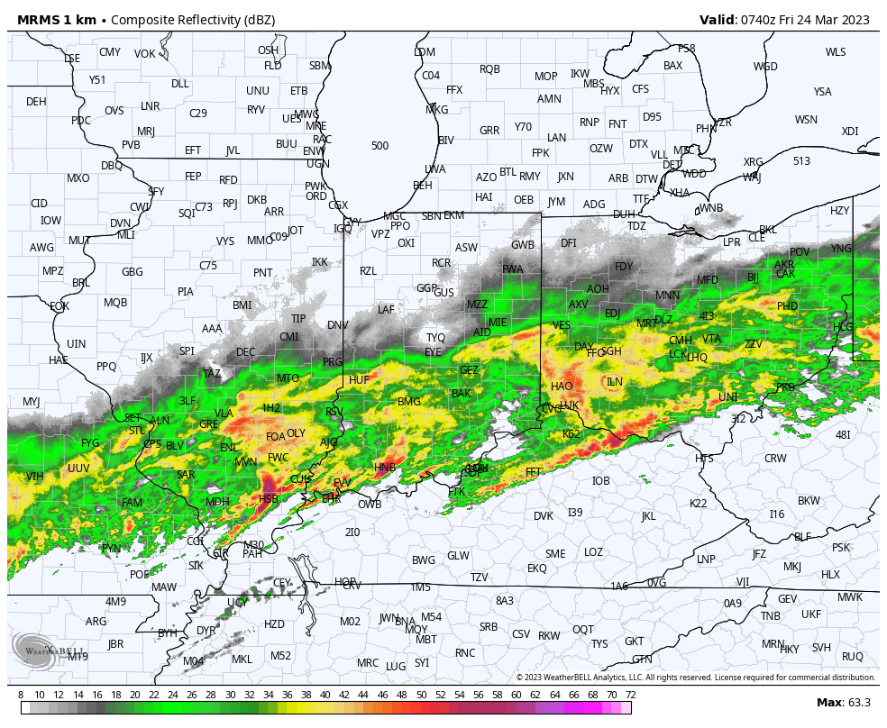
While rain will continue through the daytime downstate, it’s tonight that we’re most concerned around a renewed push of heavy rain that will likely push many creeks and streams into flood stage. This is all associated with a surface low that will lift northeast across the state and into the Great Lakes region. After southern Indiana takes the stage for heaviest rain through the daytime today, all of the region can expect to get in on the heavy rain act tonight. We bracket 11p to 3a for heaviest rain to fall through central Indiana.

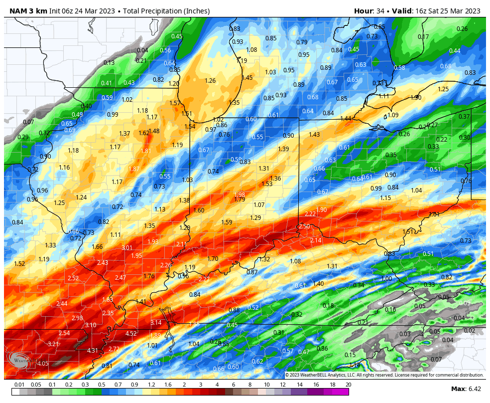
A look at additional rain to come by noon Saturday:

The good news is that after tonight’s heavy rain, weather conditions will improve through the weekend. Our next storm system (much weaker) will arrive Monday but should be fairly moisture starved- certainly compared to our current storm. More on this and a long range look ahead Saturday!

Permanent link to this article: https://indywx.com/fresh-batch-of-hvy-rain-before-weekend-improvements/

Long Range Update To Close Out March And Open April…

Updated 03.17.23 @ 6a

You must be logged in to view this content. Click Here to become a member of IndyWX.com for full access.  Already a member of IndyWx.com All-Access?  Log-in here.

Permanent link to this article: https://indywx.com/long-range-update-to-close-out-march-and-open-april/

VIDEO: Wet, Windy Weather Returns By Evening; Cold Weekend On Tap…

Updated 03.16.23 @ 7:32a

You must be logged in to view this content. Click Here to become a member of IndyWX.com for full access.  Already a member of IndyWx.com All-Access?  Log-in here.

Permanent link to this article: https://indywx.com/video-wet-windy-weather-returns-by-evening-cold-weekend-on-tap/

Unsettled Close To The Work Week; Cold Weekend On Tap…

Updated 03.15.23 @ 6:58a

Let’s start with the good news and that’s today’s forecast. Despite a bitterly cold start (most are waking up to temperatures between 18° and 22°), expect plentiful sunshine today. Though it’ll be unseasonably chilly, that March sun angle will go a long way in making it feel a lot better by this afternoon.

Clouds will increase overnight and Thursday morning and eventually give way to light rain by afternoon. We anticipate rain to reach the city, itself, between 2p and 3p.

Rain will become steadier and more widespread as we progress through the evening and Thursday night.

Precipitation may end as a brief period of snow Friday morning, but “brief” is the key word. In general, heaviest rain is expected to fall across the southern half of the state, mostly along and south of the I-70 corridor. This is a 0.25” to 0.75” type event for most.

The bigger story comes in the form of another late season arctic “jab” behind the frontal passage. Highs both Saturday and Sunday will remain stuck in the 30s with overnight lows once again dropping into the upper 10s to lower 20s. Wind chill values will fall into the single digits to lower 10s.

Permanent link to this article: https://indywx.com/unsettled-close-to-the-work-week-cold-weekend-on-tap/

VIDEO: Cold Air Reinforcements Just In Time For The Weekend…

Updated 03.14.23 @ 6:04a

You must be logged in to view this content. Click Here to become a member of IndyWX.com for full access.  Already a member of IndyWx.com All-Access?  Log-in here.

Permanent link to this article: https://indywx.com/video-cold-air-reinforcements-just-in-time-for-the-weekend/