Updated 11.15.23 @ 7:40a
You must be logged in to view this content. Click Here to become a member of IndyWX.com for full access. Already a member of IndyWx.com All-Access? Log-in here.

Nov 15
Updated 11.15.23 @ 7:40a
You must be logged in to view this content. Click Here to become a member of IndyWX.com for full access. Already a member of IndyWx.com All-Access? Log-in here.
Permanent link to this article: https://indywx.com/video-thanksgiving-forecast-and-a-little-wintry-mischief-to-close-november/
Nov 14
Updated 11.14.23 @ 6:45a
You must be logged in to view this content. Click Here to become a member of IndyWX.com for full access. Already a member of IndyWx.com All-Access? Log-in here.
Permanent link to this article: https://indywx.com/video-colder-late-month-changes/
Nov 13
Updated 11.13.23 @ 1:50p
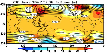
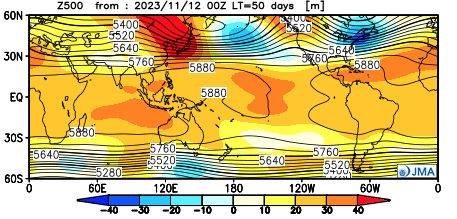
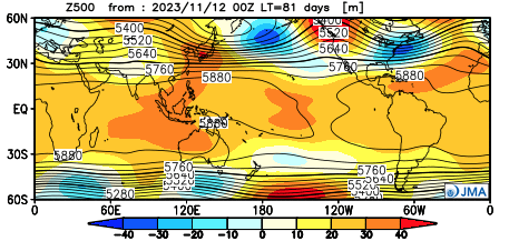
Good afternoon, Clients! As additional seasonal guidance updates, we wanted to take a moment to review the latest trends with you as that data becomes available. Today, the latest JMA monthly product updated and “doubles down” on the idea of an overall mild, but active December morphing into a colder, stormy eastern US regime come January and February. Overall, the model is very consistent from October’s update.
December
Highlights
I. A milder than normal open to meteorological winter, but quite an active pattern on a widespread level- centered Central and Southern tier.
II. Lets keep an eye on the potential of a colder pattern to evolve the last 10 days, or so, of December.
January


Highlights
I. Ridge pulls back into the “sweet spot” and subsequent trough develops across the East. (Would watch for potential of cold to grow more widespread in the next update should this 500mb be accurate, and we think it is).
II. Active Nino southern stream delivers a hectic and busy pattern across the southern tier and up the eastern seaboard. Ripe pattern for eastern winter storm threat(s).
February
Highlights
I. Persistent pattern from January. If anything, ‘mean’ trough/ ridge positions only become that much more prominent. Cold becomes more widespread across the East, compared to January. Again, should the upper air pattern be correct, I’d lean that the model will have to grow colder in time for this period.
II. Very stormy southern and eastern seaboard. Likely multiple attempts at wintry “fun and games,” including deep into the south with this pattern.
Permanent link to this article: https://indywx.com/doubling-down-on-the-winter-idea/
Nov 13
Updated 11.13.23 @ 7:25a It’s not that we’re talking about some sort of major storm (at least not from this distance), but when you factor the difference between this week’s…
You must be logged in to view this content. Click Here to become a member of IndyWX.com for full access. Already a member of IndyWx.com All-Access? Log-in here.
Permanent link to this article: https://indywx.com/video-the-calm-before-the-storm/
Nov 11
Updated 11.11.23 @ 8:15a
There’s no reason to waste pixels on the short-term. High pressure will control our weather through the next 6 days, keeping us dry and providing a moderating trend back into the 60s- after a seasonably chilly weekend.
The next opportunity for precipitation arrives Friday as a cold front provides a quick, glancing blow. Once again, we’re not looking for big impacts either from a temperature or precipitation perspective (0.10” type event). A round of gusty winds will accompany the front, however.
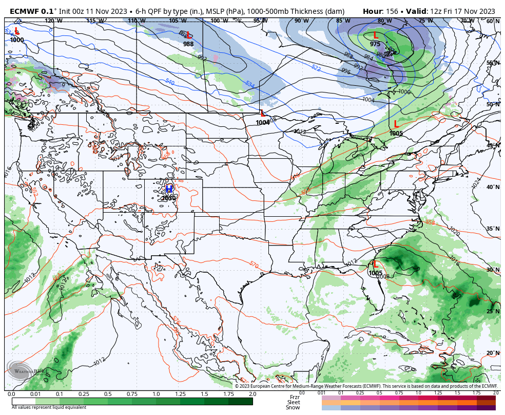
Turning our attention to Thanksgiving week, it continues to look like the pattern will become increasingly busy. Enjoy the quiet time while we have it.
Permanent link to this article: https://indywx.com/easy-peasy-for-now/