Category: PSD

Pleasant Weekend On Deck…

You must be logged in to view this content. Click Here to become a member of IndyWX.com for full access.  Already a member of IndyWx.com All-Access?  Log-in here.

Permanent link to this article: https://indywx.com/2016/07/14/pleasant-weekend-on-deck/

Sunday Weather Rambles…

1.) Indianapolis is running much warmer (+9.1°) and slightly drier than normal (-0.15″) month-to-date.      2.) Snow is flying to our southwest, and accumulating for some in and around St.…

You must be logged in to view this content. Click Here to become a member of IndyWX.com for full access.  Already a member of IndyWx.com All-Access?  Log-in here.

Permanent link to this article: https://indywx.com/2016/03/20/sunday-weather-rambles/

Changeable Monday; Note On Thanksgiving; Warm Open To December…

We wanted to touch on a few items of business this evening.  There’s a lot of weather going on this week…

Monday will feature drastic changes in the weather department across central Indiana:

  • Day starts mild and with lingering showers.
  • Strong and gusty winds will reach speeds of 45-50 MPH.  Batten down the hatches!
  • Temperatures crash late morning into the afternoon.  We start in the lower 50s, but fall to the freezing mark for the drive home across western parts of the state.  Eastern Indiana will see 32 degree air by 7-8 o’clock.
  • Scattered snow showers and flurries will fly across central Indiana Monday evening.

Thanksgiving Cold And Snow:

Temperatures will be much colder than average (low to mid 30s for highs and middle 20s for lows).  We’re still tracking a weak disturbance that could distribute light snow across central Indiana Thanksgiving Day.  Accumulations, if any, would fall in the dusting to less than 1″ range.

Opening December Warm:

We’ve been talking about how this exceptionally cold and wintry early season pattern would have to “relax” at some point and that appears to be the case as we open December.  The potential is there for well above normal warmth for the first week to ten days of December before we reload the pattern and introduce colder, more wintry times for mid and late month (anyone dreaming of a White Christmas)?

B3Kv8sVIEAASt_2

Permanent link to this article: https://indywx.com/2014/11/23/changeable-monday-note-on-thanksgiving-warm-open-to-december/

Tuesday Night Weather Rambles…

It’s hard to believe we’re approaching the July 4th holiday already.  Where is the summer going?!  I remember back in my football days, once past the 4th, summer was over for me as two-a-days began the following week.  Come late July, we would beg for the fall semester of school to begin!  🙂

If you’re like me, the upcoming weather pattern in the days ahead will certainly have you craving fall!  Lows in outlying areas will dip into the upper 40s come Friday morning (not bad for the 4th of July, huh)?  Anyway, here are some things that have the attention of IndyWx.com in the days (and weeks) ahead…

rtma_tmp2m_glus

1.)  Trending Cooler…Note the cooler air in the upper Mid West this evening, including many already in the 50s and 60s.  That cooler air will head south with time Wednesday into Thursday. We’ll note the cooler temperatures tomorrow as highs only reach the middle to upper 70s.  The cooler than normal temperatures will really settle into the region tomorrow night and Thursday, continuing for the big 4th of July holiday.  Some outlying communities may fall into the upper 40s Friday morning!

ir0

2.)  Arthur…What’s now Tropical Storm Arthur will likely continue to strengthen in the days ahead and potentially come too close for comfort to the NC Outer Banks around the upcoming holiday.  By the time Arthur is along (or just offshore) the NC coastline, he may be packing hurricane force winds.  Certainly, plenty of rough seas are to be had up and down the mid Atlantic coast into the Northeast coastal waters for the upcoming long holiday weekend.

z500_anom_f216_ussm


3.)  Continued Active Pattern…Though we’ll enjoy some much needed dry weather as we cool things down, an active time of things will return early next week, including multiple storm chances.

Additionally, we don’t forecast any sort of significant heat for the foreseeable future.  In fact, we may “enjoy” another round of unseasonably cool air by the middle to latter parts of next week, as projected by the ESRL/PSD upper air pattern above.

ssta.glob.DJF2015.1jun2014

4.)  Thoughts Turning To Fall & Winter…Part of what we provide here are thoughts on the seasonal and long range, including a variety of model data that may argue for, and against, our seasonal ideas (have to keep an open mind and be sure not to “model hug” any sort of data set).  The latest JAMSTEC ideas have to make those eastern winter lovers smile…

As we transition from fall to winter, the model suggests a weak, to borderline moderate, El Nino progresses into a Modoki ENSO event (read more HERE about the differences between an El Nino event and an El Nino Modoki event).  Combine this with the warmer than normal north-central and northeastern PAC waters and the players are, at least, on the field for a colder than average east- particularly southeast.

temp2.glob.DJF2015.1jun2014

Pure speculation at this point, and it should be pointed out that this model struggled on the cold winter last year at this time.  Instead of the cold winter we experienced, it’s 2013 June forecast for December-February 2013-2014 was a warm one.  We’ll keep a close eye on the trends through late summer into fall.

An important note- as opposed to looking into the flip-flopping forecast temperature regime at this juncture, focus more on the projected oceanic patterns.  Time will tell, but even though we’re only into early July, know that we continue to formulate some early thoughts and ideas on the upcoming fall and winter…

Have a relaxing night and God Bless!

Permanent link to this article: https://indywx.com/2014/07/01/tuesday-night-weather-rambles/

Monday Morning Weather Rambles…

Walking out the door this morning feels dramatically different than what we’ve enjoyed over the weekend!  Not only are humidity levels much higher, but temperatures are 15-20 degrees warmer than what they were this time 24 hours ago across the Ohio Valley and Great Lakes.

t0

With the increased warmth and humidity, it’s not going to take much to kick scattered showers and thunderstorms off.  That’s exactly what we’re seeing across central Indiana this morning.  Locally heavy downpours are possible under any of the stronger storms.

Look at the Northeast region radar snapped at 8am, courtesy of the Penn State e-wall site:

nerad25

As for precipitation amounts, it still appears as if we’re in a wetter than normal regime over the next couple weeks.  As of this morning, we’re officially running 1.56″ above normal at IND year-to-date.  A look over a blend of GFS, Euro, and Canadian would imply widespread 2-3″ amounts over the upcoming two weeks, with locally heavier totals where local downpours occur.  This is NOT what one wanting a hot pattern to lock in wants to hear.

While warmth and humidity will be the story this week, we still think we turn cooler to wrap up June.  We’ve been talking about a cooler than normal pattern developing for late month and latest guidance continues to suggest that thinking has merit.  Much more later!  BTW- your 7-day forecast can be found here.

Geopotential32at32500hPa_North32America_240wk1.wk2_20140615.NAsfcT z500_anom_f192_ussm

Permanent link to this article: https://indywx.com/2014/06/16/monday-morning-weather-rambles-2/

Battle Developing Mid/ Late June

As we progress into another weekend, weather conditions simply couldn’t be any better for this time of year.  The back half of the weekend will transition to one that’s more unsettled and feature showers and thunderstorms for Sunday.  Modeling today is backing off on the heavy rain event Sunday and hitting another system coming through the pipeline Tuesday into Wednesday with heavy rain.  We’ll keep an eye on things and update our forecast Friday morning.  Regardless, let us worry about Sunday and you be sure to enjoy Friday and Saturday!

The pool of cool will keep things feeling might nice through the first half of the weekend, along with low humidity and plenty of sunshine!

D1

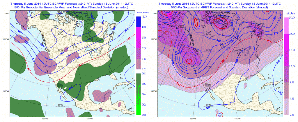
As we look into the long range, there are some questions that arise.  The questions don’t have to do with warming that’s likely to take place late week 2 (90s within reach), but just how long that ridge and associated dome of heat hangs around.  The European ensembles would imply the bubbling heat ridge will stick around for a few days.

Geopotential32at32500hPa_North32America_240

Meanwhile, it should be noted that the European weeklies disagree with its own ensemble package as they bring a cooler pattern and associated trough back into the Great Lakes and northeast region as we get set to head into the last week of June.  Due to licensing issues we can’t show the European weeklies here, but they deliver quite the trough and cooler than normal air mass around, or just after, the 23rd.

Additionally, the PSD agrees and delivers a cool pattern around June 20th.

z500_anom_f360_ussm


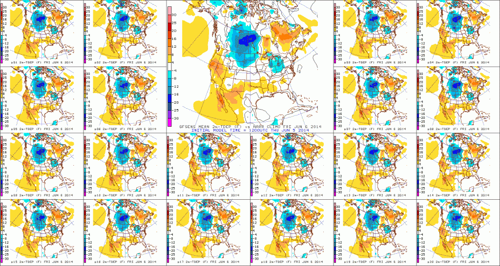
So, while we’re likely to see the hottest weather of the season so far towards Day 10, confidence of this hot weather sticking and holding is very low.  Timing will have to be resolved as it always does in long range weather.  Overall, what’s more likely to happen is that this will be a transient hot pattern and we flip the script to one that’s cooler than average as we go into the last week of the month.

Permanent link to this article: https://indywx.com/2014/06/05/battle-developing-mid-late-june/

IndyWx.com