
You must be logged in to view this content. Click Here to become a member of IndyWX.com for full access. Already a member of IndyWx.com All-Access? Log-in here.
Category: PNA
Permanent link to this article: https://indywx.com/video-timing-out-additional-heavy-rain-a-busy-pattern-will-take-us-into-november/
Oct 19
Active Close To October…
Our annual Winter Outlook will debut Sunday morning, November 1st.
A frontal boundary will remain draped over the Ohio Valley through midweek before lifting north as a warm front late week. As we gear up for the weekend, this same front will barrel southeast as a cold front. While it won’t rain the entire time, the end result will be quite an active week with periods of rain (at times heavy).

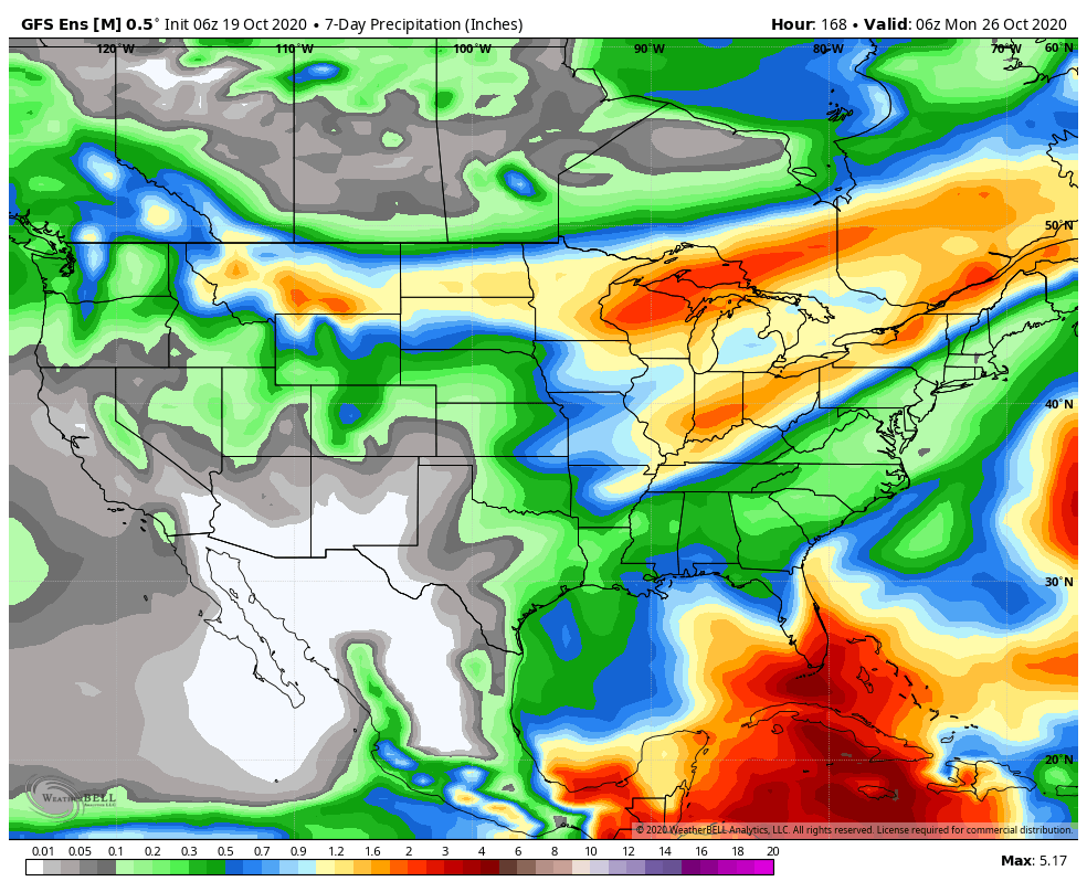
Looking ahead, it appears as if best chances for concentrated rain will come Tuesday night into Wednesday morning, Friday evening, and Sunday into next Monday. This is a hectic pattern and we’ll fine tune if needed. Widespread 1”-2” rain totals (locally heavier amounts) can be expected for the northern half of the state by early next week with 2”-3” totals (again, locally heavier) across the southern half of Indiana (generally along and south of I-70).
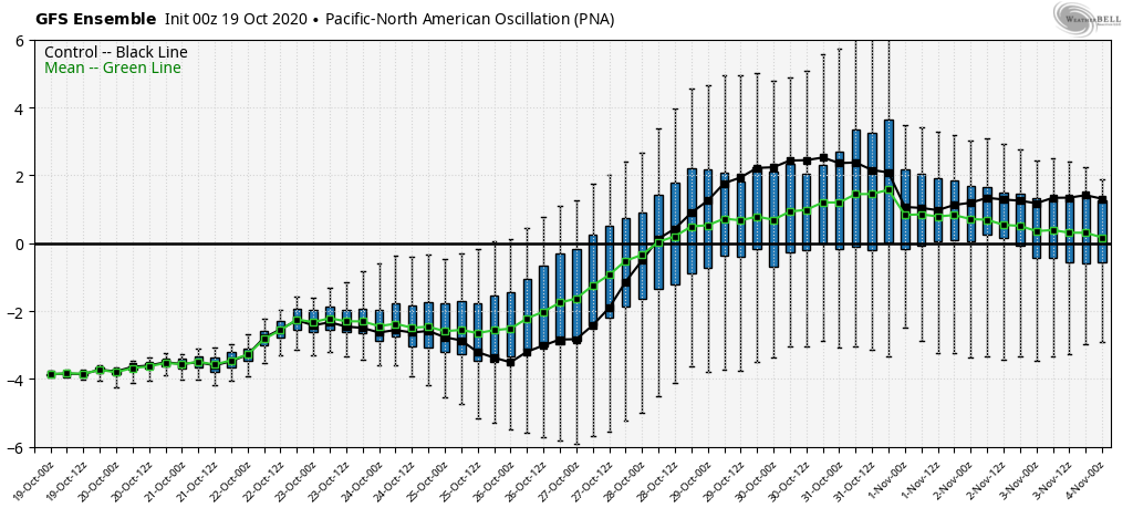
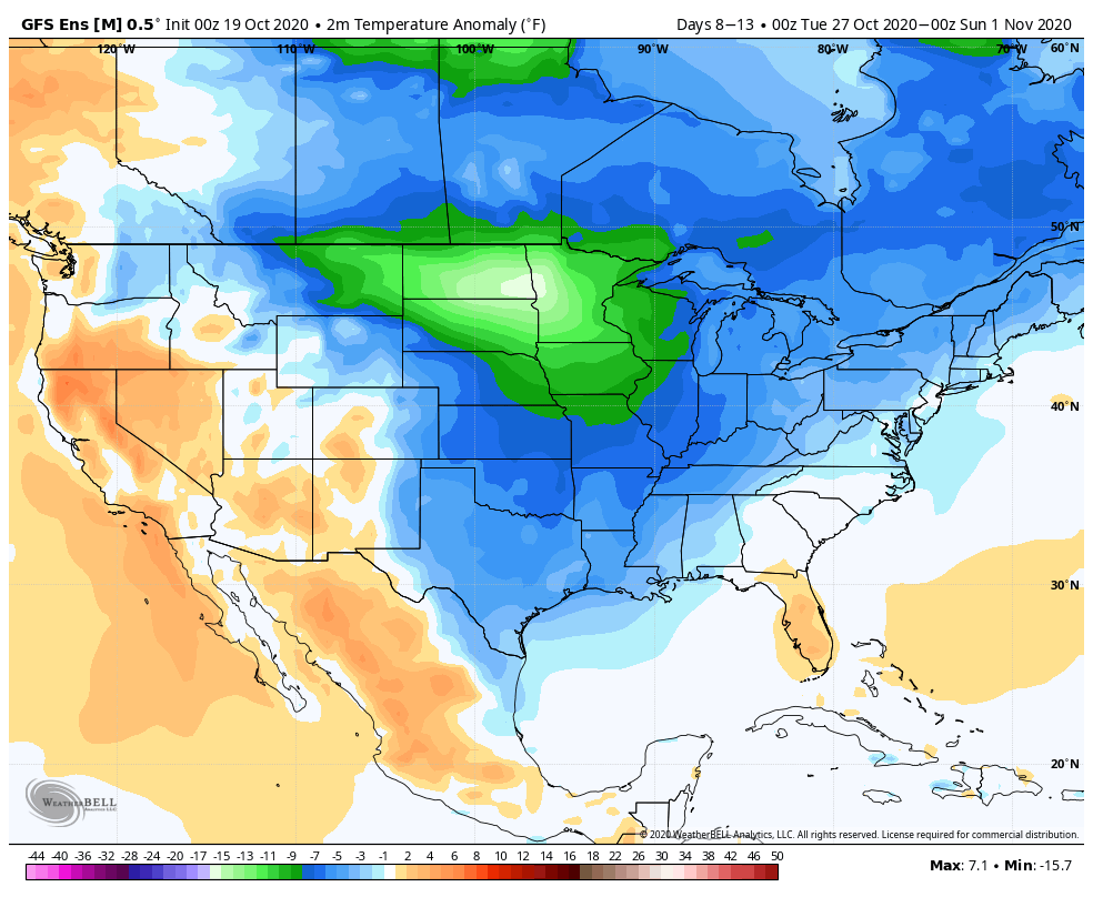
As the PNA pops positive, a colder than normal airmass, and coldest so far this autumn, will settle southeast prior to Halloween. This is the type of pattern that should generate a multi day hard freeze with temperatures falling deep into the 20s early morning.
Permanent link to this article: https://indywx.com/active-close-to-october/
Oct 18
VIDEO: Heavy Rain Overspreads South-Central Indiana Tonight; Unsettled Week Ahead…
You must be logged in to view this content. Click Here to become a member of IndyWX.com for full access. Already a member of IndyWx.com All-Access? Log-in here.
Permanent link to this article: https://indywx.com/video-heavy-rain-overspreads-south-central-indiana-tonight-unsettled-week-ahead/
Oct 12
VIDEO: Getting To Be That Time Of Year- Pattern Turns Busier To Close October…
You must be logged in to view this content. Click Here to become a member of IndyWX.com for full access. Already a member of IndyWx.com All-Access? Log-in here.
Permanent link to this article: https://indywx.com/video-getting-to-be-that-time-of-year-pattern-turns-busier-to-close-october/
Oct 08
Long Range Update: 2nd Half Of October And Open To November…
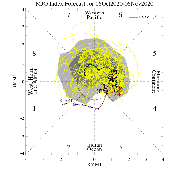
As the fall season “matures” the same MJO phase last month can lead to a much different weather pattern this month (November and so on). Note how the latest European monthly MJO model takes things through 5, 6, 7, and 8 by early November.
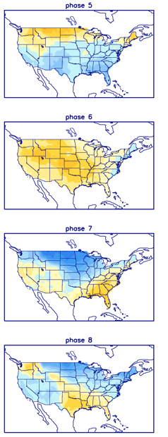
With greater amplitude, I’d say this would take the driver seat behind the pattern evolution into early November, but that’s not the case. Instead, we’ll want to continue to closely monitor the happenings with the EPO and PNA.
Both are pegged to move into favorable phases to bring the chill back into the East as we move through late October.
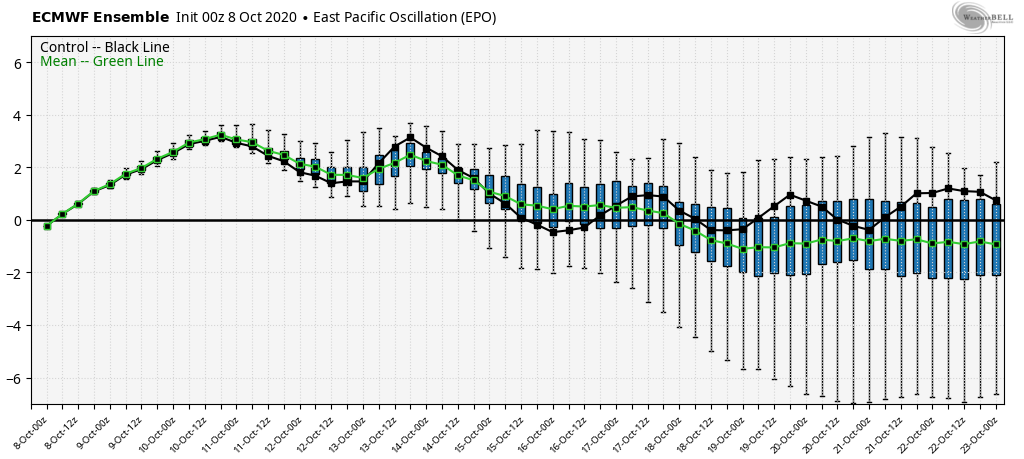
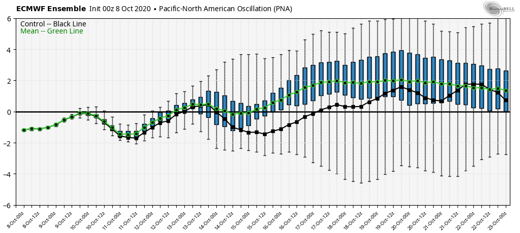
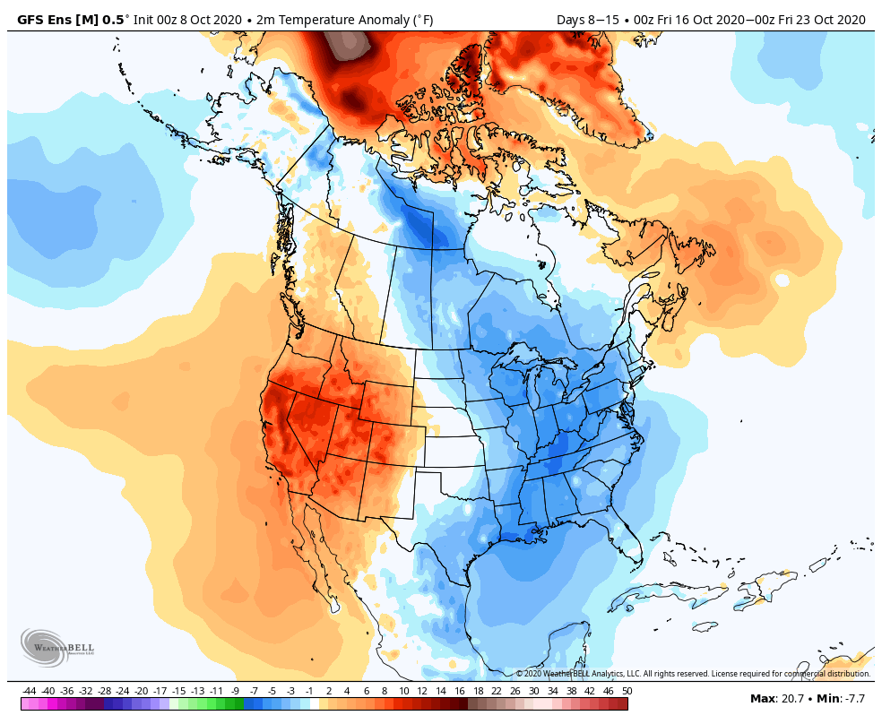
We think next week will feature a “step-down” process to a much chillier following week (Oct. 17th-23rd).

The new JMA Weeklies into the office this morning show a similar pattern evolution:
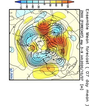

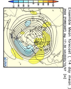

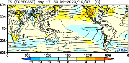
If anything, I’d expect this model to cool further over time in that Weeks 3-4 period. It’s also interesting to see the high latitude blocking shown to remain intact (that can really begin to have more of an impact downstream once to November).
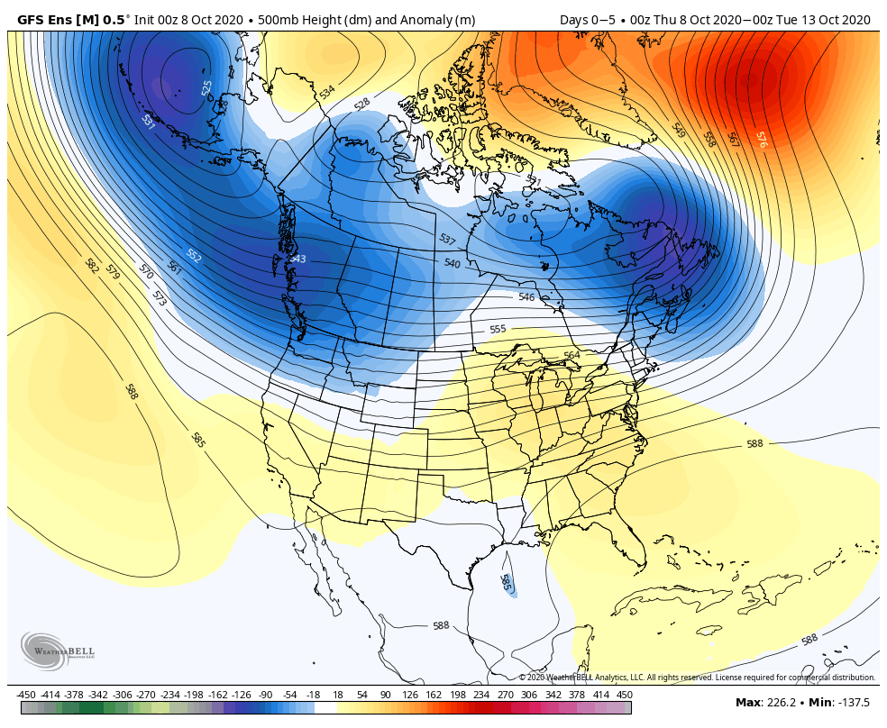
Unfortunately, it’s a continued dry pattern. We’ll have more frequent frontal passages as we move through the back half of the month, but these will likely be moisture starved for the most part. It still doesn’t look like a wholesale wetter pattern will kick in until later in November.
Permanent link to this article: https://indywx.com/long-range-update-2nd-half-of-october-and-open-to-november/