Category: PNA

Times Are Changing, Or Are They?

January-to-date is running milder than normal across the region- to the tune of 3.3 degrees (F).  This is after a frigid open to the month, as you recall.

conus_mtd_t2max_anom_2017The second week of the month warmed significantly and continues, overall, for the next week.

ncep_cfsr_noram_t2m_week_anomThe mid-January warmth is attributed to a roaring PAC jet which is currently helping flood the country with temperatures much more like spring than the dead of winter.  We continue to forecast 60+ this weekend across central IN.

Winter lovers, have no fear as changes appear to be in the offing as we go through the last few days of January and head into February.  The winter so far has featured conflicting signals that continue to try and compete with one another to take hold of the pattern.  Can we get these drivers to align in a way that would pull a more persistent trough into the east for the second half of the winter and, ultimately, set-up a sustained cold pattern helping make up for lost time in the snowfall department?  Time will tell, but we do note the following late month:

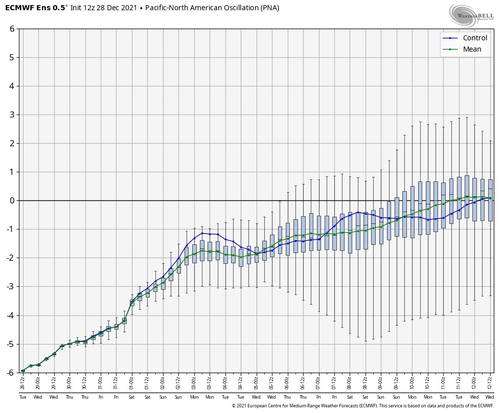
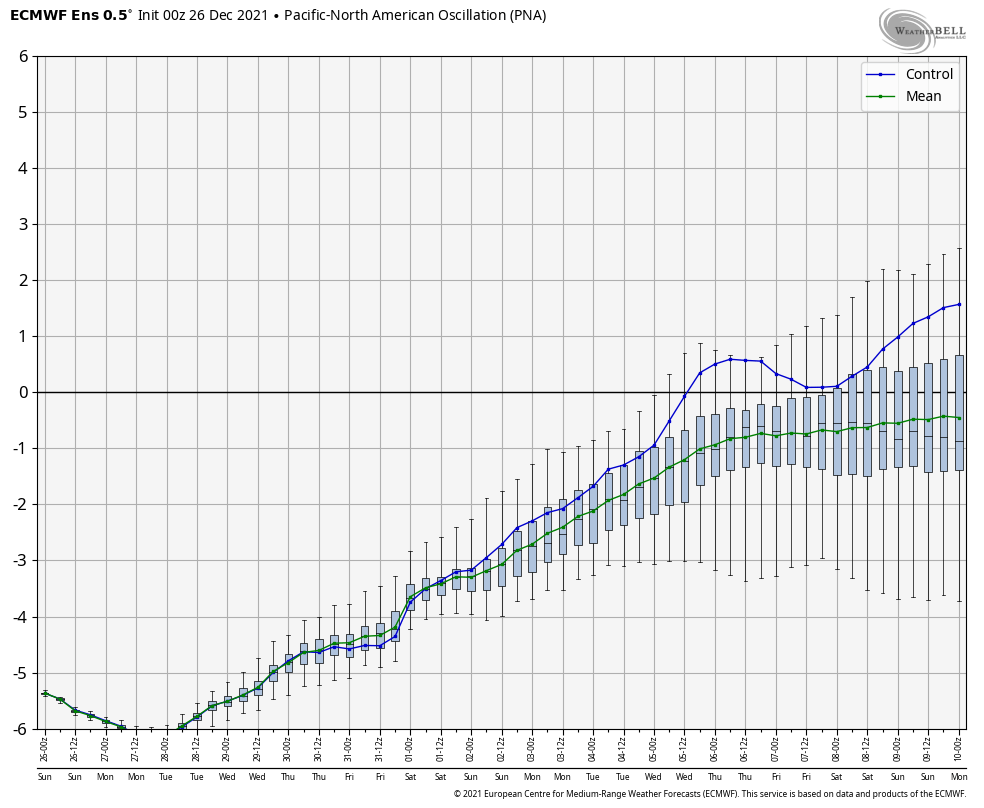
  • (+) PNA pattern
  • Sudden stratospheric warming event
  • High latitude blocking

All are encouraging for a shift back towards a wintry regime.  As always, the devil is in the details and we’re skeptical as to the longevity of these signals.  “Cautiously optimistic” would be the way to sum up our current feel longer-term into the month of February, but we’re not as bullish on lock and hold cold, wintry conditions at this time as what you may hear from some of our national compadres.  Understanding that various drivers can have a different impact mid and late winter as opposed to early is one thing.  It’s also important to note that long term modeling has been abysmal as of late and we want to tread through the next couple of weeks with caution to see whether or not the cold drivers can finally take hold.

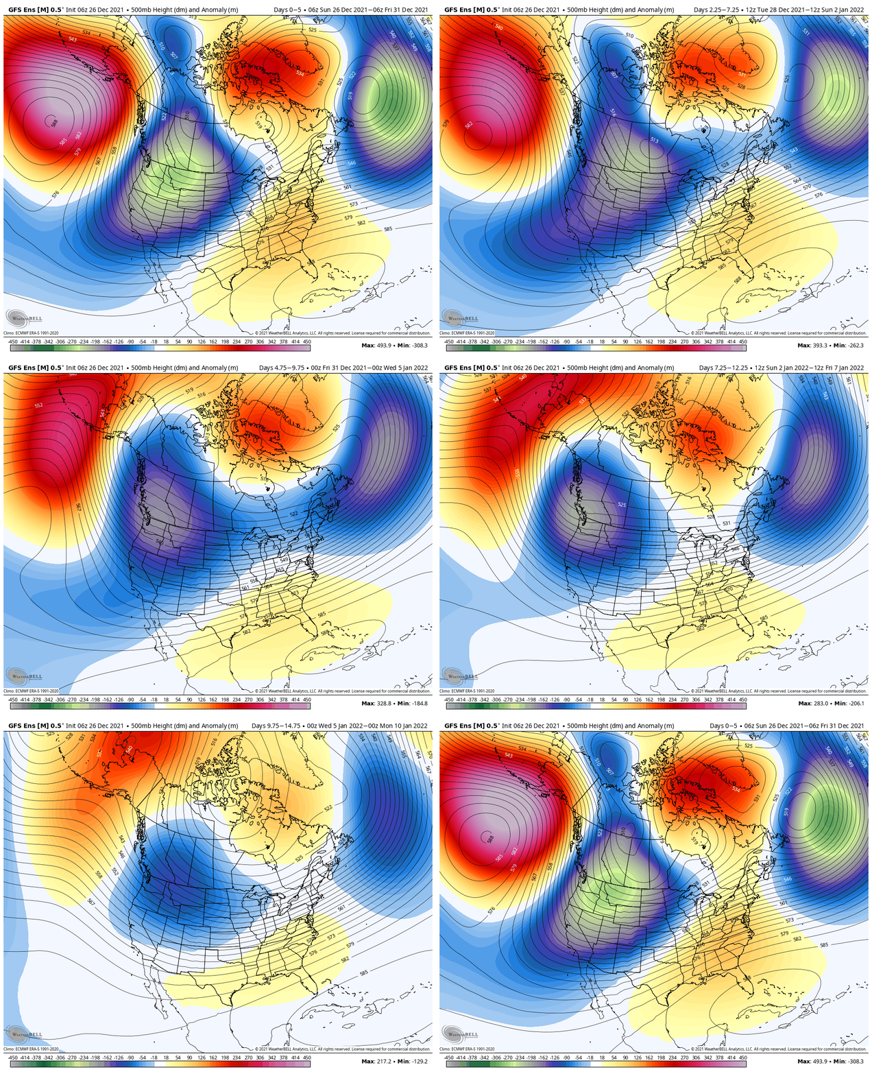
Needless to say, at least through late month, one can see the significant changes take place at 500mb.

Thursday:

ecm_eps_z500a_noram_2This Weekend:

ecm_eps_z500a_noram_5Next Thursday:

ecm_eps_z500a_noram_9Next Weekend:

ecm_eps_z500a_noram_11The pattern begins in the short-term with a look that will power anomalous warmth through the weekend, along with renewed rain chances Thursday night into Friday (another 1″+ for most), but begins to shift next week towards the colder look.  The 2nd (weekend) storm system will be significant and poses a severe risk to the southeast region.  Modeling has backed away on the heavy rain threat Sunday, but showers will be around early next week along with very windy conditions (40+ MPH gusts).  Blocking is forcing the low south.  By the time we get to next weekend, the pattern has done a 180 and in a position to drill unseasonably cold air back into the central and eastern portions of the country.

As far as storms go later in the period, it’s far too early to discuss specifics, but the pattern seems to be one that will promote the chance to get into the act on high-ratio producing clippers.  It’s the first time we can say that this year.  Time will tell…

Permanent link to this article: https://indywx.com/2017/01/18/times-are-changing-or-are-they/

A Word (Or Two) On Where We Think This Pattern Is Going…

Before we get into the updated thinking on the pattern, lets review what we have out:

  • Step-down process to cooler/ colder weather begins in mid-November.
  • Thanksgiving-Christmas period, as a whole, turns wintry and is snowier than average.
  • Our complete 2016-2017 Winter Outlook can be found here.

The first week of November has featured an incredibly warm start to the month. (Image courtesy of MRCC).

month-tdevSpeaking of warmth, 2016 has been a very warm year.

ncep_cfsr_t2m_anom_ytd(The cold of 2014 seems so long ago…)

ncep_cfsr_t2m_anom_2014Back to present.  We’ve targeted the middle part of November to finally beginning “bucking” the recent warm trend.  This won’t happen overnight and will be a battle of back and forth, initially.  Thus, the “step-down” label.  To be clear, November, as a whole, will finish much warmer than average.  It’s virtually impossible to counter the incredibly warm start.  That said, we do anticipate “jabs” of colder air working in here over the next couple weeks. For instance, this weekend will feature lows in the 20s for most and highs not making it out of the 40s Saturday afternoon.  (The average low and high at IND Saturday are 37 and 54).

Despite being in a weak La Nina, the pattern is taking a while to respond.  Remember, we’re coming off one of the strongest El Ninos on record.  Until we slow the PAC jet, significant, long-lasting, changes won’t occur.  We can lean on the AAM (Atmospheric Angular Momentum) forecast for clues as to when this may occur.  You can read more about the AAM here.  My fellow local weather compadres, Michael Clark, Ed Valley, and Kirk Hinz have also written/ blogged extensively about the AAM and resulting impacts.

gfsgwo_1

gfs1When we look at the AAM forecast (above), we note the westerlies may begin to slow (indicative of the negative values) in the 8-10 day period.  This is crucial and, simply put, has to happen for the pattern to begin shifting into more of a position to allow sustained cold to enter the equation.  We want to reiterate that this, in and of itself, doesn’t create the cold, but instead allows the pattern to begin shifting away from the Nino-like (warm) regime into more of a La Nina pattern, as a whole.  – Hey, you have to start somewhere.

If we can finally get the westerlies to slow, other elements are in play that could (and should) lead to a colder pattern as we move forward.  Our (3) big teleconnections are in a position favorable for cold for mid/ late November, into early Dec.

cw5yrrsxaaefhiy-jpg-largeAdditionally, the EPO is forecast negative off the GEFS and EPS. (Images courtesy of Weatherbell.com).

eps_epo_bias

gefs_epo_12Again, this is a cold signal. (Image courtesy of Madusweather.com).

eponew_neg_11novThe ensemble data is also beginning to key-in on higher heights (blocking) developing over the top.  Notice the significant changes in the overall look to the pattern between now and days 11-16. (Images courtesy of Weatherbell.com).

cw5qrw0wgaaphxr-jpg-largeIn summary, and in the face of *most* seasonal data that is screaming warm, warm, warm, we still don’t have any significant changes to our overall thinking of “step-down” mid-November giving way to more sustained wintry-like conditions in the overall sense from the Thanksgiving-Christmas period.  Time will tell and only the Good Lord knows what the future holds, but we’ve done far too much work and research to throw the “game plan” in the trash before the game even begins…

Permanent link to this article: https://indywx.com/2016/11/10/a-word-or-two-on-where-we-think-this-pattern-is-going/

Heat Builds Late Week, But Doesn’t Last…

The pattern remains in a transient state.  An upper ridge will build over the region late week into the weekend.  With this will come the hottest air of the season (multiple days of lower to middle 90s starting Friday, continuing into early next week).  The hottest days appear slated for Friday and Saturday.  Heat indices will approach 105 degrees.

However, just as fast as the ridge builds over the area, we see the “want” to position itself over the Rocky Mountain region.

Hot dome will provide a couple days of highs in the middle 90s Friday-Saturday. Image courtesy of Tropicaltidbits

Hot dome will provide a couple days of highs in the middle 90s Friday-Saturday. Image courtesy of Tropicaltidbits

3


Note the difference of the ridge position by Day 10. Courtesy of Tropicaltidbits

Note the difference of the ridge position by Day 10. Courtesy of Tropicaltidbits

4While some oppressive heat and humidity will impact our local area to wrap up the work week and head into the weekend, this is a pattern where it’s incredibly difficult to deal with any sort of one particular weather pattern for any time of substance.  Looking forward to August, we don’t see this changing.  Remember that word we leaned on to begin summer? “Transient” remains the best way to describe the pattern moving forward, as well.

Additionally, this is a pattern that should result in a return of wet and active times as we put a wrap on July and welcome August.  It’s impossible to nail down the precise details of any one particular neighborhood’s rainfall numbers from this distance, but understand the pattern is one that should yield more locally hefty rains in the weeks ahead.

WetTo close, we’ll leave you with a look at the latest PNA pattern.  This has been the primary driver of our weather this summer, and it also argues any sort of dry, hot weather doesn’t last.  Note the positive PNA returning to close July.  This also lines up well with our idea of unsettled times returning…

Screen Shot 2016-07-18 at 5.58.35 PM

PositivePNA

Permanent link to this article: https://indywx.com/2016/07/18/heat-builds-late-week-but-doesnt-last/

Monday Evening Rambles…

1.)  Tuesday’s upper air disturbance looks to track further and further SW with each and every passing model run.  While we’ll keep an eye on things, it’s apparent that best snow chances will be across far SW counties, and even that may be generous (this thing is tracking much further west than what appeared a couple days ago), courtesy of NCEP.

42.)  A significant warm-up is still on schedule for late week, centered on Friday, where temperatures will likely push to, or exceed, 60 degrees as ridging builds in.  Image courtesy of Tropicaltidbits.com.

13.)  The warmth will be brief, however, as a colder pattern returns (thank you positive PNA), including an interesting look for winter storm potential across the east days 8-10.  (No need to get fancy with specifics at this juncture).

2

PositivePNA4.) The significant cold over the past 7 days has really eaten away at the warm start to the month, courtesy of Weatherbell.com.

ncep_cfsr_noram_t2m_week_anom

ncep_cfsr_noram_t2m_2weeks_anom5.) Nearly 44% of the Lower 48 is snow covered at present. That compares to 25.6% of the Nation covered in snow for the same time last year.

nsm_depth_2016021505_National

Permanent link to this article: https://indywx.com/2016/02/15/monday-evening-rambles-2/

10-Day AG-Weather Outlook…

10 Day AG-Weather Outlook

Issued: 02.07.16

Forecast period: 02.07.16 – 02.17.16

Focal Items:

  • Busy winter pattern from the Plains east
  • Dry and warm across the West
  • Potential widespread winter storm threat days 7-10 from the Plains into the East

Summary: Changes are underway at the beginning of the period with a positive PNA pattern in place.  This will support a drier and warmer than normal time of things across the west with a shift towards much colder than normal temperatures across the eastern half of the country.  Early in the period, we’re tracking a coastal storm that will deliver blizzard conditions to the Cape Monday and a big upper low over the Great Lakes and Ohio Valley.  This will provide a prolonged snow shower event across the areas mentioned above.  Toward the end of the period, we’ll have to remain focused over the southern/ central Plains for the potential of a developing winter storm that would then advance into the Ohio Valley and eventually Mid Atlantic.

Sensible Impacts: Strong ridging across the West will keep things drier and warmer than normal, with the action across the eastern half of the nation.

In addition to snow, wind, and near blizzard conditions that will impact the Cape to open the work week, blizzard conditions will also impact the northern Plains as an upper trough drops south.  The same trough and associated upper level energy will deliver snow showers and embedded blinding snow squalls south into the Ohio Valley and southern Appalachians through mid week, as well.

A very active northwest flow will send light to moderate snow makers southeast out of the N. Plains into the Ohio Valley through the upcoming work week.  Overall, most snowfall accumulations will remain light, with the exception of Snow Belt areas.

A significant winter storm appears to be brewing next weekend and could impact a large portion of the Plains, Ohio Valley, and Mid Atlantic towards the end of the period.

Temperature Anomalies: A very cold time of things is ahead for the forecast region through the period.  In some cases, temperatures will fall to levels some 15-20 degrees below normal.

Tuesday

Temperature anomalies Tuesday. Source: Tropicaltidbits.com

Temperature anomalies Wednesday. Source: Tropicaltidbits.com

Temperature anomalies Wednesday. Source: Tropicaltidbits.com

Temperature anomalies next weekend. Source: Tropicaltidbits.com

Temperature anomalies next weekend. Source: Tropicaltidbits.com

Precipitation: Snowfall will generally be light through the forecast region this week. Despite the light snowfall, very strong winds will likely lead to blizzard conditions in the open country, particularly across IA and MN early in the period. Heavier snow will be possible as the potential winter storm develops next weekend across the central Plains.

Permanent link to this article: https://indywx.com/2016/02/07/10-day-ag-weather-outlook-2/

Overwhelming Evidence On Mid Month Cold…

The step-down cold pattern early January is ongoing, but we’ve been clear with our thinking of even colder air invading around mid month (Jan 10th-20th time period). We wanted to…

You must be logged in to view this content. Click Here to become a member of IndyWX.com for full access.  Already a member of IndyWx.com All-Access?  Log-in here.

Permanent link to this article: https://indywx.com/2016/01/02/overwhelming-evidence-on-mid-month-cold/

Where We Stand…

Some are beginning to grow tired of the seemingly unending warmth and lack of snow, particularly with an above normal stretch of weather coming that includes the Christmas holiday (though not nearly as warm as the European suggested as soon as only a few days ago).

Month-to-date, December has been a warmer than normal month for most of the country. Source: Weatherbell.com

Month-to-date, December has been a warmer than normal month for most of the country. Source: Weatherbell.com

Our winter outlook stated we thought we’d get off to a warmer than normal start, but we were also very clear in stating we thought a rather marked shift to more sustained wintry conditions loomed for mid and late winter.  That period is drawing closer by the day and it’s time to “put up or shut up.”  By “mid winter” we mean mid January.  Yes, that means three weeks out.  Without holding back any punches, we’re fully expecting a colder than average period developing by then (and with staying power), along with plenty of opportunities for wintry precipitation.

You can read our full winter outlook (published in October) here.

The reasoning for our thinking has been outlined in previous posts and in our winter outlook, but, in short, it’s built on the idea of a weakening El Nino and a mean winter upper air pattern that includes W NA ridging (positive PNA regime).  Later in the season, a more sustained negative AO and NAO should establish itself that could carry the wintry regime into meteorological spring.

Current Sea Surface Temperature Anomalies

Current Sea Surface Temperature Anomalies

We think we begin to progress into a “step down” process to the pattern explained above through the early stages of January, and the ensemble data is beginning to support this.

GFS ensembles for early January. Source: Tropicaltidbits.com

GFS ensembles for early January. Source: Tropicaltidbits.com

The modeled W NA ridging is a far cry from what we’ve been dealing with over the past month.

Now we caution that the initial step down to a more sustained wintry pattern won’t occur overnight.  We label it “step down” for a reason.  All the while, it’s a start in shifting away from the anomalous warmth we’ve been dealing with through the month of December.  Initially, cold air will only be marginal, but as things align into the mid/ late winter pattern and we expand snow cover, arctic air will grow in a more widespread fashion.  Something else we’ll begin to have to keep a close eye on?  A potentially active NW flow that features several clippers plenty capable of producing accumulating snow.  We note central-based Ninos are notorious for the clipper parade during the mid and late winter stretch.

In the shorter term, a rather unsettled Christmas week looms.  Modeling will continue to “sure up” the handling of a rather complex storm system after Christmas, as well.  We note runs that have pumped out copious rain numbers and others that suggest wintry precipitation may fall as the cold upper low ejects northeast.  We’ll continue to monitor.

In the meantime, gear up for a rather wet Monday.  We think one half inch is a good bet across the area, with locally heavier totals.  Our updated 7-day in the morning will be a rather busy one.  Talk with you in the AM!

hrrr_t_precip_indy_16

Permanent link to this article: https://indywx.com/2015/12/20/where-we-stand/

Warm Late Next Week; Active Times Loom For The 2nd Half Of December…

You must be logged in to view this content. Click Here to become a member of IndyWX.com for full access.  Already a member of IndyWx.com All-Access?  Log-in here.

Permanent link to this article: https://indywx.com/2015/12/05/warm-late-next-week-active-times-loom-for-the-2nd-half-of-december/

Welcome To Meteorological Winter…

You must be logged in to view this content. Click Here to become a member of IndyWX.com for full access.  Already a member of IndyWx.com All-Access?  Log-in here.

Permanent link to this article: https://indywx.com/2015/12/01/welcome-to-meteorological-winter/

Iron Bowl Saturday: December Rambles…

This is a special day in the McMillan house.  Iron Bowl Saturday only comes around one day a year… Needless to say, the Auburn flags have been on the vehicles since Wednesday, we’re decked out in our orange and blue, and game faces are on for this evening’s matchup.  WAR EAGLE!

As we get set to flip the calendar to December, we wanted to post some latest thinking.

Let’s take a look at the latest teleconnections.  As we’ve been talking, there’s a lot of “noise” in model land, including conflicting signals.  The positive NAO and AO argue for warmer than average conditions, while the positive PNA suggests chillier than normal times should prevail.

We wanted to post the latest model predictions of each teleconnections, courtesy of Weatherbell.com.  Additionally, courtesy of madusweather.com, here’s what each teleconnection “phase” would normally lead to in December.

NAO

Screen Shot 2015-11-28 at 10.55.21 AMNAOpos_12dec

AO

Screen Shot 2015-11-28 at 10.55.07 AMAOpos_12dec

PNA

Screen Shot 2015-11-28 at 10.55.34 AMPNApos_12decSimply based on the teleconnections, you would build a December forecast that would lean more warm than cold, as the short term positive AO and NAO should trump the positive PNA.  As we look at the month, as a whole, the AO and NAO are forecast to trend more neutral, while the PNA remains solidly positive.  Does this suggest colder air, relative to normal, would invade mid and late month?  – Certainly something to watch.

Additionally, the latest Southern Oscillation Index (SOI), has begun to take a negative hit.  This is after weeks of positive SOI values- relative to the base state.

Screen Shot 2015-11-28 at 10.47.52 AM


While it takes a while to impact the pattern, locally, this negative hit does suggest mid and late month could be a bit more interesting from a wintry perspective.  We shall see.

The CFSv2 remains very consistent on a warm month, relative to normal, particularly across the northern tier.

cfs_anom_z500_noram_201512_w3cfs_anom_t2m_noram_201512_w3


While we can’t post the European weeklies here, the latest run suggests colder, and stormy times around Christmas week.  Now, we should also note the overall performance of the Weeklies hasn’t been as accurate compared to normal over the past few months, but it’s another interesting trend to keep an eye on.

The MJO will begin the month in Phase 3 before going into the “wheel house.”  All-in-all, we don’t get a “hat tip” from the expected monthly MJO forecast, with the exception of Phase 3 to begin (warm phase).

EMON_phase_MANOM_51m_full

Screen Shot 2015-11-28 at 11.53.45 AMTo sum up:  Long range forecasting is always a gamble.  Only the good Lord knows what the future holds.  That said, there are times when we feel more confident about our long range, monthly outlooks, more so than normal.

We’ll lean warmer than normal for December (+ 1.5 at IND), and this really plays into our Winter Outlook (slow start expected with the emphasis on the cold and snow mid and late winter), but that doesn’t mean we’re expecting a “boring” month.  Keep in mind November has been both warmer AND snowier than normal, with a very busy 2nd half of the month.

We’ll have plenty of challenges to handle as we rumble through the month no doubt, but we expect the positive AO and NAO to trump the positive PNA to start to the month.  As we progress into mid and late month, we’ll have to be on alert for potential impacts of that significant SOI hit to open the month.  We’ll also keep the Weeklies in check to see if the colder, stormy look Christmas week remains.  It’ll be fun, as always.

To close, here’s one more emphatic WAR EAGLE from our home to yours! 🙂

Permanent link to this article: https://indywx.com/2015/11/28/iron-bowl-saturday-december-rambles/

IndyWx.com