Category: PNA

Eyeing The First Freeze Of The Season Late Next Week…

You must be logged in to view this content. Click Here to become a member of IndyWX.com for full access.  Already a member of IndyWx.com All-Access?  Log-in here.

Permanent link to this article: https://indywx.com/2018/10/14/eyeing-the-first-freeze-of-the-season-late-next-week/

“Flipping The Script” From The Warm Open To Fall…

Permanent link to this article: https://indywx.com/2018/10/12/flipping-the-script-from-the-warm-open-to-fall/

First Frost Of The Season Comes Right On Schedule…

The average date for the first frost and freeze in Indianapolis takes place on October 11th and 14th, respectively.  Right on cue, the first frost of the season will take place for most central Indiana neighborhoods over the weekend.  If you happen to miss out on the frosty conditions this week, reinforcing chilly air will descend on the region early next week.

We forecast (3) of the upcoming (7) nights to fall into the 30s.  This is, obviously, a significant change from the extended summer like conditions we’ve been dealing with as of late.  One primary driver behind the significantly cooler pattern has to do with the change in the PNA.  The shift towards a positive PNA will result in the cooler air remaining in place with more staying power than the fleeting cool shots of a few weeks ago.

A series of cold fronts will sweep through the Ohio Valley over the upcoming couple of weeks and each will likely feature progressively cooler conditions.

With the positive PNA in place, it’s no surprise to see the mean trough setting up shop over the eastern portion of the country.

At the surface, we see the cool pattern taking hold into not only the short-term, but the 10-15 day range, as well.

Permanent link to this article: https://indywx.com/2018/10/10/first-frost-of-the-season-comes-right-on-schedule/

Changing Weather To Open The Work Week…

You must be logged in to view this content. Click Here to become a member of IndyWX.com for full access.  Already a member of IndyWx.com All-Access?  Log-in here.

Permanent link to this article: https://indywx.com/2018/09/23/changing-weather-to-open-the-work-week/

Bet On The Cold…

During wholesale pattern transitions, operational data will struggle at times, including some wild run-to-run swings.  Earlier this week, the European wanted to put early next week in the lower 50s.  At the same time, the GFS suggested lower single digits.  Precisely, it was a difference of 46° between the two models for a high?!  🙂

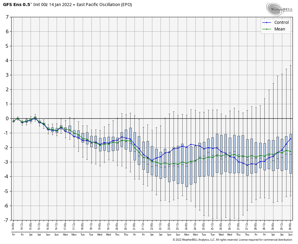
We note the teleconnections (in particular, the EPO) are aligning in a manner conducive for widespread cold.

The GEFS might be a bit quick on dropping the arctic hammer, but the consistency of the model is impressive.  Meanwhile, the European (even it’s ensemble data) has been much less consistent and has really been struggling the past couple of winters, overall, as a whole.

While we can argue as to just how cold it’ll get through the early part of February, the overwhelming message is that a prolonged colder than normal pattern will develop during this time period.

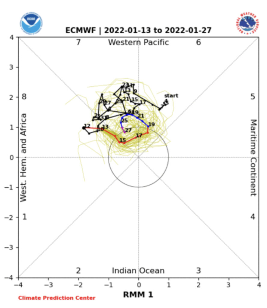
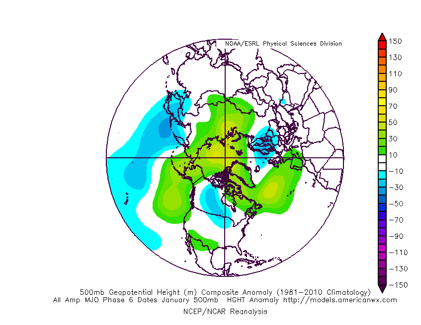
Let’s also keep in mind that the initial cold onslaught is coming in the face of the MJO still rumbling through the warm phases.  We note the European is consistently having to correct towards a more “amped up” MJO- swinging into the cold phases as we approach mid-month.  And it’s mid-February that continues to have us concerned for the potential of truly nasty, severe cold.

As for snow, it’ll come in this pattern.  Again, don’t get caught up in the operational output, but understand that the pattern over the upcoming 7-10 days favors numerous fast-moving snow systems.  While most of these will be light, we’ll have to keep a close eye on things as the potential exists for one of these waves to spin up a moderate event.

As we look ahead to Week 2, the potential is there for a more widespread significant phased interior threat prior to the dumping of the bitterly cold air for mid-month.

As it is, both the GEFS and EPS “mean” paint a bullish signal for piling snow up over the next couple weeks…

Permanent link to this article: https://indywx.com/2018/01/30/bet-on-the-cold/

Transition Begins Back To A Prolonged, Sustained Wintry Pattern…

The January “thaw” has taken hold the past 7-10 days.

Despite the milder air over the past week, January, as a whole, is still running 4° below average at Indianapolis- a byproduct of just how frigid the first half of the month was.

While the January thaw has been nice, times are changing and winter sure seems to be reloading for a very active second half.

Initially, we think it’s the storminess that will be most impressive as a “fight” develops between resistance from southern ridging and a new mean trough pushing southeast.  The end result should be multiple snow and ice makers from the southern Plains into the Ohio Valley and northeast over the upcoming couple of weeks.

Once we get a snowpack laid down, arctic highs oozing southeast will likely lead to bitterly cold air.  Recall our expectation for this pattern to yield at least (1) night of double-digit below zero lows, but it’s more towards mid-month that we think the severe cold takes hold.

Teleconnections are lining up and in overall agreement of cold, wintry times returning.

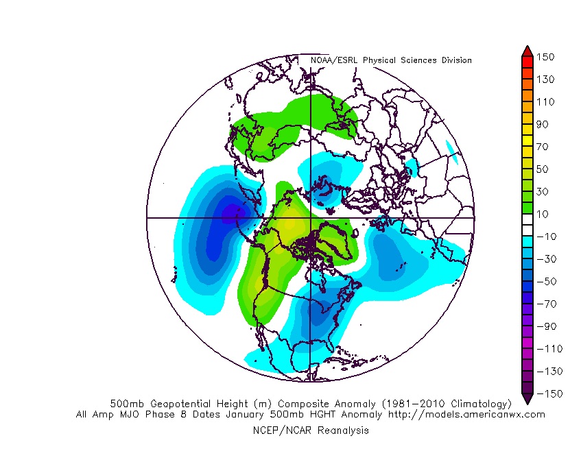
The Madden-Julian Oscillation (MJO) is forecast to rotate into the colder phase 8 as we rumble from early to mid February.  Given the amplitude of the MJO, it should continue to rumble right through the cold phases of 1,2, and 3.

All of these moving pieces that lead up to extended periods of cold, wintry conditions are part of a bigger outcome low solar, easterly QBO winters deal up.  What we should experience with this setup is a 6-7 week period of wintry conditions, including times of severe cold.  It appears to be a snowier version of what we went through late-December through mid-January.  Hang in there, spring will come…eventually.

Permanent link to this article: https://indywx.com/2018/01/28/transition-begins-back-to-a-prolonged-sustained-wintry-pattern/

EPO-PNA Battle

One of the many ingredients we like to throw into the mixing bowl when developing our medium range forecast is the teleconnection breakdown.  Many times, the various teleconnections play into themselves and agree, but, at times, conflicting signals lead to a fight.  At any given time, one or the other “big boy” teleconnections can take control of the pattern and simply overwhelm.  As things stand now, it appears as if the two teleconnections trying to control are the EPO (Eastern Pacific Oscillation) and PNA (Pacific North America pattern), highlighted below.

As we’d expect, as these two fight it out, a battle will ensue across the central and eventually eastern portion of the country.  The negative EPO is a widespread cold pattern, while a negative PNA favors south-central and southeastern ridging (a warmer pattern).

When we look at the latest ensemble data, we see this battle playing out within the modeling.

Eventually, we expect the deeply negative EPO to take control and overwhelm the pattern with cold.  However, as this transition of power takes place, the negative PNA won’t go down without a fight and will likely play a role in the weather leading up to Christmas.

The negative PNA suggests we need to remain on guard for the potential of an interior snow/ ice event around Christmas.  As we’ve been mentioning, from this distance there’s no way to say whether this is an impactful wintry event for our region, or just to our north or south.  We should be able to become more detailed within the next few days…

Permanent link to this article: https://indywx.com/2017/12/16/epo-pna-battle/

VIDEO: Winter Set To Lock In…

You must be logged in to view this content. Click Here to become a member of IndyWX.com for full access.  Already a member of IndyWx.com All-Access?  Log-in here.

Permanent link to this article: https://indywx.com/2017/12/01/video-winter-set-to-lock-in/

Warmth Dominates Now, But A Cold & Wintry Pattern Is Lurking For The Holidays…

The short-term weather pattern will continue to be dominated by rather “boring” conditions for this time of year, along with much milder than normal air.  A weak frontal system will swing through here Thursday and while a light shower is possible, that’s really the only significant (if you want to call it that) weather feature through the upcoming 7-10 days.

In addition to the rather quiet weather, relative warmth will dominate as we open December.  When “normals” feature lows in the upper 20s and highs in the lower 40s, actual overnight lows will only fall into the low-mid 30s and highs will reach the middle to upper 50s.

When we look ahead, the shelf life of this warmth is certainly limited.  The GEFS showcases this shift in the pattern from a warm open to the month towards a much colder pattern very nicely.  The GEFS has other model support, as well.

This is the type of dramatic shift in the overall pattern that not only threatens to “lock in” a colder than average regime, but potentially lead to plenty of wintry mischief to boot, and just in time for the holiday season.

There’s teleconnection support for the wintry shift, as well, leading to further confidence of a significant move towards cold, and potentially snowy/ icy, conditions as the true holiday and Christmas season approaches.

To summarize, while unseasonably quiet and mild conditions will rule in the short-term, Mother Nature sure seems to have an attitude of making up for “lost time” in the medium to longer range.  This is the type pattern that we’ll have to monitor the potential of some sort of leader-follower scenario as the transition from warm to cold takes place, and given the blocky nature of the pattern, it sure seems like we’re heading into a busy time of things from a wintry perspective mid and late month.

Perhaps this will be the scene as Christmas time nears across the Mid West, including central Indiana?  Time will tell…

Permanent link to this article: https://indywx.com/2017/11/27/warmth-dominates-now-but-a-cold-wintry-pattern-is-lurking-for-the-holidays/

“Block Ready To Rock?” Cold Pattern Developing Around Thanksgiving…

Model data continues to suggest a Greenland block will develop as we progress into late-November.  This kind of pattern creates a “log jam” of sorts in the weather pattern and is the type pattern notorious for unseasonably cold regimes across our region.  The overall agreement between various models raises our confidence in this pattern unfolding as Thanksgiving nears.

Such a pattern illustrated above, per the European ensemble (image 1) and the GFS ensemble (image 2), would help drill a tongue of unseasonably cold air through the northern Plains, into the Mid West, and across the East.

A look at the 00z teleconnections this morning shows 3/4 “big boy” drivers going to that cold look for late-November, as well:

We’ve been discussing early snow cover across Canada and the northern tier for weeks and how models would have to “correct” colder as they realize the air masses traveling over the snowpack won’t be able to modify as they normally would without that snowpack.  The differences between this November and last are startling and show how the early snowpack is beginning to “feedback” on itself leading to early-season cold air.

2016 snowpack and temperatures anomalies through the first week of November:

2017 snowpack and temperatures anomalies through the first week of November:

Given the overall look to the pattern downstream, I anticipate the cold will continue to “press” and eventually overwhelm the pattern east as we progress through the second half of the month.

To close, we expect a developing Greenland Block to help drive an unseasonably cold late-November, including the Thanksgiving holiday.  This is the type pattern that can also help generate early season wintry “fun and games,” however it’s far too early to be specific with any sorts of potential wintry events that may eventually come in this pattern.  Stay tuned.

Permanent link to this article: https://indywx.com/2017/11/09/block-ready-to-rock-cold-pattern-developing-around-thanksgiving/

IndyWx.com