Category: Monthly Outlook

October Outlook: Bonus Period Of Warmth…

Updated 09.30.21 @ 7:18a

Before we dig into our thoughts around what lies ahead during the 2nd month of meteorological fall, let’s take a look at what some of the longer range computer models show:

JMA- ‘Mean’ ridge parked over southeast Canada and into the northern Great Lakes with an associated warmer than normal pattern pegged from the northern Plains and points east- most notably along the northern tier. (Slightly warmer than normal here in the Ohio Valley).

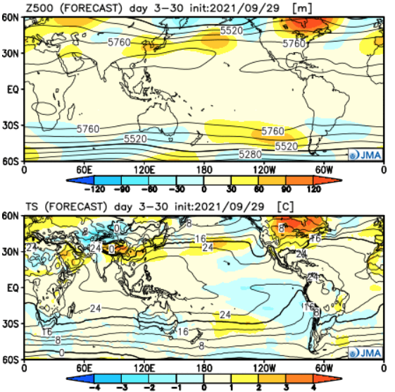
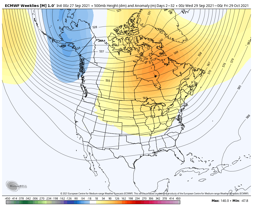
European Weeklies- almost identical to the JMA above. A persistent ridge is shown anchored across eastern Canada into the Great Lakes region. Well above normal warmth is painted across the upper Midwest and western Great Lakes while slightly above normal temperatures take up residence from the Plains and points east.

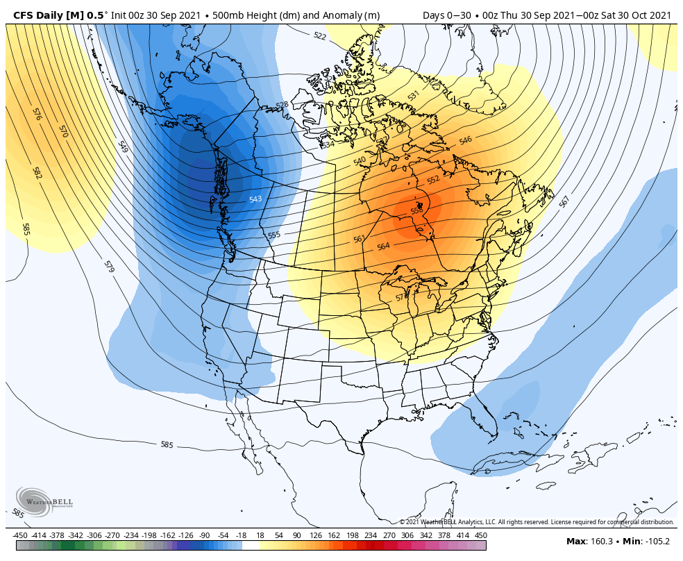
CFSv2- While still showing the significant upper ridge in the same place as it’s JMA and Euro counterparts, the CFSv2 is more bullish on a western trough and associated cooler pattern for that part of the country. Like the other guidance above, the model paints the warm, to much warmer than normal, look from the Plains and points east.

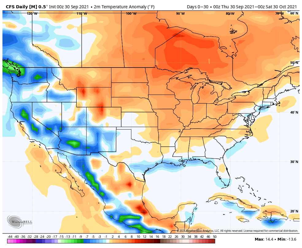
The warm look being shown on the models above should come as no surprise. There’s a tendency for such during La Nina Octobers, along with that persistent upper ridge placement. That’s not to say there won’t be brief intrusions of cooler air at times, but these will likely be fewer than normal by October standards, and “brief” is the key word.

In the short-term, the 2 primary teleconnections we lean on this time of year (PNA and EPO) don’t suggest there’s any reason to go against the October Nina analogs. Perhaps in the longer range (towards late October and into November), there’s a better window to change the pattern up, but my hunch is the more profound pattern shift doesn’t hit and hold until the 2nd half of November and December.

The MJO in large part is expected to remain in the “null” phase through the bulk of the month, meaning we’ll lean heavier on the PNA and EPO.

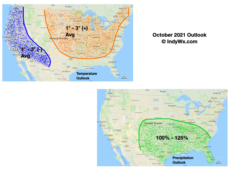
With all of that said, we’ll follow suit with a warmer than normal October (bonus warmth) for most of the country, including here in the Ohio Valley. Precipitation is expected to be near average for October (3.22″ is the average for Indianapolis).

Permanent link to this article: https://indywx.com/october-outlook-bonus-period-of-warmth/

VIDEO: August Outlook; Cool Start To The Month A Hint Of What Lies Ahead?

Updated 07.31.21 @ 9:35a

You must be logged in to view this content. Click Here to become a member of IndyWX.com for full access.  Already a member of IndyWx.com All-Access?  Log-in here.

Permanent link to this article: https://indywx.com/video-august-outlook-cool-start-to-the-month-a-hint-of-what-lies-ahead/

July 2021 Outlook…

Updated 07.01.21 @ 7:13p

You must be logged in to view this content. Click Here to become a member of IndyWX.com for full access.  Already a member of IndyWx.com All-Access?  Log-in here.

Permanent link to this article: https://indywx.com/july-2021-outlook/

June 2021 Outlook…

Updated 05.31.21 @ 9a

With the exception of the far Southwest and Northeast, May 2021 has been a relatively cool month, overall:

More closely to home, May featured “haves and have nots” in the precipitation department. Officially, (as of 5/30), Indianapolis is running more than 2.6° below normal on the month and 1.03″ below normal in the precipitation department.

As we look to June, the first week, overall, should open with slightly below normal temperatures, but there are changes in the offing that will promote significant warming in the Week 2 time frame (June 7-14). Note how the trough providing the cooler air in the immediate term is replaced with the expanding ridge over the Great Lakes.

This should provide us a shot to touch the 90° mark during the aforementioned period at least on a couple of days. Regardless, we can expect rising humidity levels and a more summer-like feel. (I suppose that’s appropriate here on the first day of the unofficial start of summer).

Longer term, we need to keep close tabs on the MJO. Longer range data suggests the amplitude we’ve seen as of late will collapse.

A big drop negative in the PNA will promote the Week 2 heat that we mentioned above. Thereafter, it appears as if the PNA will want to rebound closer to neutral (heat shouldn’t hold).

As a whole, we believe the drought-stricken West will be the breeding ground for big time heat while things are much more transitional across the East (leading to near seasonal temperatures. As for precipitation, we’re expecting a wetter pattern to emerge for the Deep South, TN Valley, and into the eastern Ohio Valley in the month ahead. Meanwhile, the already dry ground across the West is likely to only worsen, unfortunately.

For perspective, averages for the month of June here in central Indiana include highs in the lower 80s (82.0° at IND), lows in the lower 60s (62.9° at IND), and nearly 5″ (4.95″ at IND) of rain.

Permanent link to this article: https://indywx.com/june-2021-outlook/

May 2021 Outlook: Same Theme For Some While The Pattern Changes For Others…

Updated 05.01.21 @ 4:14p

You must be logged in to view this content. Click Here to become a member of IndyWX.com for full access.  Already a member of IndyWx.com All-Access?  Log-in here.

Permanent link to this article: https://indywx.com/may-2021-outlook-same-theme-for-some-while-the-pattern-changes-for-others/