VIDEO: Cooler, Drier Air Arrives This Afternoon; Major Model Differences This Weekend…
You must be logged in to view this content. Click Here to become a member of IndyWX.com for full access. Already a member of IndyWx.com All-Access? Log-in here.
You must be logged in to view this content. Click Here to become a member of IndyWX.com for full access. Already a member of IndyWx.com All-Access? Log-in here.
You must be logged in to view this content. Click Here to become a member of IndyWX.com for full access. Already a member of IndyWx.com All-Access? Log-in here.
Lovers of fall weather sure don’t want to see Phases 8 or 1 of the MJO in September and October. These are flat-out blow torch phases across the eastern half of the country and sure enough, that’s what we’re forecasting over the better part of the next couple of weeks. With an amplified MJO, we put more stock into this signal than others (EPO, for example) in building out our Weeks 2-3 forecast.

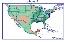
This is not only a warm signal for our immediate region, but a wetter signal as well.
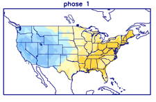
It should be no surprise to see the models paint a very warm picture over the next couple of weeks with this MJO “stalling” in Phase 1. This will lead to a persistent eastern ridge (any cooler air will be very transitional) along with western cold and early snow.


Although things will turn more active, locally, the wettest anomalies should be centered just off to the west and north of our immediate region through the balance of the upcoming 14 days.

While we’ll continue to deal with “bonus” summer-like conditions, the overall pattern from a bigger picture is one that shows fall and winter are, indeed, just around the corner… Note how the snow cover is expected to expand over the next couple of weeks west and north.


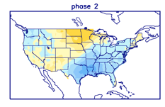
This is worth keeping an eye on. With the MJO showing a tendency to become more amplified, it’s only a matter of time before we swing into the much colder Phase 2 (thinking we need to watch mid-October). Phase 2 in and of itself will be a rather abrupt shift given just how warm we’ll be the next couple of weeks, but when you add in the fact that we’ll likely be looking at a fast start to the snow season, it may come as even more of a shock as the air mass won’t be able to “modify” on its journey southeast.
We’ll continue to closely monitor…
Enjoy your college football Saturday!
You must be logged in to view this content. Click Here to become a member of IndyWX.com for full access. Already a member of IndyWx.com All-Access? Log-in here.
You must be logged in to view this content. Click Here to become a member of IndyWX.com for full access. Already a member of IndyWx.com All-Access? Log-in here.