VIDEO: Reasons To Buy Into The Colder Change Early February…
You must be logged in to view this content. Click Here to become a member of IndyWX.com for full access. Already a member of IndyWx.com All-Access? Log-in here.
You must be logged in to view this content. Click Here to become a member of IndyWX.com for full access. Already a member of IndyWx.com All-Access? Log-in here.
You must be logged in to view this content. Click Here to become a member of IndyWX.com for full access. Already a member of IndyWx.com All-Access? Log-in here.
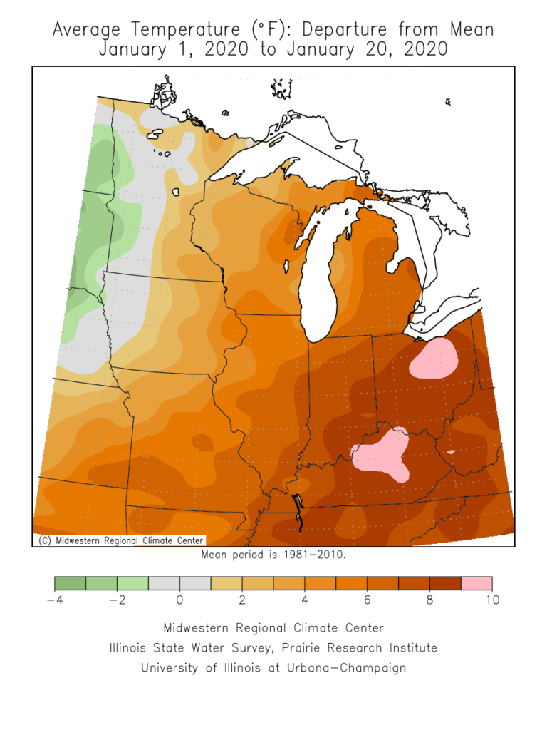
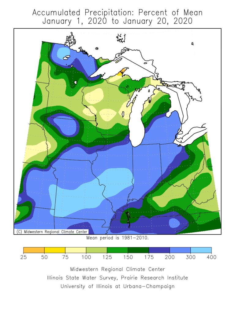
January is flying by! With only 10 days left in the month, Indianapolis is running a whopping 8.2° above normal along with more than 3″ above normal in the precipitation department (unfortunately for snow lovers, this excess moisture has fallen primarily as rain, as IND is running a deficit of 5.2″ in the snowfall department).
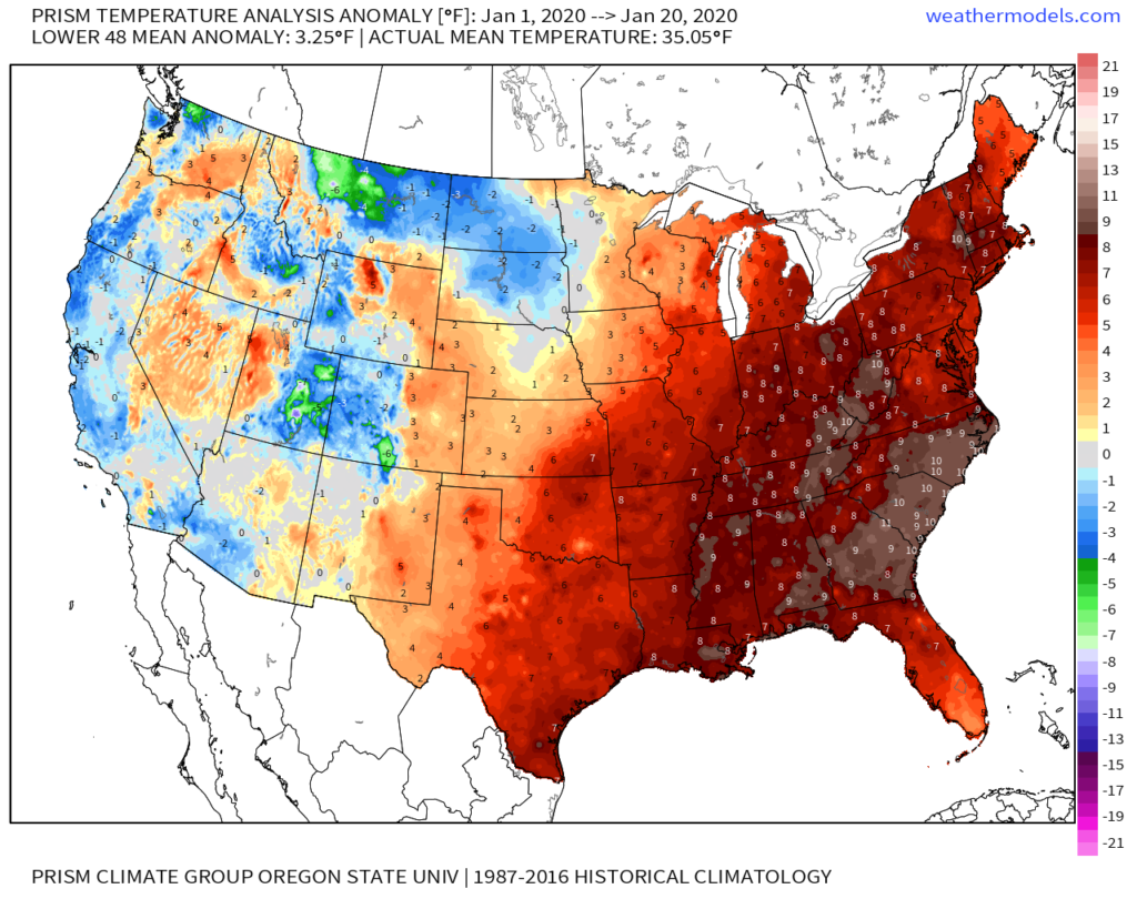
On a broader scale, here’s a look at the current month-to-date temperature anomalies for the Lower 48 as a whole:
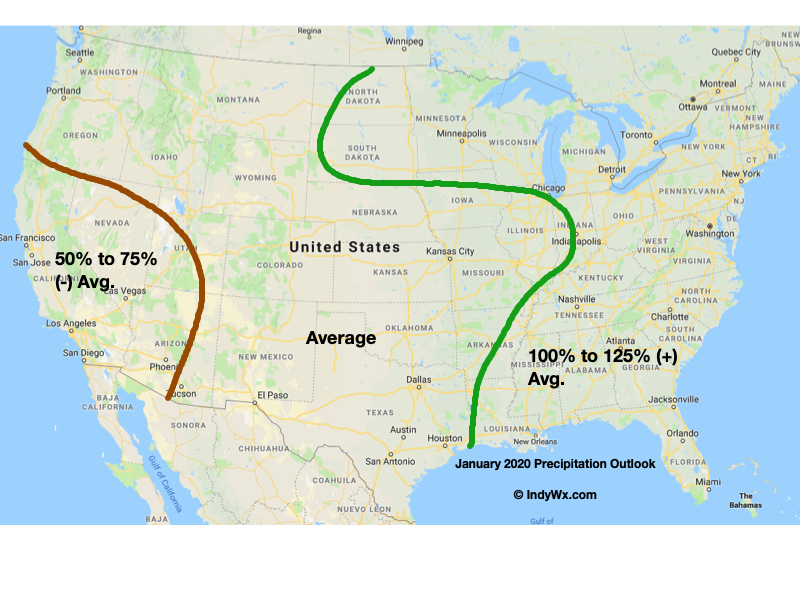
As a refresher, our January forecast looked like this:
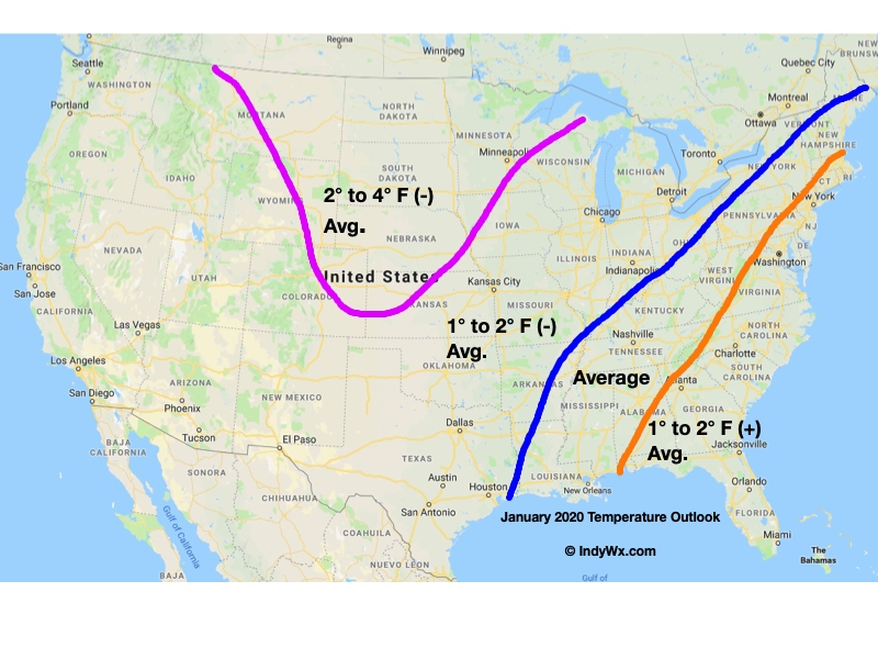
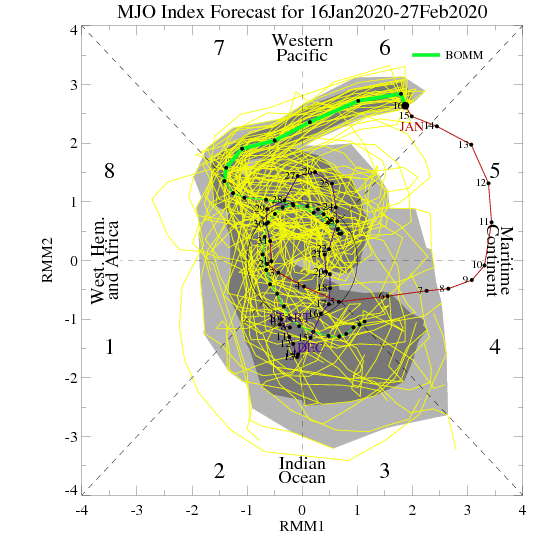
The baseline of this thinking had to do with the idea we had that the MJO would roll out of the warm phases (5 and 6) and strongly into the colder phases after mid-month. Secondly, the other driver was the thought that the current SST configuration in the north Pacific would “force” a negative EPO as the winter season matured.
While the MJO did, indeed, rumble out of the warmer phases just after mid-month, the EPO has not cooperated. Furthermore, instead of the MJO tracking into Phases 8, 1, and 2, it appears it wants to go into the “null” phase to figure out its ultimate destination for the 2nd half of winter (this will be key with Feb. and March). While this doesn’t necessarily support warmth, it doesn’t offer enough ammo to fight the warm signal from the strongly positive EPO.
Now that we’re beginning to turn the page to the 2nd half of winter, there are other items to begin paying closer attention to. In addition to the EPO and MJO, some of these features include the AO, NAO, and PNA. With that said, to drive more of a consistent colder than normal theme, we need to get the EPO at least into the neutral range as some of the other ingredients noted above transition into more favorable colder phases. With a strongly positive EPO, it’ll be tough to sustain well below average temperatures.
With all of that said, all hope is not lost for winter lovers. Climatology speaking, we’re in the coldest time of the year. Even in “marginally” cold patterns, or even “warm” patterns this time of year, wintry issues can create headaches. Secondly, it’s worth paying close attention to the MJO over the next couple of weeks as some of the data wants to take things out of the null phase and transition towards the traditionally colder phases of 8, 1, 2, and 3.
As it is, the next couple of weeks should present a fairly active storm track across the region. In the face of what should truly be a “torch” pattern, the saving grace (at least for fans of winter weather) has to do with the strong Hudson Bay ridge and tendency this kind of pattern has to force stormy times underneath. While far from a “slam dunk,” these kind of patterns can produce- even in the face of a strong positive EPO.
If you had to choose, would you rather have a bitterly cold and dry regime or seasonably mild with at least being on the playing field for wintry mischief over the next couple of weeks?
More in the AM, friends. Make it a relaxing evening! 🙂
Friday will dawn dry, but the mid and high level cloud canopy will be a sign of things to come. These clouds will lower and thicken through the day and eventually give way to a wintry mix by evening. While there may initially be a period of snow (especially north of Indianapolis), the majority of the “overrunning” precipitation should fall as a mixture of sleet and freezing rain. In and around Indianapolis and points north, a light “glaze” of ice is possible Friday evening of up to .10″ (after the possibility of a coating of snow).
Dry air will likely have to be overcome at first, but a burst of snow is possible into the city around 5p to 6p before the transition over to the sleet and freezing rain mixture. Eventually, the icy mixture will transition to a cold rain prior to sunrise Saturday.
MUCH colder air will pour into the state Saturday evening with temperatures falling into the 10s prior to midnight Sunday morning and wind chills into the single digits.

As we look longer term, we don’t see any reason to alter our ongoing thoughts of a colder pattern taking hold, overall, over the upcoming 10-14 day period (and likely into the first half of Feb.). We’ve covered our reasoning in previous posts (Phase 7 of the MJO, positive PNA, neutral EPO, etc.). What’s interesting to note is the rather stark difference in the handling of the EPO between the negative GEFS and positive EPS. The likely end result will be somewhere in between; hence our neutral EPO forecast. At the end of the day, it’s really not the EPO, PNA, or NAO that will drive the mean pattern, but the MJO. And with that said, Phase 7 of the MJO features a cold, stormy look.

The high latitude blocking screams for an active storm track across our neck of the woods (as does the slightly positive PNA and neutral EPO). Sure enough, the latest modeling is going towards this stormy look (active southern stream) in the medium to long range period.
A great mentor once taught me to always be leery of ridges over Hudson Bay in the winter time. Time and time again, this pattern setup results in fairly widespread winter storm events through the Lower 48 and we think there is increased potential in this sometime during the Jan. 25-31 time period. While there’s no way to be specific, just keep a mental note in the back of your mind for this threat.
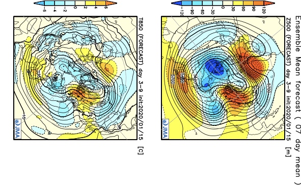
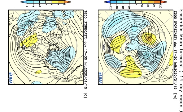
In closing, a review of the latest JMA Weeklies shows a significantly different pattern than what we’ve grown accustomed to as of late taking up residence through the bulk of the upcoming 3-4 weeks. Given the above, it would be tough to argue this look…

Fresh video update will hit in the AM with new thoughts around tomorrow evening’s winter weather maker.
You must be logged in to view this content. Click Here to become a member of IndyWX.com for full access. Already a member of IndyWx.com All-Access? Log-in here.