Updated 06.19.22 @ 9:40a
You must be logged in to view this content. Click Here to become a member of IndyWX.com for full access. Already a member of IndyWx.com All-Access? Log-in here.

Jun 19
Updated 06.19.22 @ 9:40a
You must be logged in to view this content. Click Here to become a member of IndyWX.com for full access. Already a member of IndyWx.com All-Access? Log-in here.
Permanent link to this article: https://indywx.com/video-july-nears-reasons-why-we-arent-buying-into-persistent-heat-in-the-longer-range/
Jun 16
Updated 06.16.22 @ 7:50a
You must be logged in to view this content. Click Here to become a member of IndyWX.com for full access. Already a member of IndyWx.com All-Access? Log-in here.
Permanent link to this article: https://indywx.com/video-long-range-outlook-and-getting-set-for-a-gorgeous-fathers-day-weekend/
Jun 11
Updated 06.11.22 @ 8:37a
The upcoming week will feature some of the hottest temperatures we’ve seen, for at least some areas, in close to a decade. But, unlike, that infamous summer of ’12, the duration of the pattern won’t have nearly the staying power. Nonetheless, you can’t sugar coat 3+ days of lower to middle 90s for highs and lower-middle 70s for lows. That’s what we’re looking at Tuesday through Thursday before a late week cold front provides relative cooling relief to close the week. (By this time next week, we’re talking about lows dipping back into the 50s. Ah, how refreshing that’ll be after the midweek heatwave).
While we’ll have a video posted detailing the shorter-term weather a bit later this morning, I wanted to briefly chat around why I don’t think we’re looking at any sort of long-lasting heat anytime soon. That’s not to say “bursts” of hotter temperatures won’t make themselves felt from time to time, but, overall, the drivers behind the pattern through the remainder of meteorological summer argue much more strongly for a transitional type regime, as opposed to any one sort of pattern (hot or cold- relative to normal) locking in with staying power. Is there a chance that idea is a bust? As with everything pertaining to the future, there’s always a chance.
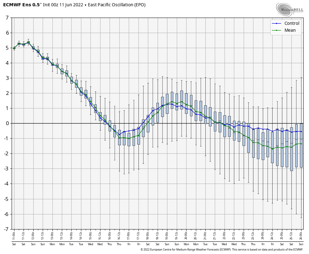
With that said, it’s my opinion that the Pacific SST pattern is going to make it difficult for sustained heat (again- relative to normal) east of the MS River this summer. This PAC SST pattern argues much more for an up and down of the EPO and PNA, favoring more of a negative EPO/ positive PNA overall. Even in the short to medium term, we see this taking place:


We’ll have to obviously keep an eye on the MJO, but the end result will likely continue to be a scenario where just as soon as you might think a persistent pattern is getting set to “lock-in,” we’ll see a transition out of the said pattern for a period of time.
“Transitional” is the key word we’ll continue to ride for the foreseeable future.
Permanent link to this article: https://indywx.com/taking-a-stand-on-the-heat-in-the-longer-term/
Jun 09
Updated 06.09.22 @ 1:45p
You must be logged in to view this content. Click Here to become a member of IndyWX.com for full access. Already a member of IndyWx.com All-Access? Log-in here.
Permanent link to this article: https://indywx.com/video-serious-heat-humidity-builds-into-early-next-week-discussing-when-cooler-times-return/
Jun 03
Updated 06.03.22 @ 5a Confidence remains high in what will likely be a cooler than normal stretch of weather, overall, through the middle part of June. Wildcards thereafter include whether…
You must be logged in to view this content. Click Here to become a member of IndyWX.com for full access. Already a member of IndyWx.com All-Access? Log-in here.
Permanent link to this article: https://indywx.com/long-range-outlook-june-pattern-and-looking-at-meteorological-summer-as-a-whole/