
You must be logged in to view this content. Click Here to become a member of IndyWX.com for full access. Already a member of IndyWx.com All-Access? Log-in here.
Category: Long Range Discussion
Permanent link to this article: https://indywx.com/video-enjoy-the-quiet-weather-while-you-have-it-significant-changes-await/
Dec 29
Warm, Wet Highlight January 2021 Outlook…
As we get set to flip the calendar to a new year, does the similar pattern that dominated in December roll over to January? Yes and no. While we anticipate the relative warmth to remain intact through the majority of the month, the storm track looks to aim itself through the Ohio Valley region for the better part of the month, helping generate above to well above average precipitation.
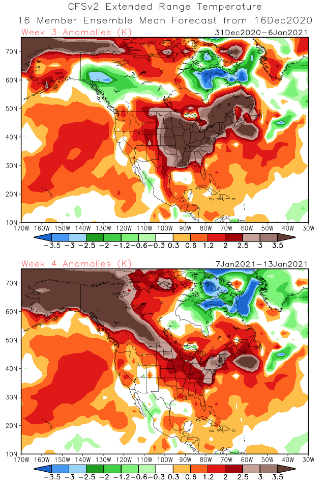
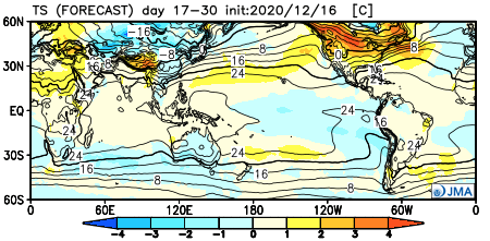
Forecast Models: Note the consensus on the warm (relative to average, of course), wet theme.
CFSv2
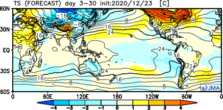
JMA

European


The MJO is becoming increasingly interesting. The European modeling wants to keep the MJO in the “null” phase, but the American modeling is showing the MJO get more amplified with time as we go through early-mid January.

Despite favorable phases for cold (AO and NAO), the Pacific pattern (namely strongly positive EPO) is wrecking havoc on any sort of cold trying to get involved in the pattern with any sort of staying power. Unless we can get a disruption of the polar vortex (big “IF” at this point), the relative warmth should continue to dominate.

We think this will be an active month with multiple storms of significance impacting the Ohio Valley. Despite our thinking that relative warmth will dominate, remember January, climatologically speaking, is the coldest month of the year. It would only take 1 or 2 of the expected storm systems tapping into only marginally cold air to generate more meaningful wintry weather and this is something we’ll keep an eye on in the weeks ahead.
Permanent link to this article: https://indywx.com/warm-wet-highlight-january-2021-outlook/
Dec 24
Long Range Update: Merry Christmas Eve From Our Home To Yours…
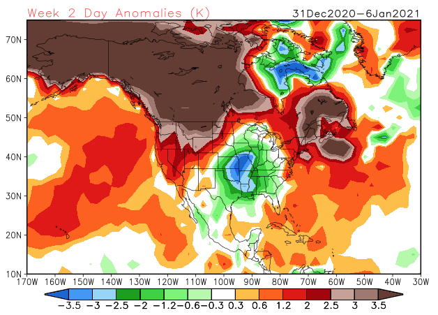
Right off the bat, the theme we want to drive home is that while active, the pattern ahead isn’t overly cold. Cold enough, at times, to create some wintry “fun and games?” Absolutely, but we’re not forecasting a widespread period of sustained cold over the next few weeks.
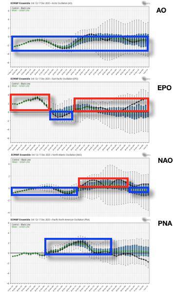
While the teleconnections favor durable cold from an AO/ NAO perspective…
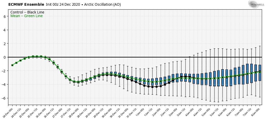

…the EPO isn’t as favorable, and will likely present some warmer times in between the colder shots.

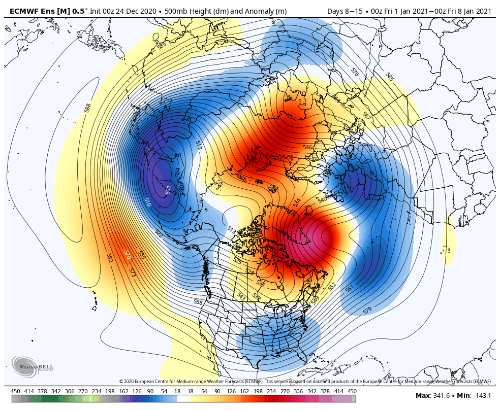
As it is, note how the blocking really matures from Week 1 to Week 2.

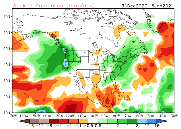
Undoubtedly this will force a stormy period into (at least) the first half of January. At times, initially, Great Lakes cutters are possible, but as we get closer to NYE and into the 1st week of January, itself, I think that’s the window that we really need to focus on for the potential of 1, if not 2, OHV winter storm threats.
The longer range, weekly models are trending in an interesting direction for the 1st full week of January, “marrying” the moisture with the cold, locally.
CFSv2
The JMA Weeklies are also intriguing from an upper air perspective (very similar to what the other ensemble data shows for the similar time frame).

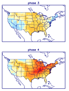
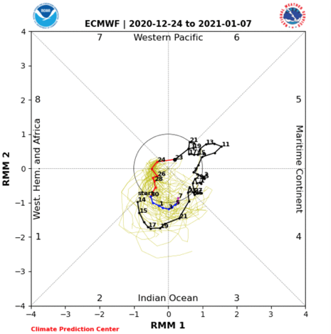
While we’re not ready to unveil our January Outlook just yet (that will come next week), I think we’ll need to start keeping a closer eye on the MJO by the middle and latter part of the month. As things stand now, it appears we may sneak into Phase 2 to open the month (favors cold, locally) before potentially getting into a milder Phase 3 towards the end of the first week.

As things stand now, once the brief arctic intrusion gets out of here this weekend, temperatures will go into a “yo-yo” mode next week as (2) storm systems impact the area between Sunday and Wednesday. The date to keep a closer eye on for potential wintry impacts is more towards Jan. 2-4 time frame as the blocking gets into better position/ matures.
We’ll be back with a video update later today. Until then, Merry Christmas Eve from our family to yours.
Permanent link to this article: https://indywx.com/long-range-update-merry-christmas-eve-from-our-home-to-yours/
Dec 17
Long Range Update: Does The Active Pattern Hold Into Early January?
The MJO is set to remain in the “null” phase through the end of the year.
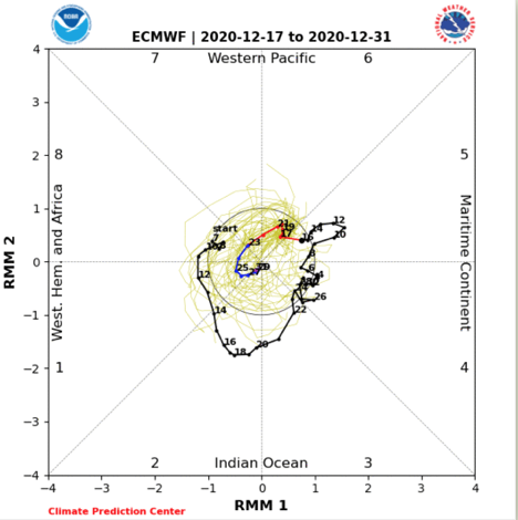
This means we’ll continue to lean on the teleconnections to drive the pattern over the next few weeks.
For the most part, these teleconnection signals remain clustered in a manner that favors a predominantly chilly pattern to close out the year. (Not to say we won’t have a day or two thrown in with milder southwesterly winds).
The period where there’s greatest alignment for cold is centered on Christmas. Not surprisingly, we have an arctic blast dialed up for the big holiday (including highs that might not make it out of the 10s). Thereafter (from top to bottom), the AO remains negative, the EPO trends back to neutral to positive, the NAO trends neutral before heading back slightly negative, and the PNA goes back neutral.
Note the buckling of the jet and associated arctic air intrusion for Christmas.

With the negative AO and trending negative NAO, I’d look for another attempt of an eastern trough just prior or around the New Year.
While our short-term products will focus more on the Christmas storm, the current idea is for more of a progressive system (rain to snow with minimal accumulation Christmas Eve) preceding the arctic blast. We still expect wind chills to fall below zero Christmas morning.
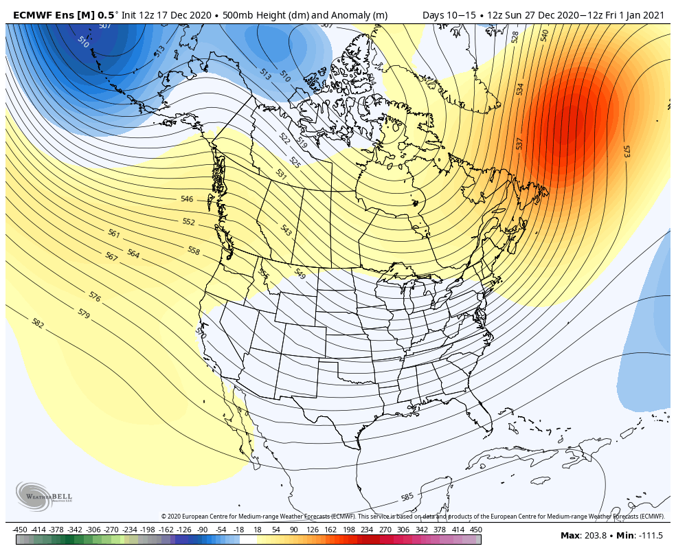
Note the ensemble data continues to show a reflection of a trough across our neck of the woods as we close the year and open up 2021. One also has to like the positives over Canada (at least if you’re a fan of being on the playing field for the possibility of additional wintry events during this time). I’m also intrigued by the north Atlantic ridge as that can lead to eastern storminess and an overall “chaotic” pattern.
Further ahead, our updated Weekly products are bullish on warmth (relative to average) to open up January.

I would caution buying into the “torch” forecast off the long range data above. This is for a couple of reasons: the teleconnection phases and expected neutral MJO. Furthermore, what’s more likely here is that the modeling is either jumping on the warmth in Canada and “overwhelming” the Lower 48 with the warmth, or is way too warm in Canada. It’ll be mighty hard to pull off widespread warmth across the Lower 48 and Canada through the first couple weeks of the new year. The pattern should also continue to offer up a fairly active storm track to open up 2021.
Permanent link to this article: https://indywx.com/long-range-update-does-the-active-pattern-hold-into-early-january/
Dec 11
VIDEO: Near Record High Today; Rain Arrives Tonight And Continuing To Keep An Eye On Early Next Week…
You must be logged in to view this content. Click Here to become a member of IndyWX.com for full access. Already a member of IndyWx.com All-Access? Log-in here.
Permanent link to this article: https://indywx.com/video-near-record-high-today-rain-arrives-tonight-and-continuing-to-keep-an-eye-on-early-next-week/