Long Range Update: “Interesting” Times…
Updated 11.24.23 @ 8:32p
You must be logged in to view this content. Click Here to become a member of IndyWX.com for full access. Already a member of IndyWx.com All-Access? Log-in here.
Updated 11.24.23 @ 8:32p
You must be logged in to view this content. Click Here to become a member of IndyWX.com for full access. Already a member of IndyWx.com All-Access? Log-in here.
Updated 11.23.23 @8:21a Here’s wishing you and your family a blessed and very happy Thanksgiving holiday. We’re so incredibly thankful for your support- and more importantly friendship over the years.…
You must be logged in to view this content. Click Here to become a member of IndyWX.com for full access. Already a member of IndyWx.com All-Access? Log-in here.
Updated 11.21.23 @ 7:30p
You must be logged in to view this content. Click Here to become a member of IndyWX.com for full access. Already a member of IndyWx.com All-Access? Log-in here.
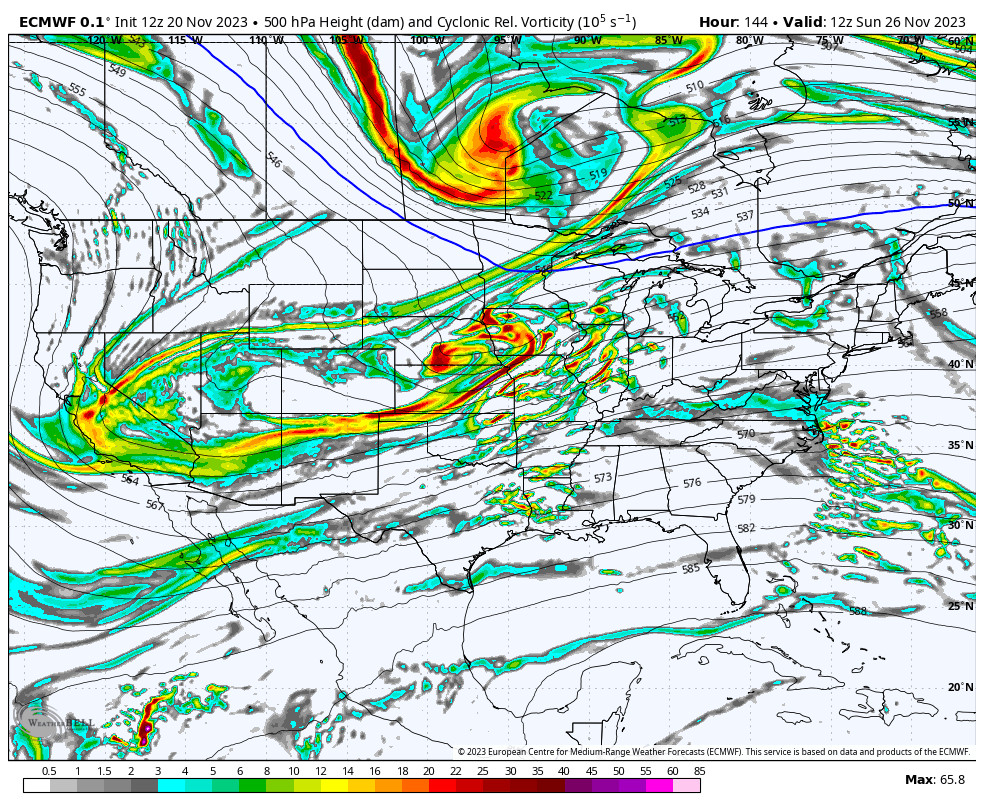
Updated 11.20.23 @ 5:30p
I. The weather pattern will turn progressively colder as we move through the Thanksgiving holiday. This isn’t anything earth-shattering by any stretch, but temperatures running 4° to 8° below normal is pretty stout. There’s also still the potential of an early season arctic “jab” prior to us getting out of the first 3-5 days of December, but that likely comes after this weekend- if at all.
As a whole, it’s a dry pattern that will accompany the chill, but we will want to continue keeping an eye on energy that will eject off the Rockies over the weekend. At times models can underplay these features only to have to correct stronger as we grow closer to the potential event. Will that be the case this time? Impossible to say from this distance- just something we’ll continue to monitor with such a busy travel period. As it is today, modeling wants to “string” the energy out which would essentially be a light or non-event.
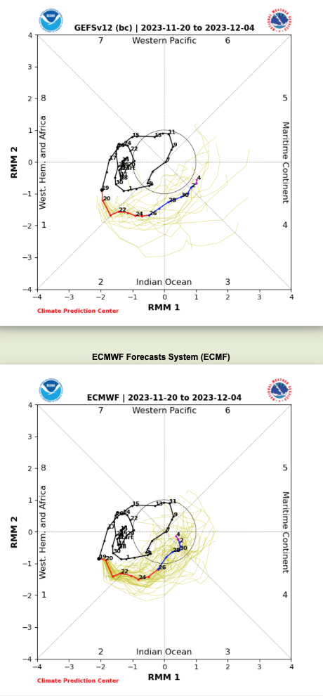
II. While the pattern drivers all are aligned for a cold open (first few days) of December, there’s reason to believe a period of milder than normal air will take foot just after- say sometime between 12/5 and 12/8, or so. That said, we’re in a bit of a fork in the road so to speak.
The East Pacific Oscillation (EPO) is going to pop positive at least for a period of time prior to mid-December. This strongly argues for a relaxation of the cold regime that we’ll endure to open the month. Guidance differs on the handling of the MJO, however. Should the American guidance be correct in taking things into Phase 4, when combined with what we see transpiring with the EPO, then we’re off to the races for at least a 7-10 day period of much warmer than normal temperatures. That said, European guidance collapses the MJO into the “null” phase and even hints at things emerging again in the colder phases come mid December. While we still have time to sort through this “mess,” the idea here is that the cold open to the month will moderate to slightly to moderately above normal for a 7-10 day period leading us into mid-month. Thereafter, I’m becoming increasingly bullish for a renewed cold pattern developing towards the Christmas and New Years holidays…
Updated 11.13.23 @ 1:50p
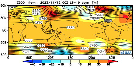
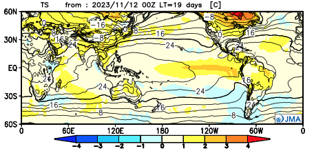
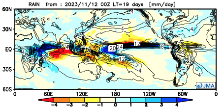
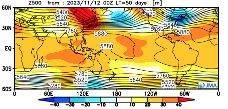
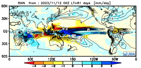
Good afternoon, Clients! As additional seasonal guidance updates, we wanted to take a moment to review the latest trends with you as that data becomes available. Today, the latest JMA monthly product updated and “doubles down” on the idea of an overall mild, but active December morphing into a colder, stormy eastern US regime come January and February. Overall, the model is very consistent from October’s update.
December
Highlights
I. A milder than normal open to meteorological winter, but quite an active pattern on a widespread level- centered Central and Southern tier.
II. Lets keep an eye on the potential of a colder pattern to evolve the last 10 days, or so, of December.
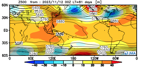
January


Highlights
I. Ridge pulls back into the “sweet spot” and subsequent trough develops across the East. (Would watch for potential of cold to grow more widespread in the next update should this 500mb be accurate, and we think it is).
II. Active Nino southern stream delivers a hectic and busy pattern across the southern tier and up the eastern seaboard. Ripe pattern for eastern winter storm threat(s).
February
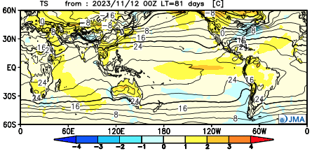
Highlights
I. Persistent pattern from January. If anything, ‘mean’ trough/ ridge positions only become that much more prominent. Cold becomes more widespread across the East, compared to January. Again, should the upper air pattern be correct, I’d lean that the model will have to grow colder in time for this period.
II. Very stormy southern and eastern seaboard. Likely multiple attempts at wintry “fun and games,” including deep into the south with this pattern.