Updated 10.19.23 @ 7:17a
You must be logged in to view this content. Click Here to become a member of IndyWX.com for full access. Already a member of IndyWx.com All-Access? Log-in here.

Oct 19
Updated 10.19.23 @ 7:17a
You must be logged in to view this content. Click Here to become a member of IndyWX.com for full access. Already a member of IndyWx.com All-Access? Log-in here.
Permanent link to this article: https://indywx.com/video-damp-thursday-gives-way-to-a-gusty-saturday-a-lot-to-discuss-over-the-next-10-days/
Oct 17
Updated 10.17.23 @ 5a
You must be logged in to view this content. Click Here to become a member of IndyWX.com for full access. Already a member of IndyWx.com All-Access? Log-in here.
Permanent link to this article: https://indywx.com/video-new-seasonal-guidance-ups-the-ante-for-upcoming-winter-unsettled-close-to-the-work-week/
Oct 12
Updated 10.12.23 @ 10:50a
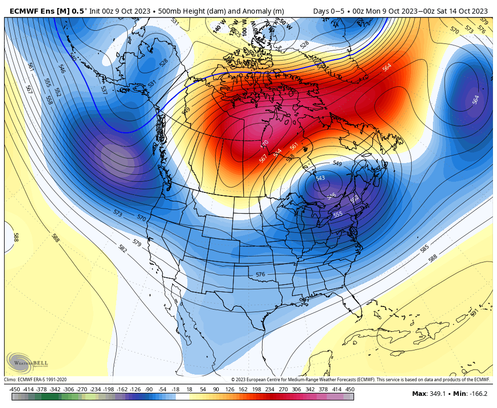
As we roll into the second half of October, a look at the primary pattern drivers suggests there should be a lack of any sort of sustained above normal temperatures.
The PNA (image 1) should remain mostly in a positive state over the next couple weeks while the EPO (image 2) is expected to be in a neutral to negative state.


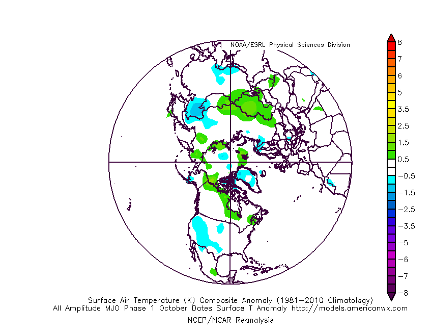
Furthermore, the MJO is forecast to sneak into Phase 1 late month. This is the correlation in October:
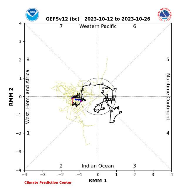
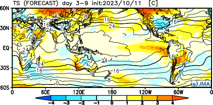
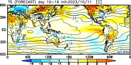
It’s hard to find much at fault with the NEW JMA Weeklies posted earlier today.
Temperatures
Week 1
Week 2
Weeks 3-4
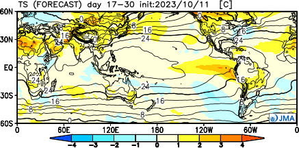
Precipitation should run average to slightly below normal over the span of the upcoming (2) weeks:

Permanent link to this article: https://indywx.com/lr-update-checking-in-on-the-pattern-drivers-to-close-october/
Oct 09
Updated 10.09.23 @ 7:35a
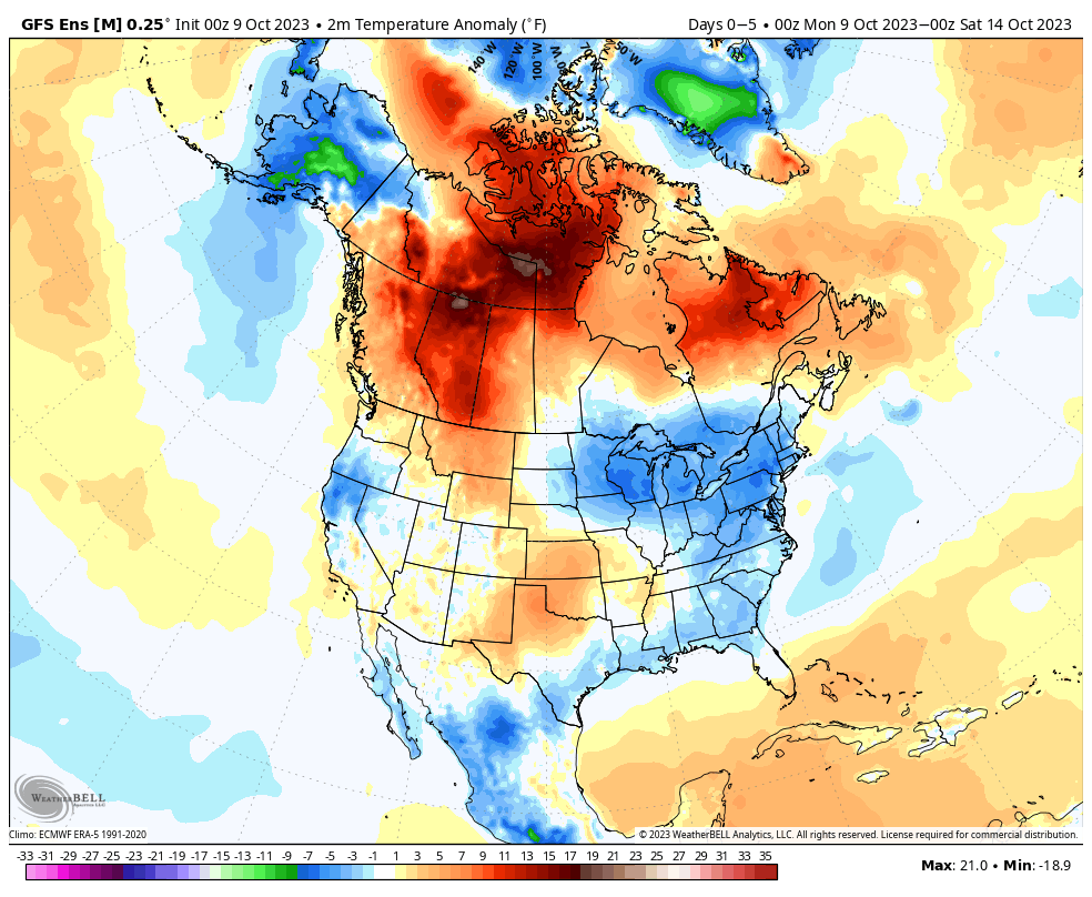
We’re opening the work week with a few scattered clouds and temperatures around the 40° mark. We’re in a pattern that will feature predominantly cooler to colder than normal temperatures over the next 10-14 days with a couple exceptions. We’ll call it a sea of cool with an island of warmth (Thursday and Friday). The relatively warmer temperatures come after the passage of a warm front and ahead of a cold front. The “in between” will feature another period of unsettled and stormy weather to close the work week.
The overall upper air pattern shows that Hudson Bay blocking high and tendency for an eastern trough through the upcoming 2 week period. Another big cold shot will roll in here over the weekend and into the early Week 2 time period.
After a dry start to the week, rain chances will return late Wednesday and early Thursday (warm front) and again directly ahead of the cold front that will sweep through here Friday evening. Rainfall numbers with the passage of this system should check in between 0.25” and 0.75” for most of the region.

As we look ahead, a continued chilly pattern seems to be in store with additional storm dates that include:
10/19-10/20
10/23-10/24
Down the road, the strongly positive PNA and neutral to negative EPO should keep the chill flowing for the most part over the coming couple weeks. Eventually, these progressively colder shots will likely generate the 1st eastern flakes of the season, including for our friends in the beautiful high ground of those east TN and western NC mountains.
Permanent link to this article: https://indywx.com/active-mid-and-late-october-another-unseasonably-cold-shot-on-deck/
Oct 07
Updated 10.07.23 @ 6:09a

Though officially, we’re only a couple weeks into autumn, attention here has begun to shift towards the potential predominant pattern as we push into the holiday season.
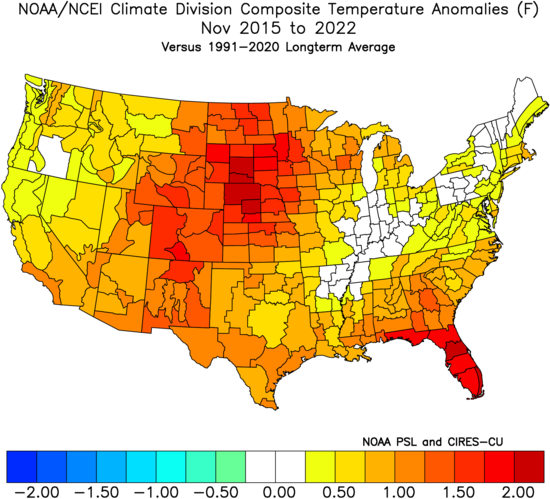
A quick, simple look back over the most recent November and December patterns is a sight that generates anxiety for most winter lovers. At a time when the majority of even non-winter lovers would like snow (i.e. the holidays), well above normal temperatures, and almost record warmth has become all too common over the years.
November 2015-2022
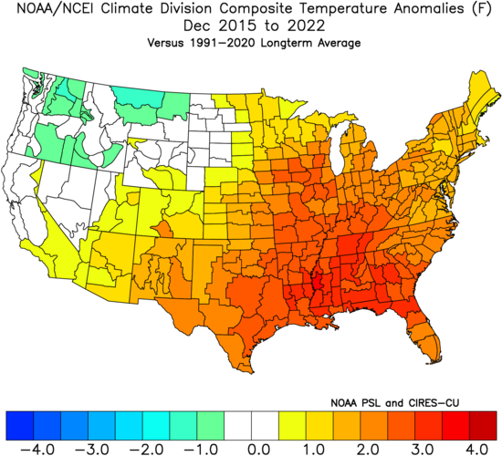
December 2015-2022
Is there reason to believe that could be different this year, especially with our base transition to El Nino? Simply put, not so fast my friend. El Nino winters are notorious for getting off to slower, warm starts. Our research shows that many times November can start cold but that the December pattern flips warmer around these parts. That’s, obviously, not to say it “has” to be that way. Many other factors contribute to the overall regime, but just that when you simply bundle all 1st year Nino events together, it’s more typical than not to find things play out such as illustrated above.
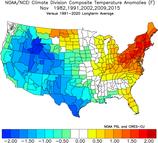
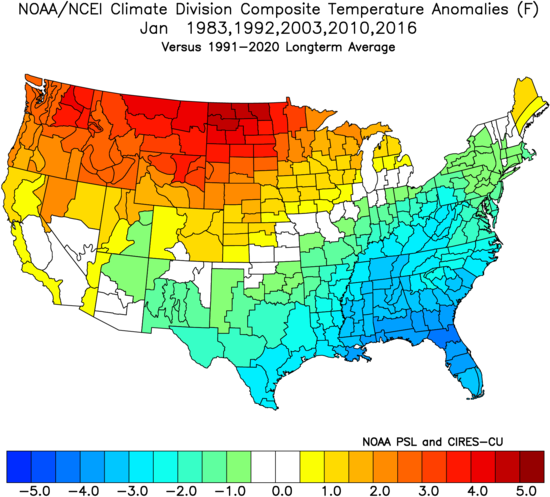
Let’s take a more specific look at our analog package (’82-’83, ’91-’92, ’02-’03, ’09-’10, and ’15-’16) and see what that suggests may be in store as we begin to set our eyes on the holidays.
November: Slightly above normal, locally. Unseasonably cold west and unseasonably warm New England are the headliners.
December: Greatest warm anomalies are centered over the Ohio Valley, in what otherwise is a large-scale warmer than normal regime from the Plains east.

January: The pattern begins to really flip around with cold bleeding southeast as the northern Plains and Northwest turn warmer than normal.
What does this all mean to me? While there’s only one that knows the future, if I was a betting man, I’d lean towards another holiday season that features above normal temperatures and most likely a greater than normal chance of below average December snowfall. I’d anticipate a few cold shots in November and the possibility of one or 2 accumulating snow events that gives way to the overall warmer idea in December. There’s always the chance the pattern begins to shift that last week of December for the colder January look… That’s the hope we’ll leave you with in this post in what otherwise will likely be a warmer than normal month as a whole.
Permanent link to this article: https://indywx.com/trend-hasnt-been-our-friend-as-of-late-around-the-holidays-reason-to-believe-this-year-is-different/