Next Week’s Spring Tease Is Just That, A “Tease…”

There’s no doubt we’re looking at a brief pattern change next week that will result in air temperatures that will have many of you craving spring.  That said, the key word in that sentence is “brief” and a colder, more wintry pattern looks to return to wrap up February and head into March.

Before we discuss the return of the cold and potentially wintry regime for late month, let’s focus on the milder conditions.  Data suggests we may be looking at highs zooming all the way into the lower to middle 60s towards the 20th-23rd time period.  The spring tease is likely to come at a cost as the milder southerly breezes likely result in lots of dense fog and areas of drizzle as a deep snowpack remains locked in place.  Flooding concerns may also become a concern next week, especially if we inject moderate to heavy rain into the region.  10-day rainfall numbers do have to make us a little nervous as a blend of model data suggests 1″-1.5″ down between now and the 22nd.  We’ll continue to monitor things.

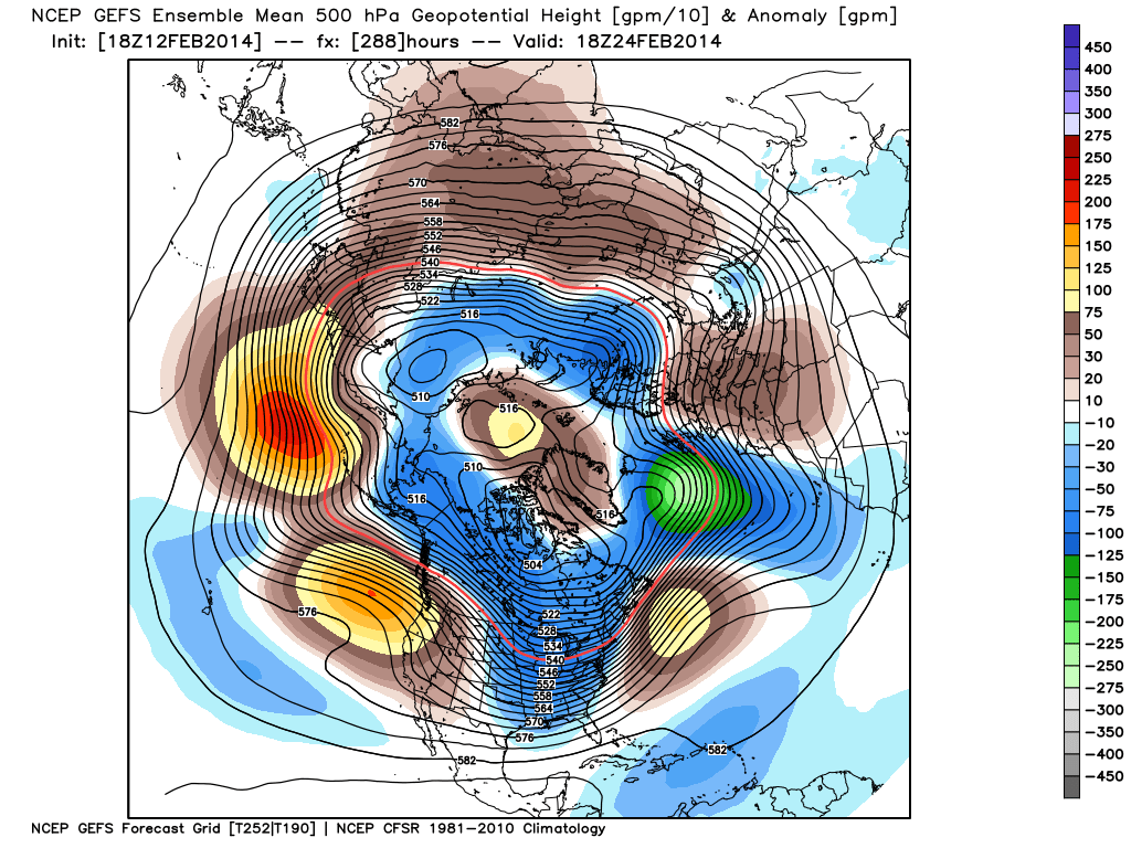
Finally, it should be noted that while a brief “relaxation” of the seemingly unending winter is on the way, the long term pattern continues to suggest a cold and wintry time of things continues overall.  Next week appears to be an “island of warmth in a sea of cold” type pattern.  Latest ensemble data continues to back this idea up.  That’s not saying we’re going to deal with the type of severe cold we’ve seen over the past several weeks, but instead means we’re going to go back below normal as we get set to wrap up February and head into March.

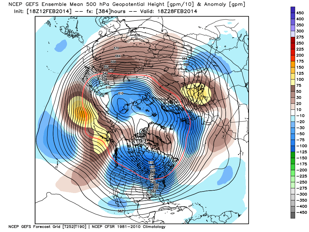
The latest GFS ensembles show the evolution of things well.  The “double secret probation” European model also shows something similar.

gefs_z500anom_nh_33gefs_z500anom_nh_49gefs_z500anom_nh_65

Note the ridge and associated spring “tease” is replaced with a cold and more wintry looking eastern trough rather quickly.  Circle the 24th on your calendar for the potential of a widespread storm system.  Far too early for details or questions, but the pattern looks to produce some busy times around this point.  Before that we have plenty of weather in front of us to deal with… weekend snow opportunities, foggy/ drizzly weather to accompany the initial surge of milder air next week, and a spring tease by late next week!

Historic Snow Season Keeps Rolling Along…

The winter of 2013-2014 is off to a rip-roaring start and, as we’ve discussed in previous posts, the mid to long range data suggests we remain locked in an exceptionally cold and snowy pattern.  Officially, as of this evening, the Indianapolis National Weather Service has posted some impressive stats (the full report can be found here), including:

  • Through Jan. 21st, the 24.4″ of snow ranks as the 3rd snowiest January on record.
  • Through Jan. 21st, the season-to-date snowfall of 33.2″ ranks as the 2nd highest on record in the period Dec. 1st through Jan. 21st.
  • Through Jan. 21st, the season-to-date snowfall of 33.2″ ranks as the 8th snowiest on record for an entire winter season.

As we look ahead to the upcoming 7-10 day period, we note a continuation of arctic reinforcements- each which will be plenty capable of adding to the snowfall total.  Additionally, our cold air mass will only grow even more severe and bitter over time, including multiple days during the aforementioned period where central Indiana will go below zero.  Finally, there have been many questions concerning a potential big storm centered on early February.  I’m not sure where this rumor started, but it’s far too early to say with any sort of confidence any specifics around a possible big winter storm early February.  That said, as we’ll get into briefly below, the pattern does appear to be aligning itself in a way where a widespread winter storm is possible somewhere across the eastern half of the country.

Okay, okay, back to the near term…  Let’s start with tomorrow!  After a cold and dry start to the day, our next arctic front will blow into the region during the evening.  Arctic fronts are notorious for having bursts of heavy snow rates in a scattered fashion and this appears to be the case as the next arctic front moves through Wednesday evening.  We bracket the hours of 5p-8p for the possibility of heavy snow bursts racing through central Indiana.  While these won’t last long, they’ll likely be intense- capable of depositing a quick 1″-2″ of new snow on a gusty northwest wind within 30-60 minutes.  White-out conditions and extremely heavy snowfall rates will accompany the heavier bursts of snow.  Latest high-resolution model data shows the heavy snow bursts accompanying the arctic front tomorrow evening:

hires_ref_indy_31

Thursday will be mostly dry and frigid, but all eyes will then begin to turn to our next significant winter event Friday into Saturday.  The pressure gradient between high pressure across the Mississippi River Valley and the next approaching arctic front (and associated low pressure) will really being to kick up the wind across our region Friday.  We’re afraid we deal with another round of severe blowing and drifting snow Friday, especially Friday afternoon and night.  Areas most suspect to drifting and blowing snow will be central Indiana’s open country and may not be too different from the problems our region dealt with Sunday into Monday morning from blowing and drifting.

As we approach Friday night into Saturday, snow will overspread the region and will likely accumulate to the tune of a “few inches” during this time period.  Strong winds will remain, shifting from the west to the northwest and eventually north.  Open country will remain the prime place for continued severe blowing and drifting problems.

gfs_ptype_slp_east_16

Just as soon as Saturday’s snow systems exits stage right, we turn our attention to potentially another significant snow maker for the second half of the weekend.  Latest model data remains consistent on moving another potent clipper system into our region Sunday, including the GFS and Canadian forecast models.  We still have time to fine tune the precise track of the storm, but just north of the low’s track an additional 3-5″ type snow is possible Sunday.  Note the GFS and Euro in relative agreement on the track of the low, with the Canadian currently a touch further north. We’ll fine tune in the days ahead…  Experience with similar patterns from the past suggests central Indiana should brace for more accumulating snow Sunday.

gfs_ptype_slp_east_22cmc_precip_mslp_east_21

As for the brutal cold, we note multiple pushes of fresh arctic air behind each snow maker.  We currently target Thursday morning, Friday morning, Tuesday morning, next Wednesday morning, and next Friday morning as having the most likely shot at dipping below zero. The “coldest of the cold” likely means Tuesday morning takes the crown, with lows potentially dipping into the double-digit below zero range for central Indiana.  The European forecast model (below) even shows sub-zero temperatures making it as far south as the southern Appalachians.

As we look even longer term, there have been many questions centered on the potential of a big winter storm for early February.  Before we go any further, we want to stress it’s far too early to make any claim of certainty to the above.  That said, there are items we can pick up on to a least “raise an eyebrow” that something of significance may be brewing… Do we mean for anyone to take that verbatim and to the bank?  Absolutely not.

The European Weeklies suggest we need to keep an eye on the first week of February.  They show a potential phasing of the jet (where the northern and southern streams of the jet stream phase together- often times resulting in a big storm)… That said, we want to again stress this is far too early to be discussing with any sort of certainty.  Heh, the next week will keep us busy enough!

Keep the shovel handy!  Snow removal companies, thank you for your service and hard work…hopefully you have plenty of coffee on hand!

Impressive Cold Pattern Looming; Beware Of The Northwest Flow…

We continue to be very impressed with the cold pattern that’s looming.  Even before the warm up and thaw last week, we made mention that the seeds were being planted for a very cold close to December and open to 2014.  Latest data continues to back this idea up.  Additionally, in the longer term, there are some goings on that would suggest we better hunker down for a colder than average January.  While December will finished colder than average, a colder than average January can really hurt the pocket book as “average” temperatures are obviously even colder than December.

Today’s 12z ensembles are locking in on the pattern than can deliver one shot after the other of arctic air in the 8-10 day range.

test8

As for the snow, we still think we need to watch the models around the New Year for the threat of some southern stream energy interacting with the available cold air.  That said, even without the southern stream, one must remain abreast of the challenge that a northwest flow pattern can produce.

Forecast models have a difficult time handling clipper systems in these type of patterns until within 24-48 hours within an event.  Many times what appears to be a rather “harmless” clipper 4-7 days out can suddenly turn much more robust once the model catches onto the track and ability to literally squeeze out any and all available moisture from a cold air mass.  Furthermore, the “normal” 10:1 snow ratio, many like to use, doesn’t apply in the least to these type systems.  In cold environments you can easily get what’s called the “fluff effect” and snow ratios are more in the 20-30:1 range.  Needless to say, it’s a challenging pattern that will keep us on our toes over the coming couple of weeks.

To summarize, we’re extremely confident on a colder than average close to December and open to January.  We’ll have to monitor fast moving clipper systems that modeling will struggle with until right up to the event.  Finally, we’ll keep a close eye on the potential interaction of the southern stream and cold air around the New Year time period for the possibility of a storm of “more significance.” Stay tuned!

A Lot Of Weather To Talk About…

Mother Nature seems determined to put us weather forecasters to hard work as we get set to head into the Christmas season and welcome in 2014.  We’re tracking a major flood situation that will unfold across central Indiana over the upcoming weekend, followed by a reload of the cold and potentially a storm with a more wintry component as we get closer to the New Year.

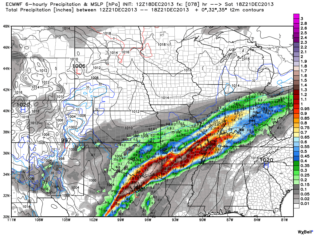
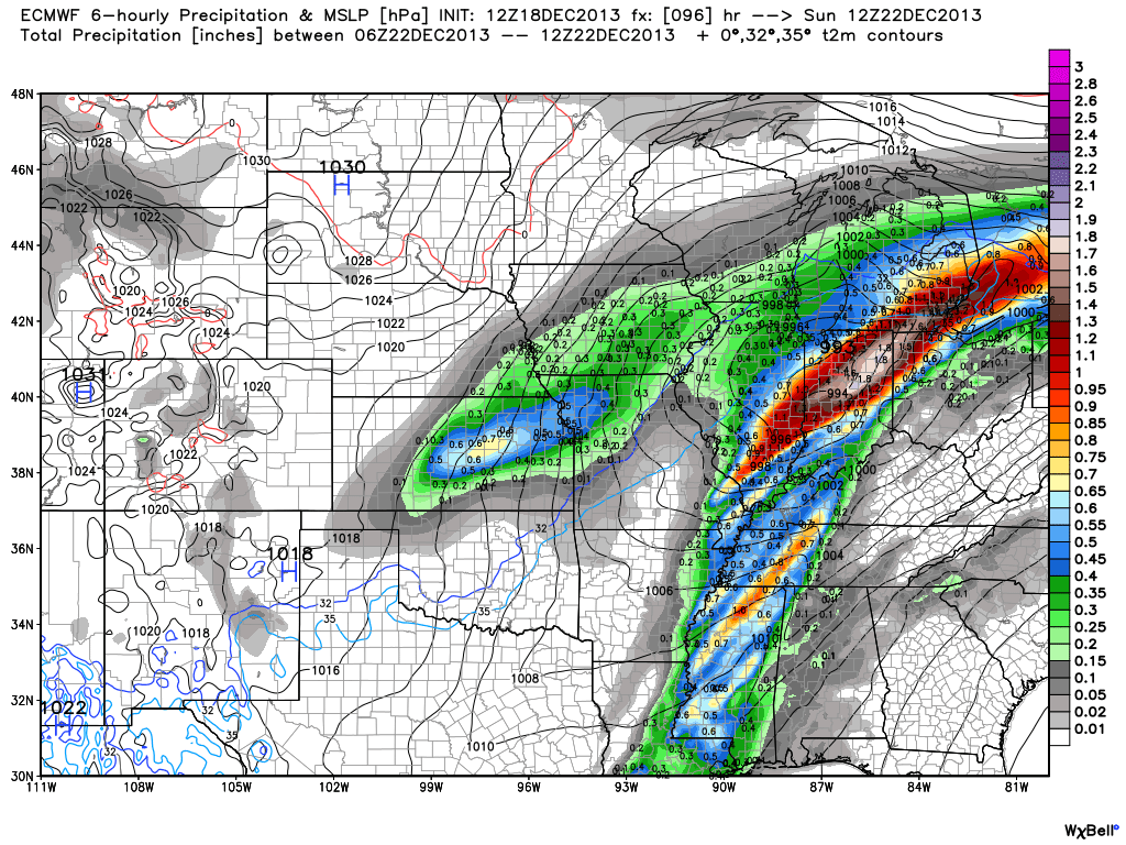
First things first and that’s the significant flood threat in the short-term period.  Without trying to go into scare tactic mode, current model data would result in a downright dangerous flooding event for many low lying and flood prone areas this weekend.  Rainfall numbers are extremely impressive with this event and with a deep tropical connection, widespread 3-4″ totals are certainly likely, including some localized higher amounts.  Note the latest European chart, courtesy of the model suite off Weatherbell Analytics.  Needless to say, the Gulf of Mexico is officially “open for business” and will help contribute to excessive rainfall totals and, as stated above, potentially a dangerous flooding event this weekend across central Indiana.

ecmwf_uvz850_noram_16

Latest numbers averaged off a variety of computer models would place just under 4″ of rainfall down by noon Sunday, most of which falls between Friday and Sunday morning.  We note (2) waves of enhanced rainfall intensity set to impact the region.  As of now we’re targeting Saturday afternoon and again late Saturday night/ Sunday morning for extremely heavy rain, shown below.

ecmwf_slp_precip_mc_14ecmwf_slp_precip_mc_17

We still have time to watch the data and monitor the track of the storm.  It’s possible the “heaviest of the heavy” axis of rain shifts somewhat in the days ahead,  but it’s also important to note that even a light to moderate rain event combined with a frozen ground and a solid snow pack still in place will lead to flooding problems here across central Indiana.  The question of whether or not we’ll deal with flooding here this weekend shouldn’t be asked, but instead the question that remains is just how severe will the flooding be?  Stay tuned and if you live or work in a flood prone area, we would recommend preparing now for flooding.

Now, as we look ahead and focus on the Christmas to New Years period our thoughts will shift from a flood threat in the near term to one that’s more wintry.  We’ll turn dramatically colder Sunday afternoon behind the big rain storm and that will set the stage for a colder-than-average run up to Christmas. In fact, latest raw numbers off some forecast model guidance has some frigid readings ahead next week (upper single digits not ruled out for lows).

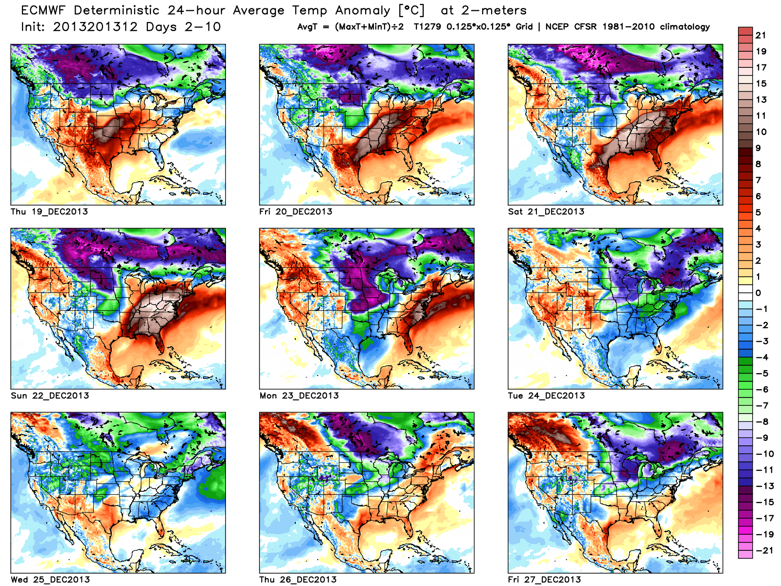
The upcoming 10 days off the European forecast model charts show an interesting scenario with the coming thaw, but the key word is brief.  Note days 6-10 are back into a colder-than-normal regime.

tavg_anom_ecmwf_conus_1

Additionally, we think we’ll have to deal with another storm prior to the New Year period and with the colder air back in place, there’s the threat we could have to contend with a wintry side to the next storm.  The details with storm number two will have to wait until we finish dealing with the first storm and associated serious flood threat it’s presenting.