Category: Long Range Discussion

Where We Are And Where We’re Going…

It’s another frigid start to the day and this seems to be the story of the winter of 2024-2015. The weather roundup of 7am temperatures and March 6th snow cover…

You must be logged in to view this content. Click Here to become a member of IndyWX.com for full access.  Already a member of IndyWx.com All-Access?  Log-in here.

Permanent link to this article: https://indywx.com/where-we-are-and-where-were-going/

Warm Up Coming…

After a long and cold winter, many are excited about hearing of the prospects of a warm up and first true taste of spring.

While the European data has totally bought in to the impressive “spring fling” next week, the GFS isn’t as excited of the potentially warmer times.  Case in point, the GFS and European couldn’t be in more different camps for mid and late next week.  Where the GFS has low/ mid 40s for highs the European has low/ mid 60s for highs.  What’s 20 degrees amongst friends?!

Wild model swings and disagreements are common when pattern changes are taking place.   While we might not get as warm as the Euro. would imply, it’s a safe bet we’ll be considerably warmer than the chilly GFS readings.

Note the AO and NAO strongly positive through the next 10-15 days.  This is the time of the year when these teleconnections can impact our region’s weather in the most significant way.  Both of these are warm signals taken at face value.

3


4


Note the pattern flip to a “flat” ridge by Day 10, indicative of the milder times ahead.

1


However, by Day 15 we notice the Alaskan ridge redeveloping.  This is NOT a signal for warm weather across our part of the region, as the steering currents would tap available cold air and direct it south into the Mid West and Ohio Valley.

1


So, what do we take from this?  We’re going to warm next week without question.  While the extent of the warming is up for debate, the overall milder times for a 5-7 period is a good call at this point.  On the flip side, we’re not ready to buy into the idea that spring is here for good just yet.  The building Alaskan ridge by the end of Week 2 would imply a cold close to March, and potentially continuing into early April.

Another item to keep a close eye on the upcoming 4-6 weeks?  Those NAO and AO signals.  Should they remain predominately positive this time of year then it’ll be exceptionally challenging to get any sort of cold pattern to lock in for more than a day or two.

Permanent link to this article: https://indywx.com/warm-up-coming/

Looking Ahead…

January is off to a colder than average start across a large portion of the country, including the Hoosier state:

ncep_cfsr_noram_t2m_anomThe snow and ice pack has expanded over the past couple of weeks in rather significant fashion:

nsm_depth_2015011205_National

Two storm systems have offered up busy times over the Ohio Valley the past week. Note liquid equivalent numbers the past (7) days- most significant over central Indiana.  Most of this has been in the form of wintry precipitation (snow and ice).

nws_precip_indy_7

A weak weather system may offer up light snow chances mid week.  The high resolution NAM and European print off light snow while other models “see” us mainly dry mid week.

hires_ref_indy_52

The other big story in the short term will be more bitterly cold arctic air (single digits tonight and close to zero Wednesday morning).

While we’ll certainly “warm” compared to the freezer we’ve been in the first two weeks of January, sneaky arctic highs remain on the field and will put a dent in the air masses from reaching unseasonably mild levels for any length of time this weekend and Week 2.  See Friday’s GFS output and the sneaky arctic high north:

gfs_ptype_slp_east_18

The next significant storm system brews around the 20th (give or take a day, or two) and could offer up rain or a more wintry option.  Keep a close eye on the period 01.20 – 01.23.

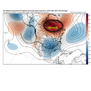
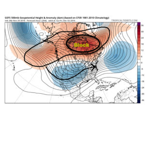
Thereafter, the arctic hounds likely come calling again as the period quickly returns to “lock and load” cold late January into February.  The European and GFS ensembles both show a rebuilding blocking AK ridge and suggest arctic air floods the country yet again as cross-polar flow gets involved:

GFSensembleslateJan

It’s all part of a package that should be the beginning of a colder than average and stormy mid and late winter stretch.  Sea surface temperature anomalies are a textbook setup for a very wintry time of things for our neck of the woods.  Note the Modoki El Nino and warm waters sitting off the PAC NW- both cold/ stormy indicators here:

SSTLateWinterSetUp

Permanent link to this article: https://indywx.com/looking-ahead/

Brrrrr…. Cold Pattern Continues

Many across the Lower 48 are running MUCH colder than average this morning. Take a look a temperature departures from normal this morning: Mind you this is in the face…

You must be logged in to view this content. Click Here to become a member of IndyWX.com for full access.  Already a member of IndyWx.com All-Access?  Log-in here.

Permanent link to this article: https://indywx.com/brrrrr-cold-pattern-continues/

“I’m Dreaming Of A White Christmas…”

Modeling continues to suggest a cold and wintry time lies ahead as we progress into and through the special Christmas period. Could this be the scene across central Indiana Christmas…

You must be logged in to view this content. Click Here to become a member of IndyWX.com for full access.  Already a member of IndyWx.com All-Access?  Log-in here.

Permanent link to this article: https://indywx.com/im-dreaming-of-a-white-christmas/