
You must be logged in to view this content. Click Here to become a member of IndyWX.com for full access. Already a member of IndyWx.com All-Access? Log-in here.
Category: Long Range Discussion
Permanent link to this article: https://indywx.com/active-winter-pattern-in-place/
Jan 14
Busy Period Of Winter Weather…
The overall shift in the weather pattern to one that will produce sustained winter weather threats and below normal air is underway. Before diving into the individual threats that loom…
You must be logged in to view this content. Click Here to become a member of IndyWX.com for full access. Already a member of IndyWx.com All-Access? Log-in here.
Permanent link to this article: https://indywx.com/busy-period-of-winter-weather/
Jan 13
Threat Of Another Major Winter Storm Late Week…
You must be logged in to view this content. Click Here to become a member of IndyWX.com for full access. Already a member of IndyWx.com All-Access? Log-in here.
Permanent link to this article: https://indywx.com/threat-of-another-major-winter-storm-late-week/
Jan 10
VIDEO: Long Range Update; And Looking At This Weekend’s Snow Storm…
Tonight’s video update focuses on the long range and reviews some of the fresh short-term data churning on this weekend’s snow storm.
You must be logged in to view this content. Click Here to become a member of IndyWX.com for full access. Already a member of IndyWx.com All-Access? Log-in here.
Permanent link to this article: https://indywx.com/video-long-range-update-and-looking-at-this-weekends-snow-storm/
Dec 22
Pre-Christmas Weather Rambles…
I. While we certainly aren’t talking about significant weather events between now and Christmas Day, there will be a couple of impulses of upper level energy that may be just strong enough to produce snow showers and flurries at times. We’re tracking (2) weak disturbances that stand a chance to get a couple of snow showers going Sunday evening and again Christmas Day. The one on Christmas, itself, will be a bit stronger and may have a shield of more organized precipitation- likely that would start as wet snow before transitioning to rain before ending.
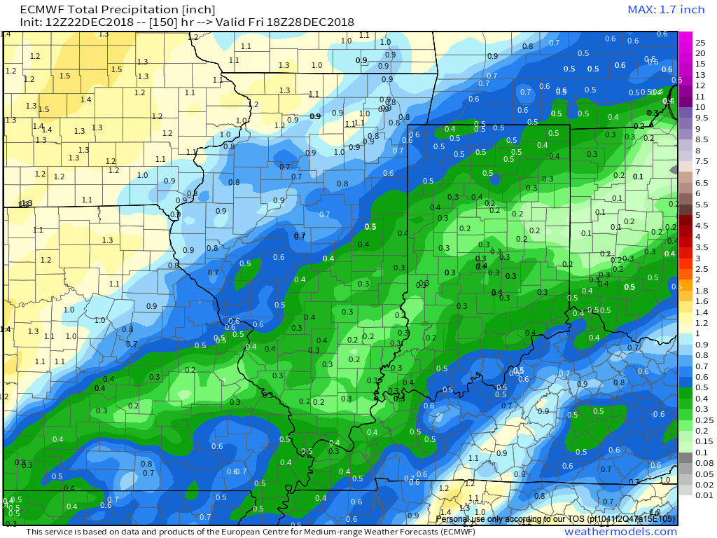
 II. A much stronger storm system will wrap up to our northwest Wednesday night and Thursday. We’ll notice an increasingly strong southerly breeze during this time period and rain will be on the increase as we progress through the day Thursday. The trade-off? Highs between 55° and 60° to close the week- though those temperatures may actually come Thursday evening before cooler air begins to slip in here during the day Friday.

As things stand now, both the GFS and European models, courtesy of Weathermodels.com, aren’t overly excited on rainfall amounts with this storm system, but I think they’ll trend wetter as time goes on. We’ll continue to forecast amounts between 0.50″ and 1″.
 III. All attention is squarely focused on a significant pattern change that takes shape as we head into the new year. As mentioned in previous posts and discussions, the transition is likely to be a stormy one, but it’s far too early to talk precipitation types. A combination of ingredients appears to be aligning to create a colder than normal (and potentially significantly so) pattern at the traditionally coldest time of year (mid-Jan).
In the more immediate term, we note the latest GEFS showcases a classic “horse shoe” block that will favor a wintry regime across the east to open the new year- thanks to Tropicaltidbits.com.

Permanent link to this article: https://indywx.com/pre-christmas-weather-rambles/