VIDEO: Pattern Flips Colder Than Normal, But Can It Last Past Mid-December?
You must be logged in to view this content. Click Here to become a member of IndyWX.com for full access. Already a member of IndyWx.com All-Access? Log-in here.
You must be logged in to view this content. Click Here to become a member of IndyWX.com for full access. Already a member of IndyWx.com All-Access? Log-in here.
You must be logged in to view this content. Click Here to become a member of IndyWX.com for full access. Already a member of IndyWx.com All-Access? Log-in here.
You must be logged in to view this content. Click Here to become a member of IndyWX.com for full access. Already a member of IndyWx.com All-Access? Log-in here.
This morning is once again reminding us that we can deal with wintry “issues” at times even in the midst of an overall mild pattern. As we move down the road, it sure appears as if additional opportunities for wintry weather will present themselves as the pattern evolves towards more of a traditional regime to support such.
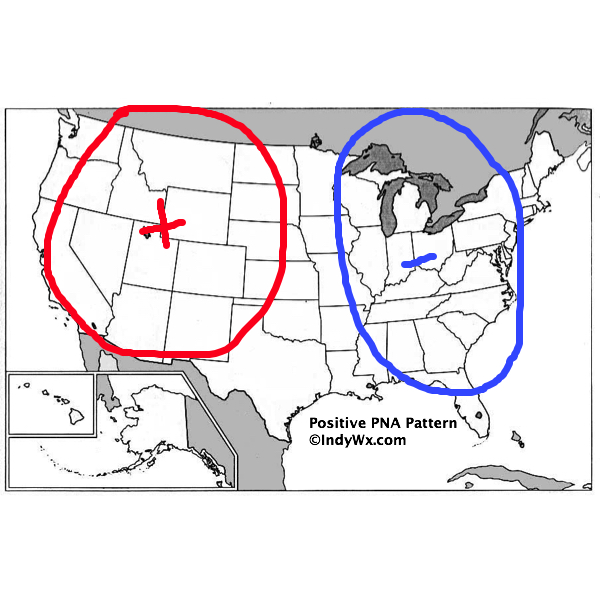
More specifically, we’re targeting the period between 11/30 and 12/10. Though still not a “textbook” pattern, the PNA is trending more positive with each run. This favors as eastern trough (example below).

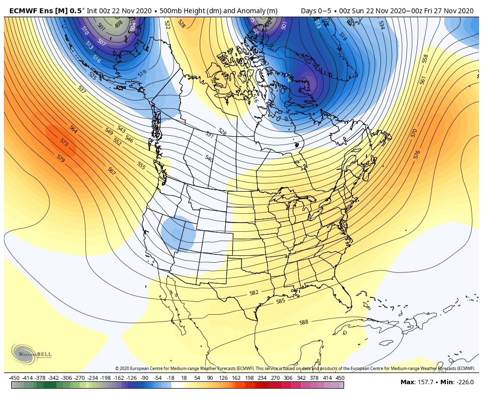
Note how the upper pattern evolves in the coming couple of weeks:
You might be asking yourself, “what would take this pattern to lock-in and become more textbook?” We need the two positives (initially over Saskatchewan and Manitoba to “connect” with the one in the northwestern Atlantic). As it is, we do note the heights continue to build and push towards Greenland. I’m not sure we can pull it off, but the evolution towards a strong PNA can force the issue and eventually lead to a negative AO. Regardless of whether or not we get to that point, which would lead to a more long lasting colder/ stormy regime, I think we’ll have a minimum of 2 opportunities for eastern wintry “fun and games” during the aforementioned period above.
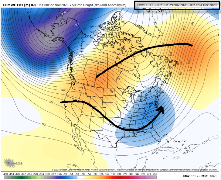
As we get into Week 2 (11/29-12/4), note how the pattern has the look of an active subtropical jet as the “horseshoe” block tries to get established over the top. This is likely still not an overly cold pattern, but one plenty capable of additional wintry fun, even with marginally cold air.
Stay tuned. The closer we get, the more specific we can be regarding the storms. From this distance, if I’m a fan of winter weather, you have to like where you’re sitting as we open up meteorological winter.
As we’re getting set to turn the page into a new season, modeling already agrees that the overall pattern is very much unlike the big “player” on the field (La Nina). While all Nina (as well as Nino and La Nada) events are different and unique, the “average” La Nina pattern is shown below:
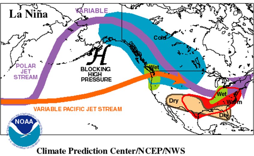
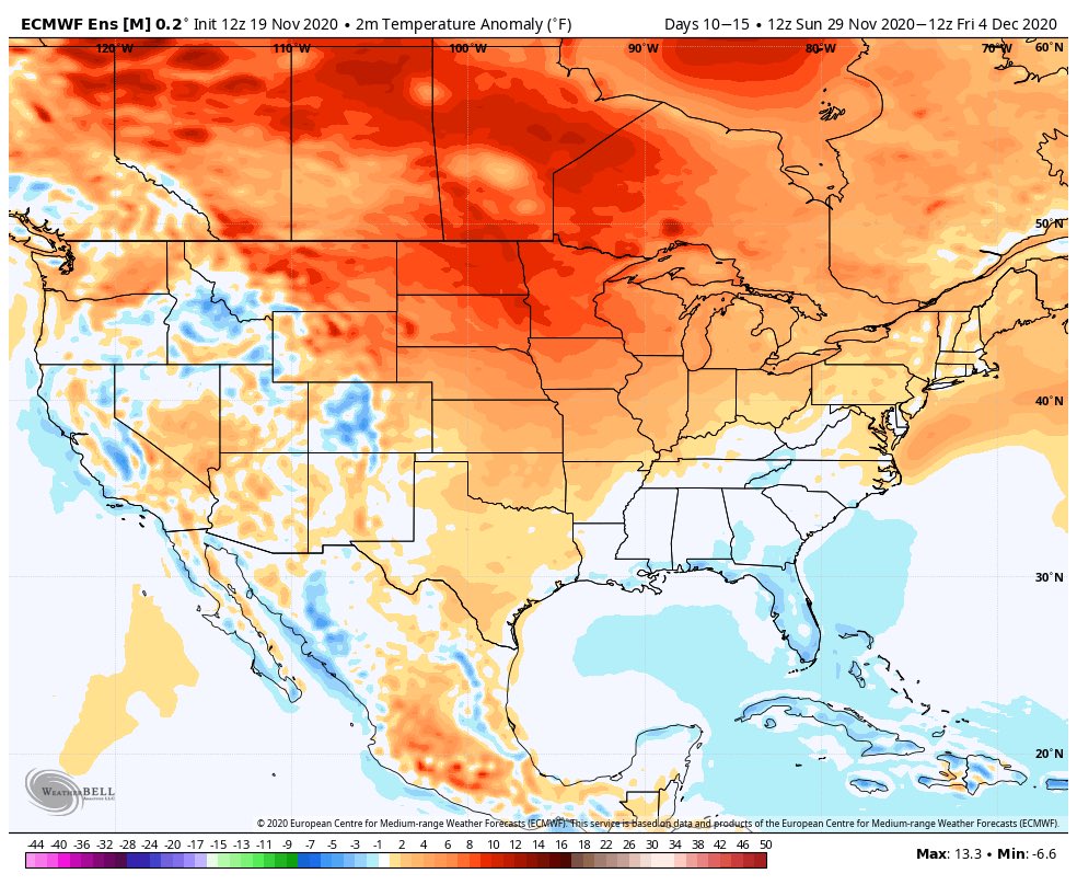
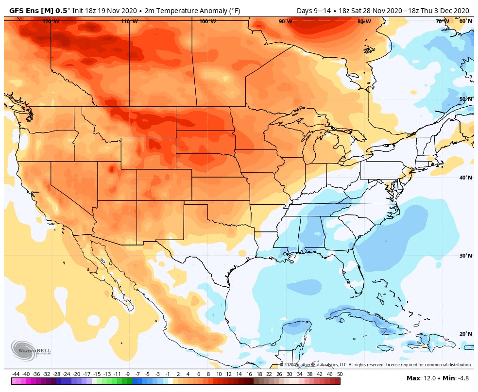
Note both the EPS and GEFS for early December are polar opposite of this traditional La Nina look:
Before we look further at the various data, let’s review the latest teleconnection trends and MJO plots.
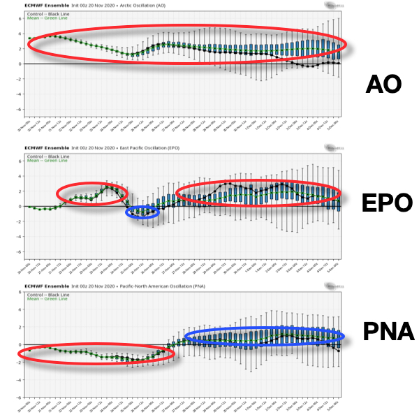
Teleconnections: In short, the consensus is it’ll be hard to drive any sort of sustained cold weather into early December. Note the AO is expected to run positive throughout the upcoming couple weeks, the EPO is mostly positive, as well. The one potential “fly in the ointment” that we’ll continue to keep a close eye on? The PNA and whether or not it continues to trend positive down the road.
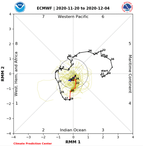
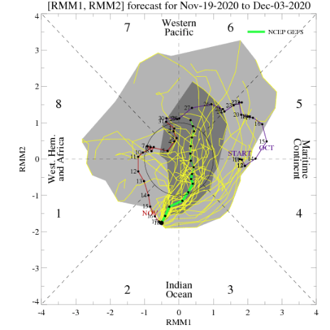
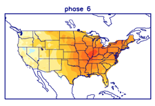
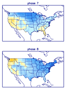
MJO: This is much more problematic as the data disagrees on what takes place down the road. The European products stall things in the null phase (meaning we need to pay more attention to the teleconnection drivers) while the American data seems to want to take things towards Phase 6 by early Dec. This is interesting on multiple fronts. Obviously having to do with the battle between the models, but also whether the amplitude continues down the road. If (big If) the American model wins out, it could mean we swing things into the colder phases towards mid-December. Again, this is a very low confidence forecast and will require a close eye as we move ahead.
Model Data over the next couple of weeks:
CFSv2 Weeklies- warmth dominates over the next few weeks. Note the model sees the wet pattern in the immediate term before drying us out Week 2. Eventually, the wet pattern is shown to return during the Weeks 3-4 time period.
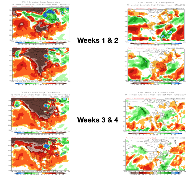
JMA Weeklies- Similar story to the CFSv2 Weeklies above. Warmth dominates, but what we’ll need to look for is the possibility of the model trending cooler “underneath” with time as the warmth builds over the top. While not an overly cold pattern by any means, should this take place, all of the sudden a rather “boring” pattern from a wintry perspective can flip and become more interesting. Note the precipitation pattern is also similar: wet now, drier Week 2, and a return of the more active times Weeks 3-4.

European Weeklies- Not much difference from the other weekly products with a warm look, overall. Similar to the JMA, we’ll need to watch if the warmth continues to build in Canada which would likely result in cooling across a portion of the Lower 48 (most likely Southeast region first) with future updates.
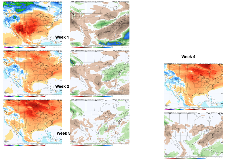
The overall consensus is it’ll be tough to get any sort of long-lasting well below normal airmass between now and Dec. 10. While it looks warmer than normal through the majority of the next couple of weeks, that’s not to say it’s a pattern without challenges, as pointed out above. (Heck, areas of northern IN may deal with wintry precipitation over the weekend). Of greatest interest, personally, is the PNA trend and watching the models “duke it out” with the MJO.