Category: IndySportsReport

Winter Storm Tonight-Saturday

Good morning and happy Friday, friends!  Boy, Old Man Winter is really beginning to turn some minds around from thinking this was an easy winter to one that’s quite impressive, especially from a cold standpoint.  By the way, there’s MUCH more from where this came from!  Essentially we remain on “lock down” for more brutally cold and wintry conditions for the upcoming 7-10 day period.  More on that later.

Here’s a look at our initial snowfall forecast map for tonight and Saturday:

2201522115SnowMapForecast radar shows heavy wet snow encompassing central Indiana Saturday morning:

hires_ref_indy_29Bullet point highlights you need to know:

  • Snow will overspread central Indiana from the southwest between 10p-1a
  • Snow will become heavy at times between 3a-7a
  • Sleet and freezing rain will accumulate significantly downstate
  • Most of the snow will be east of the area by 3p Saturday
  • You’ll want to plow and clean snow up Saturday night as cold air quickly returns Sunday
  • Arctic outbreak next week likely will feature record cold, and colder than this week has been
  • No let-up in sight from this unrelenting winter pattern

Permanent link to this article: https://indywx.com/2015/02/20/winter-storm-tonight-saturday/

3a Sunday Morning…

The initial surge of moisture has, for the most part, come and gone- dropping one half to one inch of snow for many across central Indiana. Overnight computer model data…

You must be logged in to view this content. Click Here to become a member of IndyWX.com for full access.  Already a member of IndyWx.com All-Access?  Log-in here.

Permanent link to this article: https://indywx.com/2015/02/01/3a-sunday-morning/

Crippling Snow Storm For Some; Just Wet For Others.

An incredibly difficult and challenging forecast is in store for central Indiana over the course of the next 24-36 hours.  I want to get out front with this right from the get go: bust potential is high with this type set-up, as a jog 10-20 miles north or south of the surface low will mean the difference between half a foot of snow and plain cold rain.  As it stands now, and after careful consideration of every piece of data available, here’s our updated snowfall map:

SnowfallMap2115V2


I still am not sure any one piece of data is handling the interaction between the arctic high to the north and the developing low to our southwest “perfectly.”  As such, additional fine tuning will have to take place tonight.  That arctic high is powerful at nearly 1045mb.  From a meteorological standpoint, it’ll be a fascinating battle watching the fight play out.

As you can see, we’re going to be looking at a very tight thermal gradient and it, unfortunately, appears to set itself up directly over the I-70 corridor.  Precipitation type and amounts are the biggest challenge within the I-70 corridor.  Further north, confidence increases rather significantly for a crippling snow storm.  For central Indiana, this will be a very wet and heavy snow event before ending as a drier, powdery snow on the back end.  As winds increase Sunday afternoon/ evening, the heavy “paste” like snow won’t blow around as easily as it would if it was drier.  Further north the snow consistency will be drier and blowing and drifting will be severe (in the 8″-12″+ zone).

In the shorter-term, rain and a wintry mix will arrive into the region as early as early as 6-7 o’clock.

Stay tuned.  Another post will hit here late tonight (midnight-ish).  In the meantime, we’ll keep our thoughts coming at @indywx through the afternoon.

Permanent link to this article: https://indywx.com/2015/01/31/crippling-snow-storm-for-some-just-wet-for-others/

Fresh Arctic Air Inbound; Winter Storm Potential Sunday Night-Monday.

Tonight’s video update discusses the heavier burst of snow inbound, fresh arctic air/ dangerous wind chill values Friday, and takes a look at more “wintry mischief” brewing for late in…

You must be logged in to view this content. Click Here to become a member of IndyWX.com for full access.  Already a member of IndyWx.com All-Access?  Log-in here.

Permanent link to this article: https://indywx.com/2015/01/08/fresh-arctic-air-inbound-winter-storm-potential-sunday-night-monday/

Dangerous Cold; More Snow Ahead Thursday And Eyeing Sunday-Monday…

Tonight’s video update focuses on the dangerous cold, more accumulating snow Thursday afternoon, and looks ahead to another winter event looming Sunday night and Monday.

Your latest snowfall forecast brought to you by the fine folks at indysportsreport.com:

1815Snow

Permanent link to this article: https://indywx.com/2015/01/07/dangerous-cold-more-snow-ahead-thursday-and-eyeing-sunday-monday/

Cold With Developing Snow For Colts v. Bengals

Colts v. Bengals Forecast Prepared For:
The Indiana Sports Report
01.04.14

Happy game day Colts fans and welcome to the start of the 2015 NFL Playoffs! (Hard to believe)! Today will feature quite a few weather changes when we compare this morning to tonight, but the main message we want to pass along is “get ready for winter!” While temperatures this morning are relatively mild, readings will fall rapidly this afternoon and we forecast left over moisture to transition to light snow and snow showers this afternoon into the evening. Additionally, winds will be strong and gusty. Tailgaters should prepare for cold conditions with rain showers mixing with and transitioning to snow by afternoon. Bundle up and GO COLTS!

Tailgate Weather

Kickoff Weather

Heading Home

Light rain mixing with light snow Snow showers and windy Snow showers and windy
Temp: 32-35 Temp: 32-35 Temp: 24-27
Wind:  SW 10-20 MPH Wind: W 10-20 MPH Wind: NW 15-25 MPH
Precip: 0.05” Precip: Trace Precip: 0.50”

ISRlogo2-280x121

Permanent link to this article: https://indywx.com/2015/01/04/cold-with-developing-snow-for-colts-v-bengals/

Mild; Foggy With Areas Of Drizzle For Colts Vs. Texans

Colts v. Texans Forecast Prepared For:

The Indiana Sports Report

12.14.14

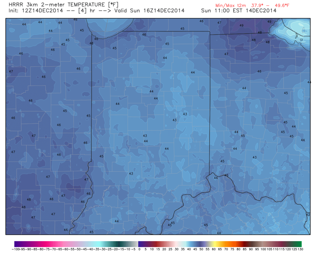
Happy game day Colts fans!  – New day; same story…central Indiana will remain under the influence of an “inversion” and this will keep low clouds and areas of fog prevalent for most of the day.  Milder air in the 50s at 4,000-5,000 feet up is overrunning shallow cooler air that’s trapped at the surface and the result in more of the same- gloomy, cloudy, foggy weather.  While temperatures won’t be as mild as they could be without the inversion, tailgaters still can’t complain about 45-50 degree air this time of year :-).  Visit IndyWx.com for “Indy’s Behind The Scenes Weather” all season long!  Go Colts!

Tailgate Weather

Kickoff Weather

Heading Home

Cloudy and foggy; patchy drizzle Cloudy with areas of fog; patchy drizzle Cloudy with areas of fog; patchy drizzle
Temp: 41-45 Temp: 46 Temp:  50
Wind:  S 5-10 MPH Wind: S 5-10 MPH Wind:  S 5-10 MPH
Precip: Trace Precip: Trace Precip:  Trace
Despite low clouds and areas of drizzle, temperatures will be mild this morning for tailgaters!

Despite low clouds and areas of drizzle, temperatures will be mild this morning for tailgaters! 

ISRlogo2-280x121

Permanent link to this article: https://indywx.com/2014/12/14/mild-foggy-with-areas-of-drizzle-for-colts-vs-texans/

Warm And Windy For Colts Vs. Redskins…

Colts v. Redskins Forecast Prepared For:

The Indiana Sports Report

11.30.14

Happy game day Colts fans!  A strong southwesterly air flow is creating windy conditions for tailgating this morning, but the upside is that temperatures are in the lower 60s!  A cold front has it’s eyes set on the region and will arrive this afternoon and evening.  This will lead to better afternoon rain chances and a MUCH colder feel as we progress through the evening.  Visit IndyWx.com for “Indy’s Behind The Scenes Weather” all season long!  Go Colts!

Tailgate Weather

Kickoff Weather

Heading Home

Mostly Cloudy Scattered Showers Showers
Temp: 61-64 Temp: 61 Temp:  60
Wind:  SW 20-30 MPH Wind: SW 20-30 MPH Wind:  SE 20-30 MPH
Precip: 0.00” Precip: 0.05”  Precip:  0.05”
Scattered showers will arrive around kickoff, but heavier showers should hold off until the cold front moves in later this evening, per this forecast radar image.

Scattered showers will arrive around kickoff, but heavier showers should hold off until the cold front moves in later this evening, per this forecast radar image.

ISRlogo2-280x121

Permanent link to this article: https://indywx.com/2014/11/30/warm-and-windy-for-colts-vs-redskins/

IndySportsReport.Com Colts Game Day Forecast

Colts v. Jaguars Forecast Prepared For:

The Indiana Sports Report

11.23.14

Happy game day Colts fans!  A significant autumn storm system will lift north out of the southern region today into the Great Lakes Monday.  This surface low will deepen as it pushes north and be responsible for a wet and windy Sunday afternoon.

Early tailgating should feature overcast skies along with an isolated shower (most, if not all, of the pregame should be rain-free).  Best rain chances will arrive after kick off and feature embedded thunder, as well.  Certainly plan on a wet commute home.  Visit IndyWx.com for “Indy’s Behind The Scenes Weather” all season long!  Go Colts!


Tailgate Weather

Kickoff Weather

Heading Home

Cloudy Cloudy Heavy Rain
Temp: 53-58 Temp: 58 Temp:  57
Wind:  SE 10 MPH Wind: SE 10 MPH Wind:  SE 10-15 MPH
Precip: 0.00” Precip: 0.00” Precip:  0.50”
Heavy rain will lift out of the south this afternoon. Forecast radar 2pm:

Heavy rain will lift out of the south this afternoon. Forecast radar 2pm:

Permanent link to this article: https://indywx.com/2014/11/23/indysportsreport-com-colts-game-day-forecast/

Cold IndySportsReport.com High School Football Forecast…

Good morning and happy Friday! We’re dealing with more unseasonably cold weather today which will result in needing the heavier coats and winter attire tonight as you head off to…

You must be logged in to view this content. Click Here to become a member of IndyWX.com for full access.  Already a member of IndyWx.com All-Access?  Log-in here.

Permanent link to this article: https://indywx.com/2014/11/21/cold-indysportsreport-com-high-school-football-forecast/

IndyWx.com