Category: Heavy Rain

Unseasonably Cool Close To The Work Week; Stormy Weekend Awaits…

Thr.

Fri.

Sat.

Sun.

Mon.

Tue.

Wed.

 Status-weather-clouds-icon

 Status-weather-clouds-icon

 Status-weather-storm-night-icon

 Status-weather-storm-night-icon

 Status-weather-clouds-icon

 Status-weather-clouds-icon

 Status-weather-clouds-icon

56/ 77

54/ 80

66/ 88

67/ 87

56/ 69

51/ 72

49/ 77 

– – –

– – –

0.25″-0.50″

0.25″-0.50″

– – –

– – –

– – –

We’re wrapping up the work week with yet another push of unseasonably cool, dry air in place along with plentiful sunshine- another fall preview!  The summer conditions we’ve enjoyed this year are more typical of those our neighbors across MI and WI expect.  Humidity and warmth will build over the weekend and this will be coupled with a couple rounds of strong to potentially severe thunderstorms.  We’ll have to fine tune timing as we move forward, but right now we’re focused on Saturday morning and again Saturday night into Sunday morning.  The Storm Prediction Center outlines our region for a Slight Risk of severe weather Saturday- highlighted by a damaging wind threat.  Weekend rainfall potential sits in the half inch to one inch range, but we also want to be sure to point out there will be locally heavier totals where the stronger storms track.  Once to next week, reinforcing cool, fall-ish, air will blow into town amidst gusty northerly winds.

Permanent link to this article: https://indywx.com/2014/07/24/unseasonably-cool-close-to-the-work-week-stormy-weekend-awaits/

Periodically Stormy Weekend Before Autumn In July

Sat.

Sun.

Mon.

Tue.

Wed.

Thr.

Fri.

 Status-weather-showers-day-icon

 Status-weather-showers-day-icon

 Status-weather-showers-day-icon

 Status-weather-clouds-icon

 Status-weather-clouds-icon

 Status-weather-clouds-icon

 Status-weather-clouds-icon

64/ 83

70/ 85

62/ 80

51/ 68

49/ 72

52/ 74

57/ 79 

Light

Light

Light

– – –

– – –

– – –

– – –

Showers and thunderstorms sit just west of the state line as of this forecast update. These showers and storms will likely hold together as they cross into Indiana and approach central parts of the state late morning and early afternoon.  While these aren’t severe, some localized heavy rain and vivid lightning can be expected in spots. We’ll also keep an eye on storm chances Sunday and Monday. While everyone won’t see heavy rainfall this weekend (around half an inch on average for the region), some localized spots can expect amounts between 1-2″ where heavier storms occur.  The biggest story of this update will be the unseasonably cool air that blows in behind the front Monday night. This will set up a fall-like feel as we progress through next week.

Permanent link to this article: https://indywx.com/2014/07/12/periodically-stormy-weekend-before-autumn-in-july/

Not Much Hot Air In Sight…

The search for that first 90 degree day will have to go on (and on and on and on…) as the pattern remains one that will continue to make it very difficult for any sort of long-lasting, sustained, heat.  In fact, we’re actually going to trend temperatures even cooler as we move into Week 2- the exact opposite of what you’d come to expect as we rumble into mid to late July.

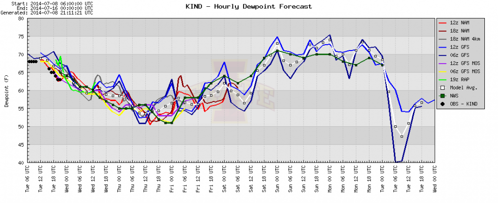
Before we get into next week, let’s focus on the shorter term.  Drier air is on our doorstep as a cold front sweeps central Indiana this evening. This will set the stage for a very pleasant mid week stretch, including temperatures that remain below average and dew points that fall into the 50s.  Note the latest dew point plot below, indicating dew points falling into the 50s, and remaining there for the better part of the next (3) days:

plotter

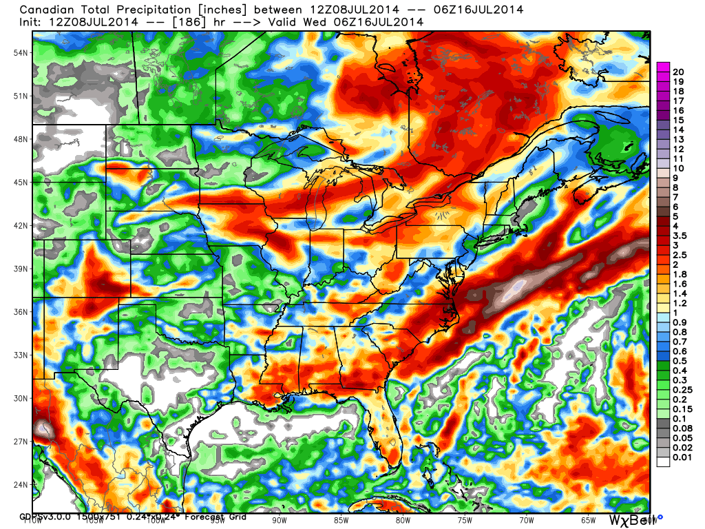
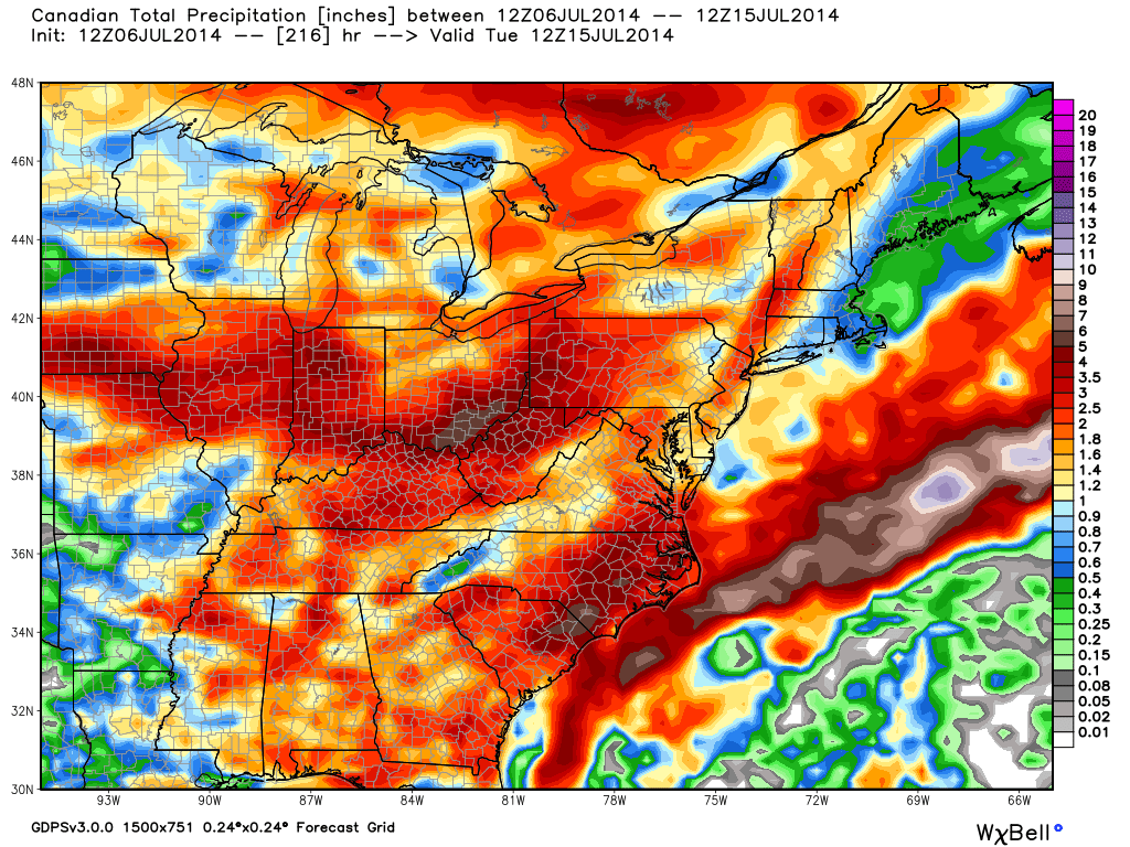
We will turn much more humid (oppressively so) over the weekend and this will help aid in thunderstorm development over the weekend.  Most of the region can expect around an inch of rain, on average, between Friday night and Tuesday, mostly thanks to complexes of thunderstorms.  However, there will be locally heavier totals exceeding 2″ in spots.

cmc_total_precip_east_32

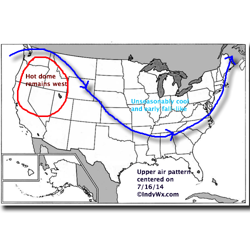
A MUCH stronger front will sweep the state Tuesday and result in temperatures and weather conditions that are much more fall-like than summer.  A couple days next week have the potential to remain in the 60s for highs (centering on Tuesday-Wednesday for that as of now) and overnight lows could dip into the middle 40s to near 50.  Breezy north and northwest winds can also be anticipated. – Certainly far from what you’d expect for this time of year!

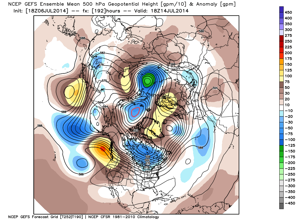
Here’s what the upper air pattern will look like next week:

UAPattern71614

Permanent link to this article: https://indywx.com/2014/07/08/not-much-hot-air-in-sight/

Fresh Air Set To Return…

Tue. Wed. Thr. Fri. Sat. Sun. Mon.               66/ 80 61/ 77 56/ 78 58/ 82 64/ 86 67/ 83 64/ 86  Moderate –…

You must be logged in to view this content. Click Here to become a member of IndyWX.com for full access.  Already a member of IndyWx.com All-Access?  Log-in here.

Permanent link to this article: https://indywx.com/2014/07/08/fresh-air-set-to-return/

Here We Go Again…

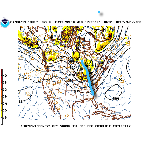
What a weather year this has been for central Indiana.  Snow and cold translated to wet and stormy as winter turned to spring.  Now as summer rumbles into the supposed “dog days” we’re really left with the exact opposite.  Our weather pattern will be dominated by a fast moving northwest flow over the upcoming (7) days and this spells an active and stormy open to the work week and next weekend, with an “island” of cool, pleasant weather thrown in the mix Wednesday through Friday.

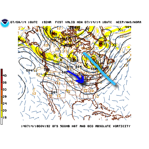
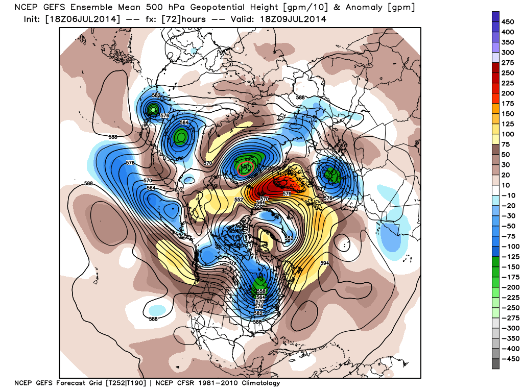
The GFS operational run shows that we’ll remain locked into the rather active northwest flow pattern through the upcoming week.  Note that while the trough axis moves east with time, the northwest flow remains intact.

1


2


There’s excellent ensemble support from the GEFS and EC, as well.

a

b

The end result is a (7) day stretch that remains cooler than normal when all added up, highlighted by the cooler punch of air (worthy of open windows yet again) Wed-Fri.

4

This also remains quite the active pattern in regards to thunderstorm complexes and rounds of locally heavy rainfall.  We bracket late tonight into Monday morning and again Monday night into Tuesday, followed by next weekend for possible storm complexes that will make for a rather noisy time of things here.  As for the severe threat, we’ll have to keep a close eye on each complex.  It’s possible one or two of these could pose a damaging wind threat as they race southeast and that’s our biggest concern as of now.

When you total it all up, the upcoming (7) day period, July 7th-14th, is likely to lead to more significant rainfall over the region.  The Canadian isn’t holding back, suggesting widespread 2-3″ totals.  That may be a bit “bullish,” but we’ll forecast 1.5″-2″ with ease during the upcoming week, including locally heavier totals.

5

Quick summary:

Monday through Tuesday will be highlighted by rainy and stormy periods before we introduce a much cooler and drier regime Wednesday through Friday.  Humidity builds over the upcoming weekend with additional rain and thunderstorm chances returning.

Permanent link to this article: https://indywx.com/2014/07/06/here-we-go-again-2/

Busy Week Of Weather Ahead…

Sun. Mon. Tue. Wed. Thr. Fri. Sat.               62/ 83 66/ 83 70/ 81 61/ 78 52/ 75 54/ 81 62/ 83  Light Light…

You must be logged in to view this content. Click Here to become a member of IndyWX.com for full access.  Already a member of IndyWx.com All-Access?  Log-in here.

Permanent link to this article: https://indywx.com/2014/07/06/busy-week-of-weather-ahead/

Sun-Filled And Unseasonably Cool…

Fri.

Sat.

Sun.

Mon.

Tue.

Wed.

Thr.

 Status-weather-clear-icon

 Status-weather-clear-icon

 Status-weather-clouds-icon

 Status-weather-showers-day-icon

 Status-weather-showers-day-icon

 Status-weather-showers-day-icon

 Status-weather-clouds-icon

51/ 76

55/ 80

59/ 83

68/ 87

68/ 82

58/ 78

57/ 82 

– – –

– – –

– – –

Light

Moderate

Light

– – –

Happy Independence Day!  Canadian high pressure remains firmly in control of our weather today and for the majority of the weekend for that matter.  As a result, look for plentiful amounts of sunshine and temperatures that will continue the cooler than normal regime we enjoyed Thursday.  Today’s conditions, once again, will have that feeling of early fall.  ENJOY!  A more active weather pattern will return early next week as we potentially have to deal with a couple thunderstorm complexes in the Monday-Tuesday time period.  Heavy rain and the chance of severe weather will return to your forecast Monday night into Tuesday and we’ll have more details around this as we move closer.  A cooler and drier regime will build in by the middle portion of next week.

Permanent link to this article: https://indywx.com/2014/07/04/sun-filled-and-unseasonably-cool/

Fall-ish Feel…

Thr. Fri. Sat. Sun. Mon. Tue. Wed.               58/ 73 51/ 76 53/ 80 59/ 83 68/ 86 66/ 83 65/ 81  Light –…

You must be logged in to view this content. Click Here to become a member of IndyWX.com for full access.  Already a member of IndyWx.com All-Access?  Log-in here.

Permanent link to this article: https://indywx.com/2014/07/03/fall-ish-feel/

Winds Of Change On Our Doorstep…

Wed. Thr. Fri. Sat. Sun. Mon. Tue.               65/ 77 58/ 73 51/ 76 52/ 80 59/ 83 65/ 87 70/ 83  Light –…

You must be logged in to view this content. Click Here to become a member of IndyWX.com for full access.  Already a member of IndyWx.com All-Access?  Log-in here.

Permanent link to this article: https://indywx.com/2014/07/02/winds-of-change-on-our-doorstep/

Not Out Of The Woods Just Yet…

Tue. Wed. Thr. Fri. Sat. Sun.  Mon.               66/ 86 65/ 77 58/ 73 51/ 76 52/ 80 59/ 83 64/ 87  Light Light…

You must be logged in to view this content. Click Here to become a member of IndyWX.com for full access.  Already a member of IndyWx.com All-Access?  Log-in here.

Permanent link to this article: https://indywx.com/2014/07/01/not-out-of-the-woods-just-yet/

IndyWx.com