Category: Heavy Rain

Dry Weather Continues For Now…

Screen Shot 2015-10-21 at 9.55.29 PMHighlights:

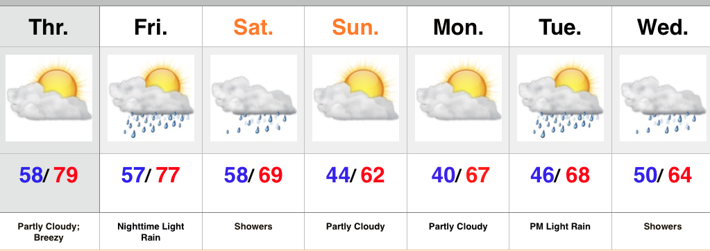
  • Dry, warm, and breezy in the short term
  • Weekend rain chances
  • Better rain chances next week

The ups and downs of fall continue.  It was only a few days ago temperatures were in the 20s and widespread frost and freeze conditions were felt across central IN.  Flip forward to Thursday and some neighborhoods will flirt with the 80 degree mark with a gusty SW wind in place.  Dry weather will continue through the daytime Friday before we introduce shower chances Friday night.  Rain chances continue Saturday.

A cold front will sweep through the area Saturday night and provide a more fall-like feel for the second half of the weekend with increasingly sunny skies as the day progresses.

Our next weather maker will come in the form of a cold front the middle of next week and enough Gulf of Mexico moisture may get entrained into the system to present a better threat of more significant rains than what we’ve seen over the past month, or so.  We’ll keep our fingers crossed.  Model solutions as of now vary from an absolute deluge (GEM and European) to more of a 0.5″-1″ type event.  For now, we’ll “split the difference.”

Upcoming 7-Day Rainfall Forecast: 1″ – 1.5″

Permanent link to this article: https://indywx.com/2015/10/21/dry-weather-continues-for-now/

Weekly Highlights: Action Out West…

Highlights10051011There’s a whole slew of new products we’re going to start rolling out over the next several weeks, including more videos, as well. One of the new features is a nationwide weekly highlight map, helping showcase the big-ticket weather items that have our attention over the upcoming week. While we could side with going with fancy graphics, we chose to go the route of a hand drawn map for old time sakes. 🙂 This will be posted on Sunday or Monday of each week.

1.)  The upper low associated with the catastrophic flooding in SC will continue to slowly pull away from the area as we progress into Tuesday.  Our thoughts and prayers remain with the fine folks of South Carolina as recovery and clean up begins.  Hard to believe areas of SC were in a significant drought as soon as last week.  Those exact same areas have received as much as 25″-30″ of rain over the past 72 hours.  Simply amazing stuff.

2.)  A series of storm systems will clip the Pacific Northwest with heavy rain and wind as the week progresses- particularly mid week into the weekend.

3.)  A storm system and significant moisture will move through the Four Corners region and into western Texas Wednesday into the weekend.  Heavy rain and localized flooding will result.

4.)  A cold front will move through the Mid West later this week with showers and embedded thunder, along with cooler air for the weekend.

As always, you can follow us on Twitter (@indywx) or e-mail us at bill@indywx.com for more on the variety of weather consulting we provide. Have a great day and God Bless!

Permanent link to this article: https://indywx.com/2015/10/05/5408/

Monday Weather Notebook…

October has started off on a dry, cool note. Note the 200%+ anomalies along the eastern seaboard in association with the Nor Easter.     Our thoughts and prayers remain with…

You must be logged in to view this content. Click Here to become a member of IndyWX.com for full access.  Already a member of IndyWx.com All-Access?  Log-in here.

Permanent link to this article: https://indywx.com/2015/10/05/monday-weather-notebook-3/

Rain Today; Windy And Much Cooler Times Ahead…

Screen Shot 2015-09-29 at 7.04.40 AMHighlights:

  • Rainy weather today
  • Much cooler conditions coming
  • Prolonged stretch of strong winds

The region will be under a squeeze play of sorts today as tropical moisture continues to lift north from the Gulf Coast and a cold front approaches from the northwest.  The end result will be for an expanding shield of rain to encompass a large portion of central IN as the day progresses.  Heaviest rainfall is still expected downstate, but there will also be some localized heavier totals across central IN, as well.  This, of course, is much needed.

The cold front will pass tonight and shut off any threat of rain.  The big story will become the much cooler air mass settling into the region for the foreseeable future.  Additionally, factor in the goings on along the eastern seaboard with an area of high pressure building in from the north and very windy conditions can be expected as we move through late week into the weekend.  Strong and gusty northeast winds will be very persistent, with gusts up to 30 MPH at times.

We’ll continue to keep close tabs along the happenings along the eastern seaboard late in the period.  As of now we think high pressure should keep us dry and cool, but stay tuned.

Upcoming 7-Day Rainfall Forecast: 0.50″-1″

Permanent link to this article: https://indywx.com/2015/09/29/rain-today-windy-and-much-cooler-times-ahead/

Weekly Highlights: Tropical Weather Headlines…

Highlights928104There’s a whole slew of new products we’re going to start rolling out over the next several weeks, including more videos, as well.  One of the new features is a nationwide weekly highlight map, helping showcase the big-ticket weather items that have our attention over the upcoming week.  While we could side with going with fancy graphics, we chose to go the route of a hand drawn map for old time sakes.  🙂 This will be posted on Sunday or Monday of each week.

1.) A cold front will move through the Mid West and Ohio Valley during the early to middle portion of the work week and be responsible for putting a temporary delay in #harvest15.  While rainfall won’t be particularly heavy, it’ll help to serve up a fresh chill to the air as we progress from mid to late week.  A significant temperature reversal can be expected from 10-15 degrees above normal to 10 degrees below normal from early week to late week.

2.)  A tropical disturbance is plaguing the Gulf Coastal waters with rough surf, gusty winds, and heavy rain to open the week.  As this disturbance moves northeast, heavy rains will encompass a large portion of the southeast, as well as southern and central Appalachians, on up the eastern seaboard.

3.)  Perhaps of more importance is the way things evolve over the coming couple days with TD 11 and the overall weather pattern off the eastern seaboard.  If you live along the East Coast, you’ll want to pay particularly close attention to the goings on.  At the very least, an impactful system is ahead from a heavy rain and erosion perspective, but there’s also the potential of something more severe from a purely tropical stand point.

4.)  An area of low pressure will drop south along the Front Range late in the period and offer up beneficial moisture to not only the Front Range, but the central Plains.

As always, you can follow us on Twitter (@indywx) or e-mail us at bill@indywx.com for more on the variety of weather consulting we provide.  Have a great day and God Bless!

Permanent link to this article: https://indywx.com/2015/09/28/weekly-highlights-tropical-weather-headlines/

Thursday Weather Notebook…

Another sunny day: This morning’s satellite shows that we’re going to be looking at another mostly sunny and pleasant day across the region. Humidity remains lows for now so it’ll…

You must be logged in to view this content. Click Here to become a member of IndyWX.com for full access.  Already a member of IndyWx.com All-Access?  Log-in here.

Permanent link to this article: https://indywx.com/2015/09/17/thursday-weather-notebook-3/

Summer Isn’t Letting Go…

Screen Shot 2015-09-01 at 9.42.32 PMHighlights:

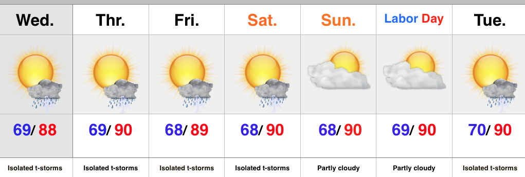
  • Isolated slow moving storms
  • Hot and humid air mass remains
  • Stagnant pattern

An upper level disturbance will push slowly east into Ohio Wednesday, but will remain close enough to have some impact on our local weather.  Coverage of storms won’t be as widespread as those of today, but we’ll likely see a few slow moving, strong storms develop across central IN all the same.

We’ll maintain mention of isolated storms into the weekend, but the big weather story will be the unseasonably hot and humid air mass in place.  It’s all part of the big weather picture that includes a strengthening high pressure ridge (hot dome) over the Lakes and SE Canada as we rumble into the long holiday weekend.

Looking ahead, there are indications that more active times are around the corner once to mid month.

Upcoming 7-Day Rainfall Forecast: 0.25″ – 0.50″ (locally heavier totals)

Storms rumbled across portions of central IN today, but the “@cryptics cam” caught a glorious sunset from Danville this evening.

Permanent link to this article: https://indywx.com/2015/09/01/summer-isnt-letting-go/

Better Coverage Of Storms Tuesday…

Screen Shot 2015-08-31 at 10.09.29 PMHighlights:

  • Better coverage of Tuesday storms
  • Splash and dash storms through the rest of the week
  • Hot pattern continues into the holiday weekend

An upper level disturbance will track overhead Tuesday and be responsible for helping kick off more widespread showers and thunderstorms.  These will be slow movers and capable of depositing hefty rainfall totals in localized areas.  This won’t be a “uniform” rain event by any stretch of the imagination and some locales may not even see a drop of rain.

Coverage of showers and thunderstorms will diminish to “isolated” for mid and late week.  The big weather story will be the unseasonably warm regime leading into the holiday weekend.  Our next storm of note appears to be on the horizon around a week from today and deliver better rain and storm chances by next Tuesday, along with cooler air.

Upcoming 7-Day Rainfall Forecast: 0.10″ – 0.25″ (locally heavier totals)

Permanent link to this article: https://indywx.com/2015/08/31/better-coverage-of-storms-tuesday/

Monday Weather Notebook…

Cool August:    Despite the warm close to August, the month, as a whole, has been cooler than average across the Plains, Ohio Valley, and Tennessee Valley. Heat Expands:   …

You must be logged in to view this content. Click Here to become a member of IndyWX.com for full access.  Already a member of IndyWx.com All-Access?  Log-in here.

Permanent link to this article: https://indywx.com/2015/08/31/monday-weather-notebook-2/

Wednesday Weather Notebook; Strong Storms Still Possible…

A significant late summer cold front will move into the warm and humid air mass currently in place later tonight. This time tomorrow will feel mighty different outside with a…

You must be logged in to view this content. Click Here to become a member of IndyWX.com for full access.  Already a member of IndyWx.com All-Access?  Log-in here.

Permanent link to this article: https://indywx.com/2015/08/19/wednesday-weather-notebook-strong-storms-still-possible/

IndyWx.com