Category: Heavy Rain

Heavy Rain Continues; Early Fall Preview Late Next Weekend…

Screen Shot 2016-08-14 at 9.57.05 AMHighlights:

  • Periods of heavy rain
  • Drying out come mid week
  • Cold front arrives next weekend

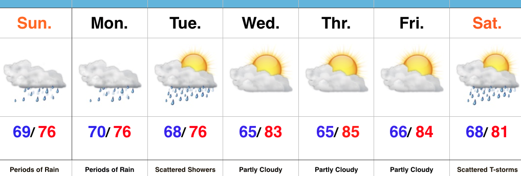
Flooding Concerns…Renewed heavy rain is pushing through central IN as we write up the morning forecast package.  This conveyor belt of moisture will continue to lift northeast and eventually break up and diminish during the late morning and early afternoon.  Despite scattered showers this afternoon, drier times will ensue, overall.  Unfortunately, this drier period won’t last long as another slug of moisture lifts north late tonight and continues Monday.   Additional heavy rainfall can be expected, including the potential of rainfall rates approaching 2″+/ hour.  Given the water-logged soils across the region, concerns of flash flooding are very high Monday.

Eventually, we’ll dry things out come mid week and introduce more sunshine back into the forecast.  Our next item on the agenda will be a cold front that will sweep through the state Saturday.  Scattered showers and thunderstorms will accompany the boundary as it moves through the region before much drier and cooler air blows in for the second half of the weekend.  In fact, a welcomed early fall preview awaits come Sunday.  Thoughts of football, pumpkin “everything,” bonfires, and apple cider will be prevalent this time next week…

Upcoming 7-Day Precipitation Forecast:

  • Snowfall: 0.00″
  • Rainfall: 2″-4″ (locally heavier totals)


Permanent link to this article: https://indywx.com/2016/08/14/heavy-rain-continues-early-fall-preview-late-next-weekend/

“Lull” In The Rain Won’t Last…

Central Indiana is enjoying some needed “down time” in the rainfall department this evening, but this won’t last as rain coverage and intensity returns overnight and Sunday morning. Like today, locally heavy downpours will be likely.

Forecast radar at 4a

Forecast radar at 6a.

Forecast radar at 11a.


In looking at early 00z data, it appears as if we deal with (2) waves of rain Sunday:

Sunday morning will feature widespread rain across central Indiana, including localized heavy rain. Another “lull” in the activity will likely arrive Sunday afternoon into the evening hours, but we caution rain and embedded thunder will really begin to ramp up and increase in coverage and intensity yet again late Sunday night into the day Monday. 

The second surge of moisture is more in direct association with the tropical moisture and energy moving north. This area of rain will likely include embedded rates of 3″-4″/ hour for some very localized areas. It’s impossible to pin point where these areas are, but don’t be surprised to hear (or see) some very heavy rain Monday. 

A true Gulf of Mexico connection will be present Monday and aid in flooding prospects.


When we factor in expected rain from tomorrow and Monday, it would appear as if central IN is in line to accumulate an additional 2″-4″ with locally heavier amounts. Flooding prospects will increase dramatically Monday as heavy rain falls on saturated soils. Please, take warnings seriously. Rapid water rises are likely.

Permanent link to this article: https://indywx.com/2016/08/13/lull-in-the-rain-wont-last/

Saturday Evening Update…

We’re not even through the first 1/4 of this rain event, and we’ve already had several flash flood warnings issued today.  Periods of rain, occasionally heavy, will continue through central IN through the weekend.  Additional flash flood warnings will come.  As of this report, localized rainfall totals are approaching 3″ in a few spots (Greencastle area, between Vincennes and Bedford, and around Muncie).

As mentioned, this is a long-duration event, but there will be dry times.  Perhaps the most widespread heavy rains arrive on the scene late Sunday night into early next week.  Monday into Tuesday looks very wet.  The moisture and energy associated with the area of low pressure over Louisiana will meander northwest over the next (24) hours before moving north and eventually northeast along the frontal boundary that will be stalled over the region.

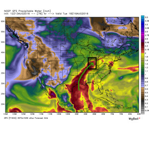
Precipitable water will once again surge to 2.5″+ and promote intense rainfall rates over a more widespread portion of the region Sunday night through Tuesday.

1Unlike the localized banding features of the rain today, the rain shield should be much more widespread Monday into Tuesday.  Factor in the hefty rain totals today into Sunday, combined with additional heavy rain Monday and Tuesday, and it wouldn’t surprise us to see a few double digit rainfall reports by the time all is said and done Wednesday night/ Thursday.  Widespread 4″+ totals will be common across central IN by the time all is said and done.

We flip the script next weekend and turn much drier and unseasonably cool.  It’ll feel like an early taste of fall next weekend (perhaps even some upper 40s for a few folks across central portions of the state)?!

Heed flood warnings that come over the next few days.  Rainfall rates will be downright tropical in nature and result in fast water rise.

Permanent link to this article: https://indywx.com/2016/08/13/saturday-evening-update/

VIDEO: More On Our Multiple Day Heavy Rain Event…

You must be logged in to view this content. Click Here to become a member of IndyWX.com for full access.  Already a member of IndyWx.com All-Access?  Log-in here.

Permanent link to this article: https://indywx.com/2016/08/13/video-more-on-our-multiple-day-heavy-rain-event/

Multi-Day Heavy Rain Event…

Central IN is still in play for a multi-day heavy rain event that begins this weekend and continues into the middle of next week.

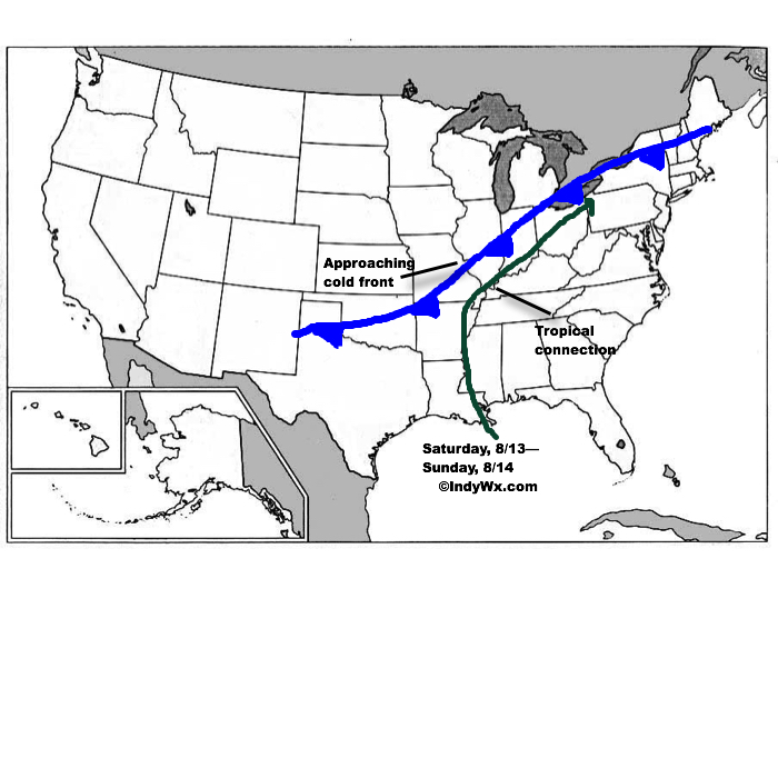
The setup is still one that features a wavy cold front that will halt to a crawl (eventually becoming stationary) over central and southern IN over the weekend.  Additionally, tropical moisture will continue to slowly push north, before curling northeast (following the frontal boundary) into the Ohio Valley.  The image below from Monday displays the setup nicely.

Wknd8:13Despite lackluster model output from our American suite (latest NAM and SREF data, for instance, paints rainfall totals under 1″ across most central IN neighborhoods), the European remains consistent on the evolution of things from this weekend into the middle of next week.  We’ll lean more towards it’s solution at this juncture.  Simply put, when you have a stalled frontal boundary entraining tropical moisture, expect problems.  Precipitable water values will approach and even exceed 2″ at times this weekend.  Dew points will remain in the upper 60s to lower 70s along and south of the boundary.  Where the boundary stalls will be key in determining the heaviest rain totals and resulting flood problems that will ensue.  For now, here’s the best idea we have in regards to local 4″+ totals between this weekend and next Wednesday.
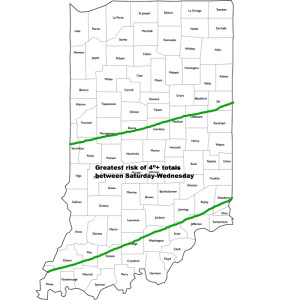
HVYRainTotalsIt should also be pointed out that we’re not looking at all day rains Saturday through Wednesday, but instead “waves” of moisture throughout the period.  Areas of locally heavy rain will be with us, but we’ll also see dry periods in between.  Thankfully, as we move into the latter portions of next week, drier times should return.
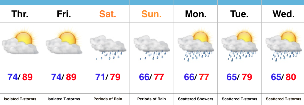
We’ll be here through the weekend to keep you updated on things, as well as on social media.  Stay tuned.

Permanent link to this article: https://indywx.com/2016/08/12/multi-day-heavy-rain-event/

A Wet Weekend In Store…

Screen Shot 2016-08-11 at 7.22.58 AMHighlights:

  • Tropical feel
  • Heavy weekend rains
  • Unsettled early next week

Zoning In On Heaviest Rains…It’s about as humid as it can get across central IN.  “Air you can wear” is the appropriate way to describe this humidity and overall sultry feel.  As we’d expect with this tropical air mass, isolated to widely scattered strong storms could pop at any point and result in locally heavy rain.  We’ll “rinse and repeat” today’s forecast to wrap up the work week.

Attention then shifts to a widespread soaking rain event this weekend as two main players “team up” to produce a localized flood threat.  A cold front will sag into central IN while remnant tropical moisture slowly moves north and eventually curls northeast.  Precisely where the front stalls in response to the tropical low moving north will be where heaviest (4″+) rains set up.  Thinking this morning places the greatest risk somewhere between Indianapolis and Louisville, but we caution that we still want to see a couple more model runs before settling on a given area.  Unsettled weather will likely continue into early next week as tropical moisture slowly exits stage right.

Longer term, indications point towards an overall cooler, wetter, back half of August. Times- they are ‘a changing!

Upcoming 7-Day Precipitation Forecast:

  • Snowfall: 0.00″
  • Rainfall: 2.00″-4.00″

Permanent link to this article: https://indywx.com/2016/08/11/a-wet-weekend-in-store/

VIDEO: Flooding Prospects On The Rise, But Fine Tuning Required…

You must be logged in to view this content. Click Here to become a member of IndyWX.com for full access.  Already a member of IndyWx.com All-Access?  Log-in here.

Permanent link to this article: https://indywx.com/2016/08/10/flooding-prospects-on-the-rise-but-fine-tuning-required/

VIDEO: Weekend Heavy Rain Threat…

You must be logged in to view this content. Click Here to become a member of IndyWX.com for full access.  Already a member of IndyWx.com All-Access?  Log-in here.

Permanent link to this article: https://indywx.com/2016/08/09/video-weekend-heavy-rain-threat/

Monitoring Prospects For Heavy Weekend Rain…

A combination of ingredients are coming together to offer up the potential of heavy rain for portions of the region this weekend.

An approaching cold front will drop slowly southeast out of the Plains while a tropical low moves inland from the central Gulf Coast.

Wknd8:13The precise placement of the front will serve as the focal point for heavy weekend rains.  As we’d expect from this distance, modeling disagrees on the all-important specifics.  Using a model blend, central Indiana is on the table for heavy late week-weekend rain as of now.  Precipitable water values (PWATs) will be above 2″ and suggest the threat of torrential downpours, including localized flash flooding across the Ohio Valley.  Eventually, the cold front will sweep the tropical-rich moisture away from the region and cooler, much less humid air will press in by this time next week.
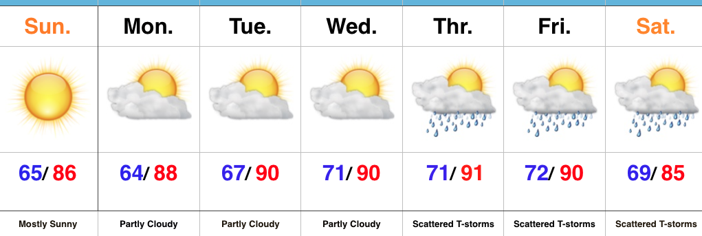
We still have time to watch the evolution of things play out as we progress through mid week. Stay tuned as we “sure-up” the details and hone in on the area where heavy rain is likely.

Permanent link to this article: https://indywx.com/2016/08/08/monitoring-prospects-for-heavy-weekend-rain/

Dry And Turning Hot; Watching Late Week…

Screen Shot 2016-08-07 at 10.47.30 AMHighlights:

  • Sun-filled days
  • Heat cranks up
  • Late week questions

Turning Up The Heat…After a refreshing weekend, the heat returns later this week.  Look for highs in the lower 90s with an oppressive feel to the air, as humidity builds.  “Air you can wear” will be an appropriate forecast title come mid week.  The forecast is easy through the midweek stretch with sunshine as the rule.

Things become more unclear as we approach the back half of the week and the weekend.  We note the GFS is rather progressive in swinging a cold front through here with scattered showers and thunderstorms, followed by a significantly cooler/ drier air mass a week from today.  On the  other hand, the European solution is drastically different as it slows the front to a “crawl” coming through the Ohio Valley and also entrains GOM (Gulf of Mexico) moisture from the serious rain/ flood maker later this week across the Gulf states.  It’s a significantly wetter look, locally, and a situation we’ll continue to keep a close eye on in the coming day, or two.

Upcoming 7-Day Precipitation Forecast:

  • Snowfall: 0.00″
  • Rainfall: 0.50″-1.00″

Permanent link to this article: https://indywx.com/2016/08/07/dry-and-turning-hot-watching-late-week/

IndyWx.com