Major Storm Brewing This Weekend, But Details Are Murky…

During the late summer and early autumn months we were trying to look at the big picture and potential drivers in the overall weather pattern for the upcoming winter and openly admitted the challenges that were ahead.  Here we are now into the second half of December and a much colder and snowier-than-average month is a virtual lock at this point.  Furthermore, consider this has all taken place without the presence of a favorable NAO or PNA.  Sometimes you have to look for other drivers in a pattern- in this case, the EPO, as well as a growing early fall snow pack across the border to our north.  Additionally, we made mention of the likelihood of a southeast US ridge periodically making itself known through the winter of ’13-’14.  You can read all of our thoughts posted earlier this fall here, or by clicking the Thoughts On Winter ’13-’14 page above.

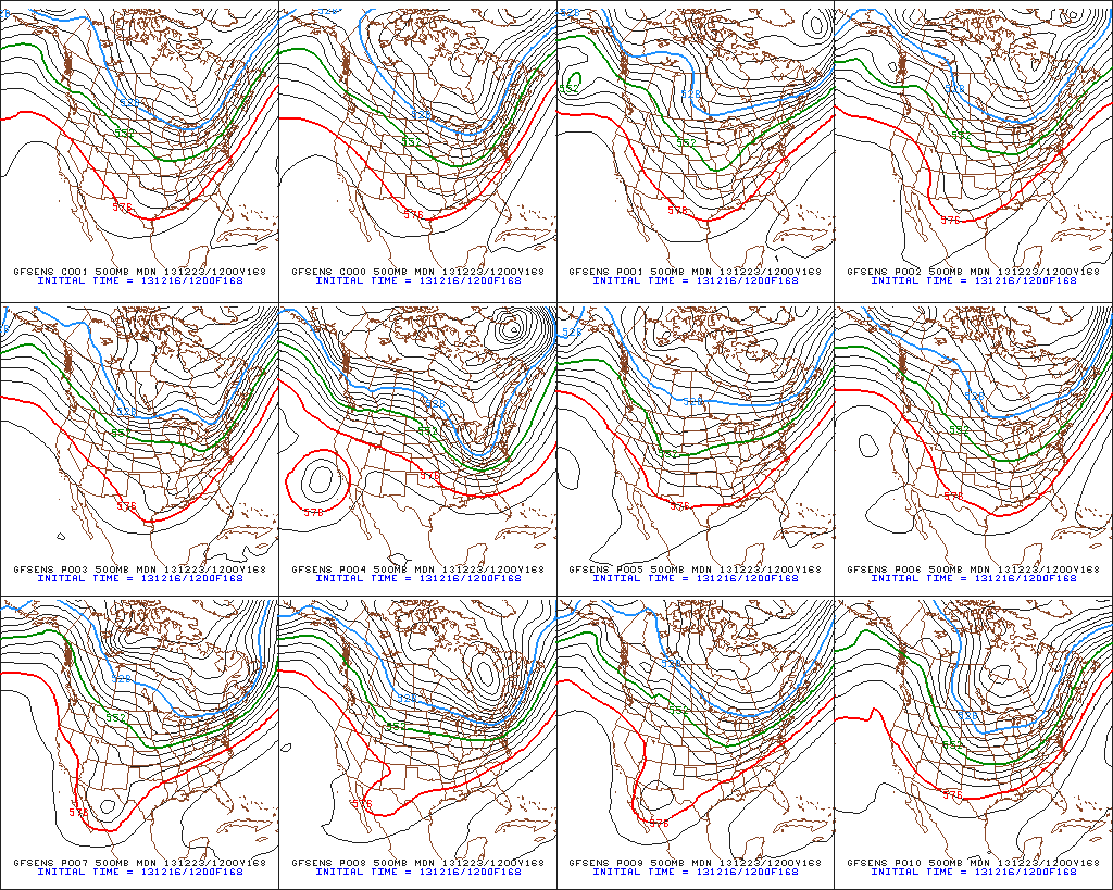
As we look ahead towards the upcoming wintry challenge, we’re confident of the overall pattern, but the sensible weather that’ll ensue is still up for great debate.  “Gut” tells me central Indiana will be looking at a rain to freezing rain scenario, but this is far from set in stone, and sometimes forecasters who go simply off their instinct can get burned.  The pattern is one that (once again) will feature a pressing arctic front against resistance from the southeast US ridge.  With this type of scenario, I would advise against looking at each and every individual operational model run, but instead invest time studying the ensembles- an average of several multiple model runs as opposed to just one operational model run.   I can guarantee a variety of wild solutions ahead in the days to come, based off the operational runs. (Heck, just the past 24 hours have been reason enough to have the dramamine on hand :-)).  That said, let’s take a look at the latest GFS and European ensembles, two models that we rely heavily on in the mid range weather pattern.

First, the GFS, valid Saturday through Monday.

f120f144f168

Now, here’s a look at the latest European ensembles (left), again valid Saturday-Monday.

Geopotential32at32500hPa_North32America_120Geopotential32at32500hPa_North32America_144 Geopotential32at32500hPa_North32America_168

So what do all of these cool maps tell us?  Simply put, that “wintry mischief” is brewing for the weekend.  That much we know, but the details have to be ironed out.  It’s likely heavy snow and a significant ice storm looms for some of the Mid West and Ohio Valley for the upcoming weekend.  Is that Indianapolis or Chicago?  Perhaps in between?  It’s too early to know.  Additionally, in the “warmer” sector, heavy rains are likely to combine with an impressive early season snow pack for some to lead to flooding concerns.

A couple of additional items to note. Many times at this stage in the game (still 5+ days out) with this type of pattern, forecast models really struggle with handling low level cold air.  Cold air is very dense and, in this type of set up, can easily drain much further east and south than forecast at this juncture.  Additionally, sometimes the modeling can put too much “umph” into the associated surface wave that moves along the arctic front resulting in a further north track than what may actually occur when the event draws closer.  Just something to keep an eye on as we draw closer…

Needless to say, it’ll be particularly important to keep a close eye on the developing weekend forecast as we move forward.  It’s likely folks in the Ohio Valley region have to deal with significant precipitation amounts in the Saturday-Monday time period, including rain, freezing rain, and snow.

Heavy Rain And Severe Outbreak Sunday

We continue to analyze the latest data concerning our pending severe weather episode ahead Sunday.  Today’s information continues to point towards the threat of not only a damaging straight line wind event, but the potential of multiple tornadoes across the central Ohio Valley.  The tornado threat would most likely occur with any individual super cells that develop Sunday afternoon.  The damaging straight line wind event would then be associated with what’s likely to be a squall line associated with the cold frontal passage Sunday night.  Needless to say, Sunday will be busy weather day across not only the Hoosier state, but for many folks across the Mississippi River Valley into the Ohio Valley.  Additionally, widespread heavy rain is also a good bet.  Let’s look at some data:

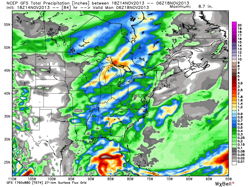
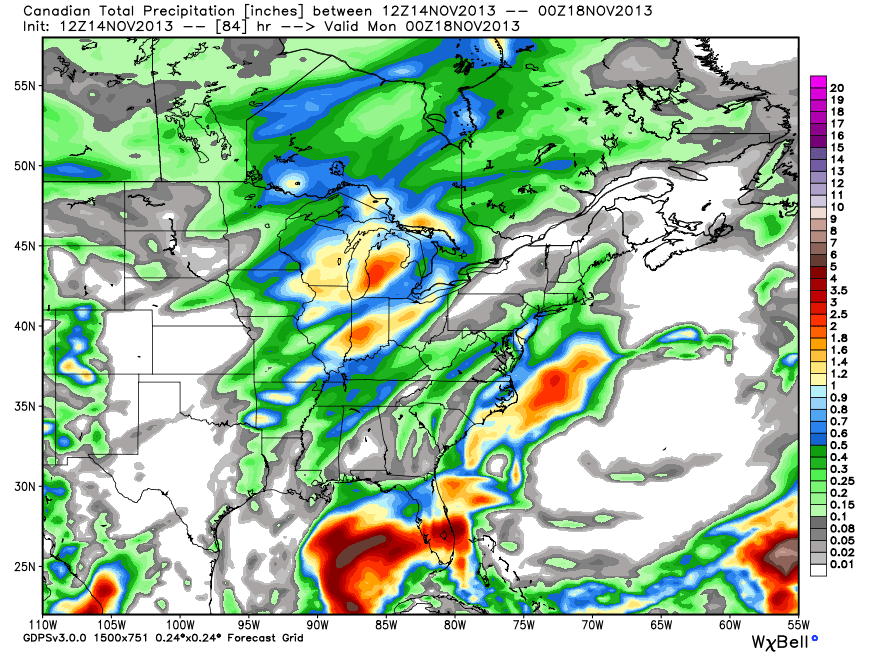
First, let’s look at some rainfall numbers.  The ECMWF (European forecast model) and GEM (Canadian forecast model) are the most aggressive with rainfall totals approaching the 2″ mark for many areas of central Indiana between Sunday and Monday.  The GFS isn’t as bullish, forecast a little more than half an inch on it’s latest run.  Officially we’ll go with a blend of all three models and suggest widespread 1″ type rains across central Indiana during the Sunday-Monday period.

ecmwf_tprecip_indy_21cmc_total_precip_east_15gfs_total_precip_east_15

Before we go further, we also want to highlight that winds will be strong and gusty Sunday even well away from any thunderstorms.  Winds will likely gust to 40-50 MPH simply by the tightening pressure gradient as surface low pressure begins to “bomb out” (rapidly intensify) on it’s journey into the Great Lakes region.

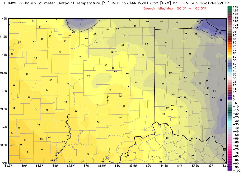
The dynamics are somewhat scary with this event and, as stated above, suggest not only an enhanced straight line damaging wind event, but also the potential of multiple tornadoes associated with any super cells that get going Sunday afternoon, well ahead of the squall line.  Despite a cold, dry air mass in place currently, the aforementioned strong southerly winds will help transport dew points into the lower to middle 60s come Sunday afternoon.  This will only help add fuel to the fire for storm development.

ecmwf_dew2m_indy_14

Let’s take a look at the official Severe Weather Outlook for Sunday, courtesy of the Storm Prediction Center.  Some highlights from their most recent discussion:

SOME UNCERTAINTY LINGERS...BUT TRENDS IN THE MEDIUM RANGE FORECAST
   GUIDANCE ARE INCREASINGLY SUGGESTIVE OF THE DEVELOPMENT OF AN
   ENVIRONMENT SUPPORTIVE OF AN OUTBREAK OF SEVERE THUNDERSTORMS ACROSS
   PARTS OF THE MIDDLE MISSISSIPPI VALLEY EASTWARD THROUGH MUCH OF THE
   OHIO VALLEY ON SUNDAY.
A 90+ KT 500 MB JET STREAK NOSING THROUGH THE OHIO VALLEY...COUPLED
   WITH STRENGTHENING SOUTHERLY WARM SECTOR 850 MB FLOW...PERHAPS IN
   EXCESS OF 70 KTS ACROSS PARTS OF THE OHIO VALLEY INTO THE LOWER
   GREAT LAKES...WILL CONTRIBUTE TO VERY STRONG DEEP LAYER WIND FIELDS
   AND SHEAR.  IT ALSO APPEARS INCREASINGLY PROBABLE THAT THIS WILL
   COINCIDE WITH AN INFLUX OF SEASONABLY HIGH MOISTURE CONTENT AT LEAST
   AS FAR NORTH AND EAST AS THE LOWER OHIO VALLEY...CONTRIBUTING TO
   SUFFICIENT CAPE FOR VIGOROUS STORM DEVELOPMENT.  SUPERCELLS WITH A
   RISK FOR TORNADOES WILL BE POSSIBLE...PARTICULARLY IN EARLY STAGES
   OF CONVECTIVE DEVELOPMENT...PERHAPS AS EARLY AS MID DAY ACROSS PARTS
   OF THE MIDDLE MISSISSIPPI INTO LOWER OHIO VALLEY VALLEY
EVENTUALLY...THOUGH...ACTIVITY PROBABLY WILL EVOLVE INTO A SQUALL
   LINE WITH DAMAGING STRAIGHT-LINE WINDS BECOMING THE MOST PROMINENT
   SEVERE THREAT.

day48prob

Wednesday Forecast: Rainy Midweek

Updated 11.05.13 @ 3:43p

Zionsville, IN Clouds are hanging tough this afternoon and rain isn’t too far off. Rain will increase Wednesday, becoming widespread the second half of the day. MUCH colder air will then blow into the region Wednesday night and Thursday.

Status-weather-showers-scattered-iconWednesday: Rain likely (0.55); 34/ 58

Wednesday will feature another gloomy day with rain overspreading the region from west to east. Scattered showers will be present through the morning hours before giving way to steadier, heavier rainfall during the second half of the day. Latest data suggests the cold front is speeding up from the last forecast update and this should result in a FROPA (frontal passage) Wednesday night. It’ll also be a windy day, with southwest gusts of 25-30 MPH during the day, shifting to the northwest Wednesday night.  Colder air will pour into the state behind the front, setting up a chilly, blustery Wednesday night and Thursday.

Status-weather-clouds-iconThursday: Partly cloudy; 33/ 47

A blustery northwest wind will blow Thursday and combine with a partly cloudy sky and an unseasonable chill to create a rather cold day. Winds will gust upwards of 20 MPH from time to time.


Status-weather-clouds-iconFriday: Partly cloudy; 30/ 51

A hard freeze will greet us as we prepare to wrap up the work week. Widespread lows around 30 will be commonplace before partly cloudy skies help temperatures rise into the lower 50s Friday afternoon.


Status-weather-clouds-iconSaturday and Sunday: Partly cloudy; 40 Sat, 36 Sunday/ lower to middle 50s

High pressure will remain in control of our weather Saturday.  While a weak storm system will pass through the upper Great Lakes region, it’ll remain well north of our area. Southwest breezes could gust up to 20 MPH Saturday afternoon. Otherwise, we’re looking at some mid and high level cloudiness and middle 50s Saturday afternoon and lower 50s Sunday.

Status-weather-clouds-iconMonday: Partly cloudy; 38/ 50

Dry and slightly cooler than normal conditions will greet us as we kick off the new work week.


Status-weather-showers-day-iconTuesday: Scattered shower (0.10); 36/ 50

The early look at next week shows more questions than answers.  For now we forecast scattered showers as our next weather system approaches from the west, but we caution this is a low-confidence forecast.  Be sure to stay tuned as we update things moving forward.


Wet Pattern Continues

While the midday model data continues to flip flop on the temperature outcome next week, one thing seems rather likely and that’s the idea we remain in a pattern that will produce significant rainfall over the next 10 days.

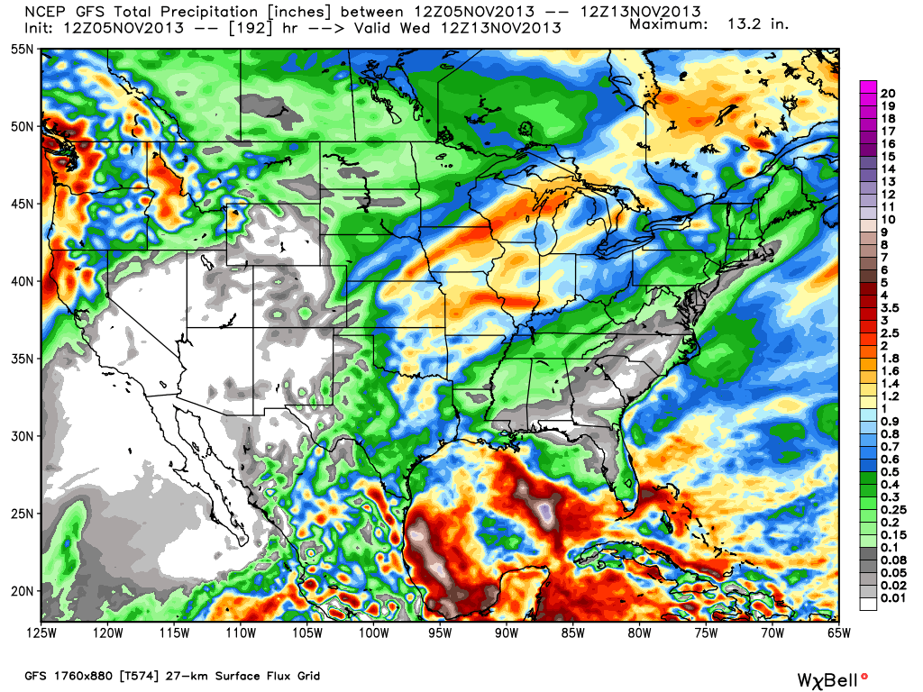
Let’s take a look at the ECMWF, GFS, and GEM (Canadian) for precipitation amounts over the next 7-10 days.

gfs_tprecip_conus2_65cmc_precip_by10_conus_1ecmwf_precip_10_conus_41

Model data paints a wet picture of widespread 1.5″-2″+ type rainfall totals over the upcoming 7-10 day period.

Monday Forecast: Tracking Another Storm

Updated 11.03.13 @ 3:30p

Zionsville, IN It’s been a beautiful fall weekend across central Indiana. Aside from a couple of quick-moving showers Saturday evening, the weather couldn’t have been more perfect!  While the work week will start off on a pleasant note, we’re tracking another storm and significant blast of chill later this week.

Status-weather-clouds-iconMonday: Partly to mostly cloudy; 38/ 58

The day should dawn with bright sunshine, however, we note the latest high resolution short-term model data suggesting mid and high level cloudiness will be on the increase through the afternoon hours.  It’ll be a dry day with seasonable temperatures.  Enjoy!

Status-weather-showers-day-iconTuesday: Mostly cloudy; nighttime light showers (0.10″); 44/ 61

We’ll be in between high pressure to our east and our next approaching storm system to our west. As a result, a return southerly flow of air will help begin to transport milder air northward, along with increasing moisture Tuesday evening. The daytime hours should remain rain-free, but we’ll introduce a couple of light showers into our forecast Tuesday night.

Status-weather-storm-night-iconWednesday: Showers and thunderstorms, especially at night (0.70″); 49/ 60

A significant cold front will approach the region Wednesday. Showers will be likely through the day, but we still believe the heavier rains and embedded thunder will hold off until Wednesday night (especially after dark).  While we’re still monitoring any threat of severe weather, the bigger threat at this time appears to be another round of heavy rain falling atop a waterlogged central Indiana.  Stay tuned as we continue to analyze the latest data and update things accordingly.

Status-weather-showers-day-iconThursday: AM showers and thunderstorms (0.40″);  38/ 55 (falling)

The cold front will blow through the region Thursday morning.  Showers and thunderstorms will end west to east during the morning followed by a sharp temperature decline through the day, coupled with strong northwesterly winds gusting upwards of 30 MPH.

Status-weather-clouds-iconFriday: Partly cloudy; 29/ 48

A much colder air mass will settle into central Indiana Thursday evening and result in a hard freeze Friday morning. After waking up to lows in the upper 20s, highs will reach the upper 40s with partly cloudy skies.


Status-weather-clouds-iconSaturday: Partly cloudy and breezy; 40/ 55

Our fast-moving weather pattern will remain next weekend.  We’re tracking another storm system that will blow through the Great Lakes region Saturday. Current thinking places the track of this low too far north to impact the region from a precipitation standpoint, but we’ll certainly note a strengthening southwesterly wind Saturday followed by another shot of cold air Saturday night/ Sunday.  Highs next Sunday will likely remain in the 40s…