Monday Night Severe Weather Update.

Good evening and welcome in to IndyWx.com!

We continue to closely monitor radar and satellite trends tonight and keep a close eye on severe developments to our west.  As the video discusses, the clouds and rain from earlier today have helped in a big way from at least limiting what today “could have been” from a severe perspective.

That’s not saying we’re signaling the all-clear by any stretch of the imagination, it’s just saying that the clouds and rain from earlier have helped to keep us from really destabilizing the local atmosphere and the clearing we’re seeing now may be too little too late in regards to widespread severe weather here.

All of that said, keep a close eye on local radar tonight and remain weather aware.  The dynamics at play could result in a thunderstorm turning severe rather rapidly tonight and we’ll continue to closely monitor.

Strong to potentially severe thunderstorms will impact central Indiana during the overnight period:

hrrr_ref_indy_9

The video below has more details:

Nice Weekend Before A Prolonged Rainy/ Stormy Stretch…

A mostly dry and warm weekend is underway.  The Friday afternoon sunshine we enjoyed is a preview of what the majority of the weekend will provide.  We note the threat of a scattered shower or storm across northern portions of the state during the predawn hours Saturday and across central portions of the state (including Indianapolis) during the predawn hours Sunday. That said, in both cases, most will remain rain-free.

The big event is still slated for a late Sunday night arrival.  Low pressure will sit and spin across the Plains states Saturday into Sunday.  While we stay mostly dry, a major severe weather outbreak will likely unfold across this area during the day Saturday and again Sunday.

Better chances of rain and thunderstorms will arrive across central Indiana late Sunday night.  Some of these storms may be strong, but we think it’s more in the Monday and Tuesday time frame where we really need to be on our toes in regards to severe potential.  At this juncture, it appears as if all modes of severe weather will be in play across the region, including tornadoes, hail, and damaging straight line winds.  An enhanced risk of severe weather will lie across southern portions of the state.

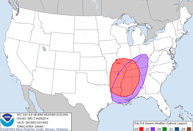
The Days 4 and 5 severe weather outlook from the fine folks at the Storm Prediction Center (SPC) will likely be expanded north as we move forward.day48prob
Forecast radar from some of our high resolution model data suggests thunderstorms begin to rumble into the state as early as Sunday night.
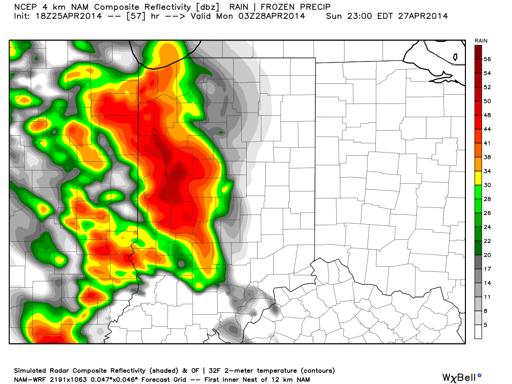
hires_ref_indy_58

Eventually, this big spring storm will begin to weaken and turn into a large closed off upper level low pressure system. This promises a MUCH cooler stretch here mid to late next week along with continued unsettled conditions, with periods of showers and blustery northwest winds.  In fact, IND very well record measurable precipitation every day Sunday through next Saturday…
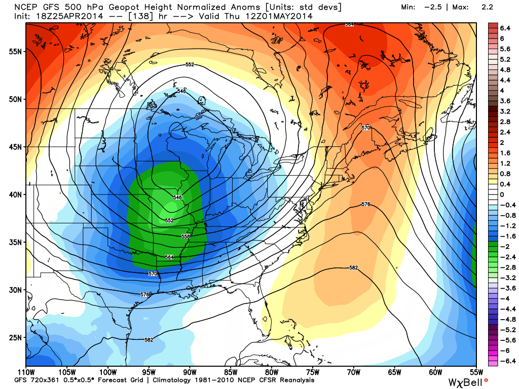
gfs_z500_sig_east_24

After a warm weekend and early week, note the colder air moving in to wrap up April and open May. Temperatures are moving in the wrong direction.  Highs by the mid to latter part of next week will only make it into the lower 50s some days.  The first week of May looks much cooler than average.
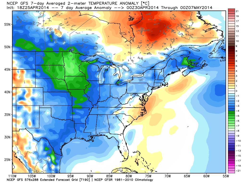
gfs_t2x_anom7_east_18


Lots Of Weather To Talk About…

There are growing concerns about quite the rainy and cold close to April and open to May. We’ll discuss that in a bit. The month so far has been cold…

You must be logged in to view this content. Click Here to become a member of IndyWX.com for full access.  Already a member of IndyWx.com All-Access?  Log-in here.

Will Thursday Be The Day?

Thr.

Fri.

Sat.

Sun.

Mon.

Tue.

Wed.

 Status-weather-showers-day-icon

 Status-weather-clouds-icon

 Status-weather-showers-day-icon

 Status-weather-showers-day-icon

 Status-weather-storm-night-icon

 Status-weather-clouds-icon

 Status-weather-clouds-icon

44/ 70

45/ 62

44/ 68

58/ 72

37/ 58

28/ 48

30/ 50

Light

– – –

Light

Light

Moderate

– – –

– – –

Custom IndyWx.com Forecast Updated 04.09.14 @ 6:26p

Making The Push For 70. . .Thursday should be our first 70 degree day of 2014.  While clouds will be on the increase through the afternoon, we should enjoy enough of a southwest breeze and sunshine early in the day to allow temperatures to reach the 70 degree mark for afternoon highs.

We do note a frontal boundary that will move through the region Thursday evening, and this will be capable of producing a round of quick-hitting showers and a possible rumble of thunder.  Rainfall amounts will be light.  We think drier air will allow for increasing amounts of sunshine as we go through your Friday.

Warm, Mostly Pleasant Weekend. . .Most of Saturday will be rain free, but we’ll introduce the threat of a scattered shower Saturday afternoon as moisture begins to return.  Similar to that of Thursday, we’ll make yet another push at the 70 degree mark before clouds and rain chances begin to put a lid on the temperature climb.

While Sunday will feature better rain chances, it won’t be a wash out by any stretch of the imagination.  We certainly don’t recommend canceling any outdoor activities this weekend; just keep the umbrella handy should you have to dodge a thundershower.

Better Rain; Storm Chances. . .Rain and thunderstorm chances will begin to ramp up as we go into Sunday night into Monday.  Modeling continues to struggle in terms of the precise details of our early week events, but we’re confident on a round of rain and potential gusty thunderstorms before a cooler surge of air invades Monday night and Tuesday.  Stay tuned as we’ll have a good deal of fine tuning to do for the Sunday night-Monday night forecast.

Upcoming 7-Day Precipitation Forecast:

  • 7-Day Rainfall Forecast: 1″ – 1.5″
  • 7-Day Snowfall Forecast: 0.00″

twicFor weather updates and more “behind the scenes” data on the go, be sure to Follow Us on Twitter @indywx or become a Friend of IndyWx.com on Facebook!

images