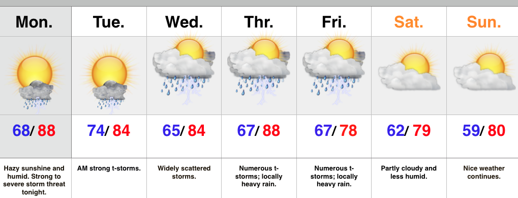
Category: Heavy Rain

Busy Times In The Forecast Office…

Today is the beginning of several active days around these parts. Over the course of the next few days severe weather and heavy rainfall will keep us on our toes…

You must be logged in to view this content. Click Here to become a member of IndyWX.com for full access.  Already a member of IndyWx.com All-Access?  Log-in here.

Permanent link to this article: https://indywx.com/busy-times-in-the-forecast-office/

Today Is The Pick Of The Week; Wet And Stormy Pattern Looms…

Screen Shot 2015-06-13 at 9.02.37 AMHighlights:

  • Best weather of the week is today
  • Strong to severe storm potential Sunday and Monday
  • Widespread heavy rain threat mid week
  • Unsettled pattern continues

We’re opening the weekend with dry skies across central IN, along with a very tropical feel.  The combination of a nearby weak boundary and the humid air mass will help fuel isolated to widely scattered storms this afternoon.  That said, overall coverage of storms will be reduced from what we saw Friday.  Most of the day will feature dry conditions.

We’ll begin to increase storm chances as we rumble into the second half of the weekend and on into the new work week.  Some of these may be strong to severe Sunday-Monday, including strong damaging winds and large hail.

Attention will then shift to mid week and the potential of an excessive rainfall event.  Modeling is leaning towards tracking a tropical disturbance north out of the western GOM (Gulf of Mexico) before shifting northeast around the periphery of a southeastern ridge.  Very heavy rainfall would result if this idea pans out.  Stay tuned.

Upcoming 7-Day Rainfall Potential: 2″-4″ (locally heavier totals) 

Permanent link to this article: https://indywx.com/today-is-the-pick-of-the-week-wet-and-stormy-pattern-looms/

Strong To Severe Storm Potential; Active Pattern…

The Storm Prediction Center highlights the region for a risk of severe weather both today and Sunday.  Day 1 Outlook   Day 3 Outlook    As for timing, we expect…

You must be logged in to view this content. Click Here to become a member of IndyWX.com for full access.  Already a member of IndyWx.com All-Access?  Log-in here.

Permanent link to this article: https://indywx.com/strong-to-severe-storm-potential-active-pattern/

Storms Tonight; Heat Builds This Week…

Screen Shot 2015-06-08 at 5.57.06 PMHighlights:

  • Stormy tonight for some
  • Heat builds this week
  • Better storm chances return for the weekend

A cold front remains off to our northwest as we type this and big storms are firing across northern portions of the state.  We’ll keep a close eye on those as they move southeast tonight and begin to pick up more forward momentum in the coming hours.  They’ve had a history of producing damaging hail.  Remain weather-aware this evening.

Thankfully we’ll begin to inject a drier air mass (briefly) into the region Tuesday.  A nice day is coming with lower humidity.  Most of the second half of the work week will also remain dry, but as humidity increases we have to mention the threat of an isolated to widely scattered storm.  The big story will be the heat as highs push into the 90 degree territory.  Prepare to sweat!

Better chances of showers and thunderstorms will push back into the region over the upcoming weekend.  We’re not forecast a complete washout either Saturday or Sunday, but with a very humid air mass in place, any shower or storm that develops will have the capability of producing torrential downpours.

Upcoming 7-Day Rainfall Potential: 1.5″ – 2.5″

Permanent link to this article: https://indywx.com/storms-tonight-heat-builds-this-week/

Very Active Night Ahead…

An active and noisy night is on tap, friends, as multiple storm clusters move through central Indiana.  Initially, the concern is hoisted for severe weather, including damaging winds and hail. As the night progresses, the growing concern will be flash flooding as storms train over the same area, potentially leading to 3″+ rains in localized areas.

We’re currently eyeing convection firing to our northwest and these storms will push southeast this evening.  They will move into a very warm, humid, and unstable environment and will likely strengthen as they ride into north-central IN later this evening.  Here’s a snap shot of the radar valid at 8p:

8pNote as we progress into the overnight, additional storms are likely and flooding concerns are on the rise due to this. Radar valid at 3a:

3aRainfall totals of 1″-2″ will be common tonight across central IN, but some localized reports of 3″-4″ can’t be ruled out where storms train.  Here’s a look at potential rainfall numbers through 5a:

hrrr_t_precip_indy_16We note PWATs (precipitable water values) pushing close to 2″ overnight and this increases our confidence on the heavy rainfall potential, as well:

hires_pwat_indy_20Stay weather-aware tonight, friends!

Permanent link to this article: https://indywx.com/very-active-night-ahead/