Updated 09.22.21 @ 7:34a
You must be logged in to view this content. Click Here to become a member of IndyWX.com for full access. Already a member of IndyWx.com All-Access? Log-in here.

Sep 22
Updated 09.22.21 @ 7:34a
You must be logged in to view this content. Click Here to become a member of IndyWX.com for full access. Already a member of IndyWx.com All-Access? Log-in here.
Permanent link to this article: https://indywx.com/video-chilly-with-a-wind-whipped-rain-sunshine-returns-friday/
Sep 21
Updated 09.21.21 @ 7:30a
You must be logged in to view this content. Click Here to become a member of IndyWX.com for full access. Already a member of IndyWx.com All-Access? Log-in here.
Permanent link to this article: https://indywx.com/video-more-of-a-november-like-feel-turning-wet-raw-and-windy-for-midweek/
Sep 20
Updated 09.20.21 @11:18p First, let me apologize for the later than originally planned update. (It’s been a Monday :-)). Having had a chance to look over the various updated computer…
You must be logged in to view this content. Click Here to become a member of IndyWX.com for full access. Already a member of IndyWx.com All-Access? Log-in here.
Permanent link to this article: https://indywx.com/video-transition-to-a-cooler-pattern-includes-big-midweek-questions/
Sep 19
Updated 09.19.21 @ 9:04p


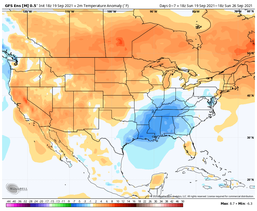
Forecast Period: 09.19.21 through 09.26.21
A much more active weather pattern will take control of the region during the above mentioned forecast period. An area of low pressure will track north into the Ohio Valley during the overnight and Monday morning which will help lead to an expanding area of rain and embedded thunder to kick off the work week. Rain is expected to be most widespread across the southern half of the state early in the day before making progress north. As this is taking place, a cold front will take aim on the region from the west, and should push through the Hoosier state Tuesday with a line of showers and thunderstorms. While there could be a couple of stronger storms widespread severe weather isn’t expected. Perhaps what will be a bigger “headache” will have to do with the evolution of things as the front is moving east across Indiana. A wave of low pressure is expected to develop to our south Tuesday before lifting north…
As of Sunday evening, two of our more trusted forecast models (GFS and European) differ with respect to exactly where the developing surface low will track (GFS is more progressive while the European is slower). Regardless, MUCH cooler air will pour into the region through the middle of the week. Should the slower European solution (our lean at the moment) come to fruition, then we’re looking at a midweek rain out, combined with October-like daytime temperatures. Chili weather, anyone?! Stay tuned for future updates as we fine tune things for midweek. High pressure will return in time for the weekend, allowing sunshine and pleasant fall temperatures to claim headlines.
Permanent link to this article: https://indywx.com/weekly-agwx-and-harvest21-outlook-3/
Sep 18
Updated: 09.18.21 @ 1a
You must be logged in to view this content. Click Here to become a member of IndyWX.com for full access. Already a member of IndyWx.com All-Access? Log-in here.
Permanent link to this article: https://indywx.com/those-special-college-football-saturdays-return-rolling-into-a-more-fall-like-weather-pattern/