Category: Harvest19

VIDEO: Rain Develops By Evening; Potential Of Pre-Halloween Snow?

You must be logged in to view this content. Click Here to become a member of IndyWX.com for full access.  Already a member of IndyWx.com All-Access?  Log-in here.

Permanent link to this article: https://indywx.com/2019/10/15/video-rain-develops-by-evening-potential-of-pre-halloween-snow/

VIDEO: Frosty Midweek; Colder And Active Stretch Of Weather For Late October?

You must be logged in to view this content. Click Here to become a member of IndyWX.com for full access.  Already a member of IndyWx.com All-Access?  Log-in here.

Permanent link to this article: https://indywx.com/2019/10/14/video-frosty-midweek-colder-and-active-stretch-of-weather-for-late-october/

Harvest ’19: Tis The Season For Changeable Weather Patterns…

*Starting November 1st, our weekly agriculture and harvest updates will transition to weekly winter storm outlooks. We’ll maintain a lot of the feedback y’all have provided with the new weekly winter products. Come next growing season, the weekly agriculture and severe weather updates will return.

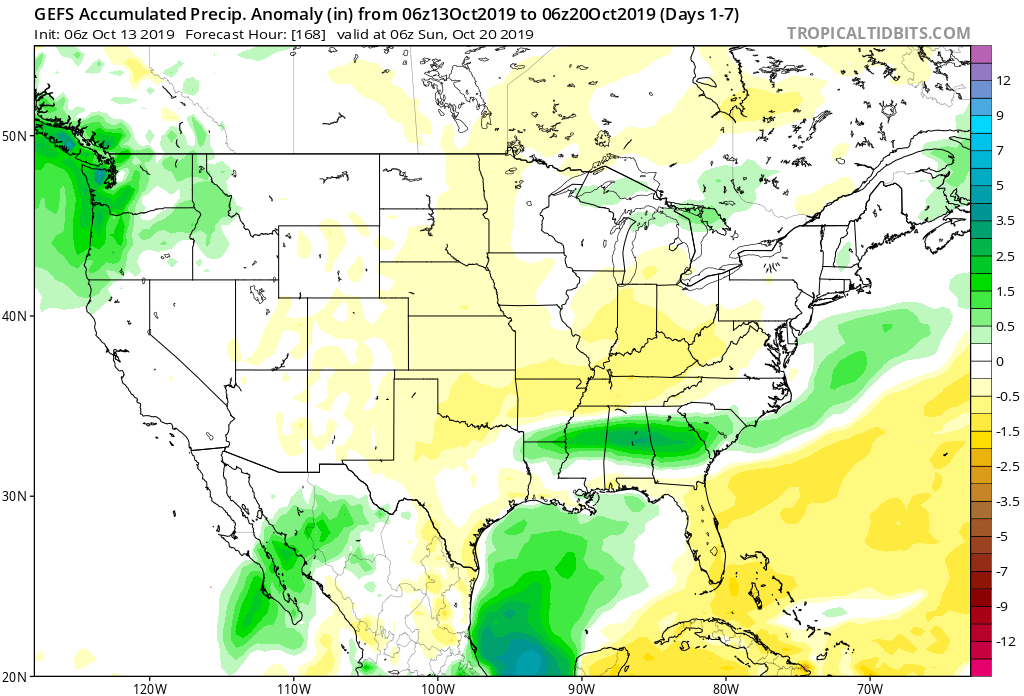
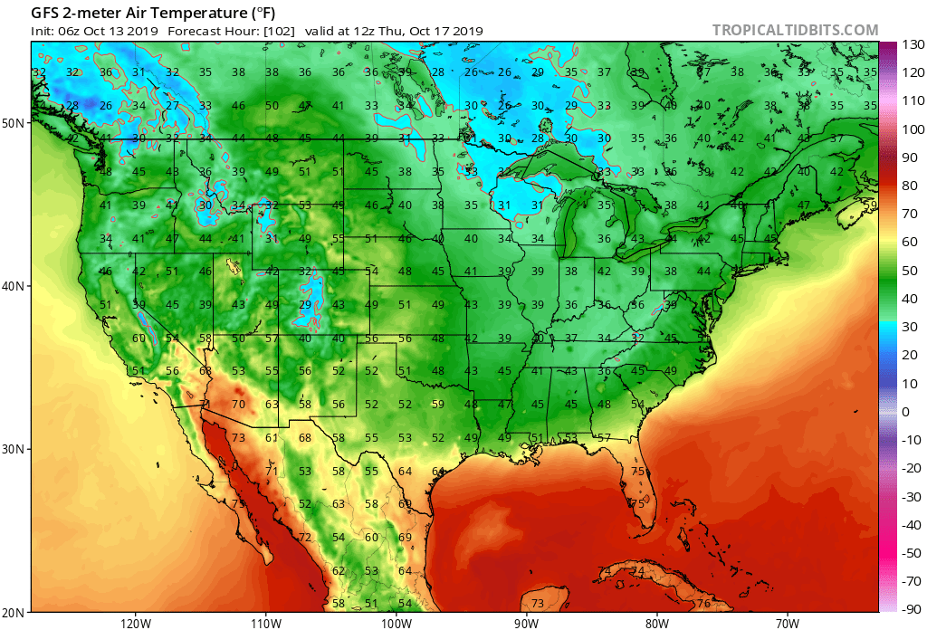
Forecast Period: 10.13.19 through 10.20.19

7-Day Precipitation: Below average precipitation is expected through the period.

7-Day Temperatures: Below average temperatures are expected overall throughout the period.

Severe Weather: Severe weather isn’t anticipated through the period.

Frost/ Freeze: Many across the central and northern Ohio Valley have now recorded their first frost or freeze of the season. Additional frosty mornings are ahead during the upcoming forecast period with Thursday morning looking like the coldest as of now. The first frost and/ or freeze of the season will continue to advance southeast with the southern Appalachians likely putting an end to their growing season by Thursday morning.

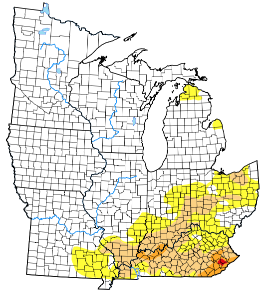
Drought Monitor: The southern and eastern portion of the Ohio Valley remains in either a drought or abnormally dry state. Unfortunately, heaviest rains with Friday’s cold front targeted areas west or north of these areas. While the upcoming week won’t provide significant relief, the drivers behind the pattern ahead promise to deliver more frequent and beneficial precipitation events in the next 2-3 weeks.

Summary: The upcoming 7-day period will feature a quiet and pleasant open to the week before a fast moving system passes Tuesday evening with a round of showers followed by a windy mid-week period. Strong and gusty northwest winds will drive another unseasonably chilly air mass into central Indiana Tuesday night through Thursday before our air flow backs around to the south into next weekend. This will provide for modifying temperatures Friday into Saturday.

Permanent link to this article: https://indywx.com/2019/10/13/harvest-19-tis-the-season-for-changeable-weather-patterns/

VIDEO: Timing Out Storm Systems In The Upcoming Week; Colder Late Month Trends…

You must be logged in to view this content. Click Here to become a member of IndyWX.com for full access.  Already a member of IndyWx.com All-Access?  Log-in here.

Permanent link to this article: https://indywx.com/2019/10/12/video-timing-out-storm-systems-in-the-upcoming-week-colder-late-month-trends/

First Strong Cold Front Of The Season…

Our Friday is starting off with heavy rain and embedded thunder across western portions of the state.

Radar image Friday morning just after 6:30.

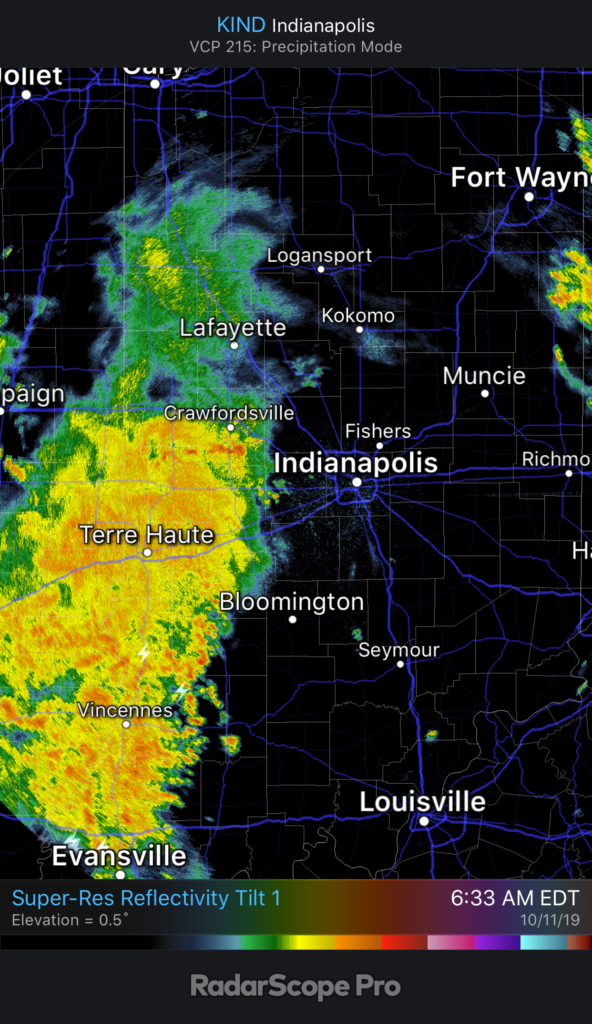
It’ll still be a while before central Indiana gets in on the more concentrated, widespread rain. We think this arrives later this afternoon into the early evening hours. Most can expect to pick up between 0.20” and 0.40” across central parts of the state, but there will be a few locally heavier totals.

Forecast radar 6p Friday.

Before the rain arrives, a strong southerly wind ahead of the front will send temperatures to around 70°. Meanwhile, note temperatures at the same time already into the 40s across eastern IL.

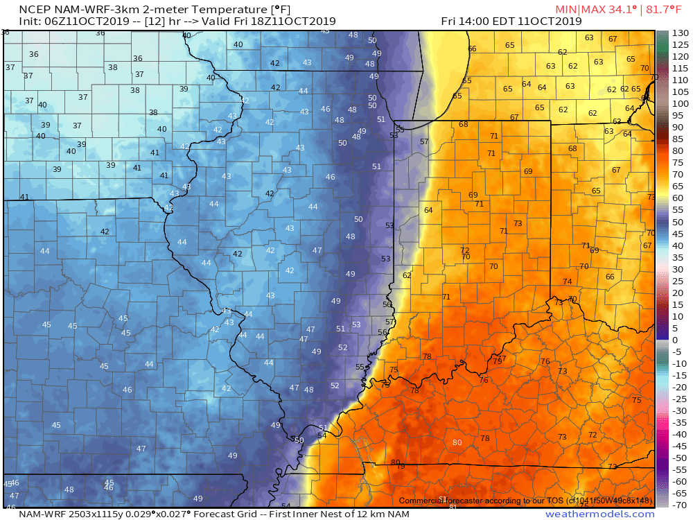
The temperature crash will continue through the evening hours advancing east. By 7p, temperatures in and around Indianapolis and points west will be in the 40s. A gusty wind will result in “feels like” temperatures into the 30s.

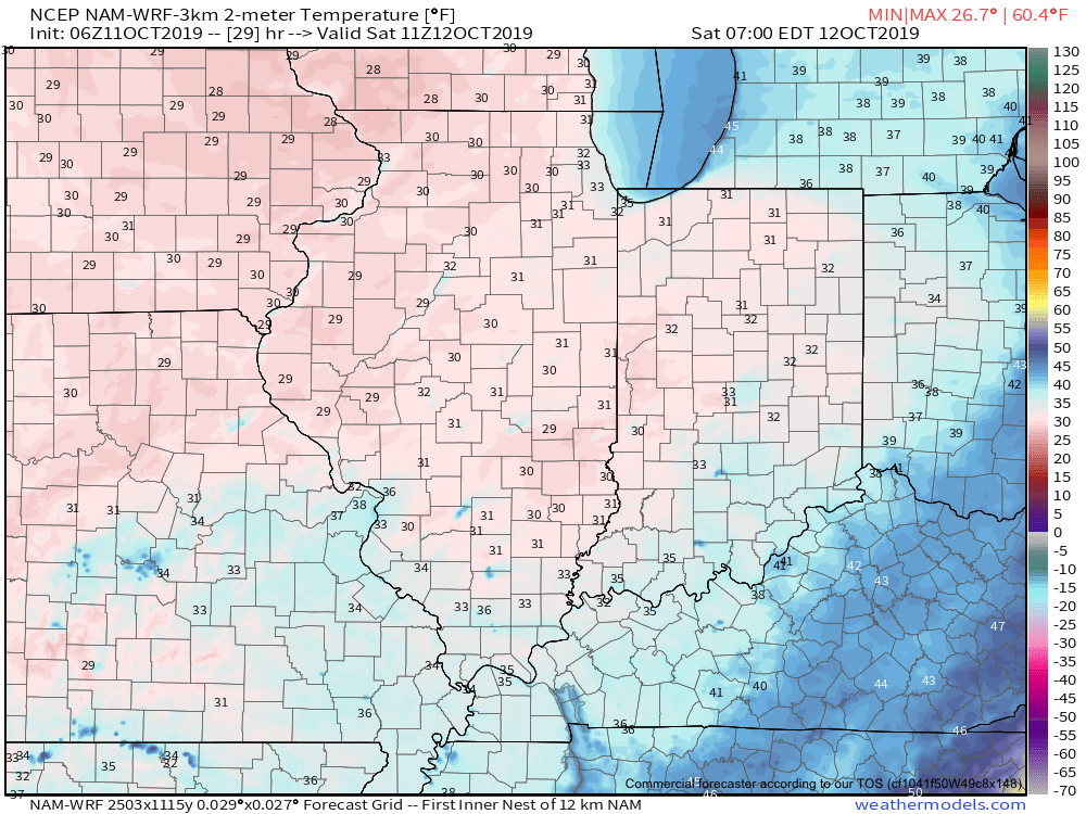
The first freeze of the season is expected Saturday morning for many across central Indiana into western and northern portions of the state. We anticipate wind chill values to fall into the middle 20s.

Another reinforcing shot of chilly air is dialed up next week. More on this and other items a bit later…

Permanent link to this article: https://indywx.com/2019/10/11/first-strong-cold-front-of-the-season/

VIDEO: Friday Will Feature Major Weather Changes Across The Region…

You must be logged in to view this content. Click Here to become a member of IndyWX.com for full access.  Already a member of IndyWx.com All-Access?  Log-in here.

Permanent link to this article: https://indywx.com/2019/10/10/video-friday-will-feature-major-weather-changes-across-the-region/

Cool 6-10 Day Period Ahead, But Then What?

A strong cold front will sweep through the area tomorrow and help usher in the coolest air so far this autumn. This will set the tone, combined with the recurving WPAC typhoon, for a chilly upcoming 6-10 day period, but what lies beyond this period later in the month?

Recurving Super Typhoon Hagibis will promote reinforcing chill across our area next week.

We turn to a couple of our more trusted teleconnections for advice.

Note the PNA “bobbing” up and down through the medium range period, with more of a negative look around the 20th. This argues for a milder stretch of weather around that time. (Further out, we’ll keep close eyes on the PNA to see if a more consistent positive signal develops as we inch closer to November).

The EPO pops strongly positive mid month which, too, argues for milder times, locally. That said, similar to the PNA above, the EPO is trending towards a scenario that would present colder times as we rumble towards November. We’ll monitor for consistency.

To no surprise, given the two primary teleconnection drivers above (remember these can change as the seasons evolve), we see the pattern set to turn milder just beyond Day 10. Note the strong agreement between the European, Canadian, and GFS ensemble data below.

Permanent link to this article: https://indywx.com/2019/10/10/cool-6-10-day-period-ahead-but-then-what/

VIDEO: Pleasant Weather Continues Through Thursday; Sharp Cold Front Delivers Colder Changes For The Weekend…

You must be logged in to view this content. Click Here to become a member of IndyWX.com for full access.  Already a member of IndyWx.com All-Access?  Log-in here.

Permanent link to this article: https://indywx.com/2019/10/09/video-pleasant-weather-continues-through-thursday-sharp-cold-front-delivers-colder-changes-for-the-weekend/

VIDEO: Frosty Weekend? Talking WPAC Typhoon Impacts Downstream…

You must be logged in to view this content. Click Here to become a member of IndyWX.com for full access.  Already a member of IndyWx.com All-Access?  Log-in here.

Permanent link to this article: https://indywx.com/2019/10/07/video-frosty-weekend-talking-wpac-typhoon-impacts-downstream/

Harvest ’19: Weekly AG And Severe Weather Update…

Forecast Period: 10.06.19 through 10.13.19

7-Day Precipitation: Average precipitation is expected through the period.

7-Day Temperatures: Between some wide swings in the temperature department over the upcoming week, things should “balance out” right around seasonal norms when all is said and done.

Severe Weather: We’ll continue to monitor the possibility of a few strong storms Thursday evening into Friday as a potent cold front pushes across the region. A strong southerly flow will help to briefly pull a warmer and moist air mass north across the Ohio Valley and southern Great Lakes and could be sufficient enough to promote strong-severe storms directly ahead of the boundary. We’ll have to fine tune timing in the days ahead, but target the period between late Thursday and Friday afternoon for now.

Frost/ Freeze: A killing freeze will put an end to the growing season across the Plains by late week and the season’s first frost will likely occur for many across the central and northern Ohio Valley next weekend.

Drought Monitor: Abnormally dry areas are still present across portions of east-central IN into Ohio with more widespread droughty areas across KY. Today’s weather system into early Monday will help our friends across southern IN and KY pick up beneficial rainfall.

Summary: A cold front will move through the area today into Monday morning with needed moisture, especially across southern areas of the viewing area. Cooler, drier air will settle into the state as we move through the early portion of the work week before things turn potentially stormy late week ahead of the next strong cold front. The coolest air so far this autumn season will arrive next weekend, including the potential of the first frost for some…

Permanent link to this article: https://indywx.com/2019/10/06/harvest-19-weekly-ag-and-severe-weather-update/

IndyWx.com