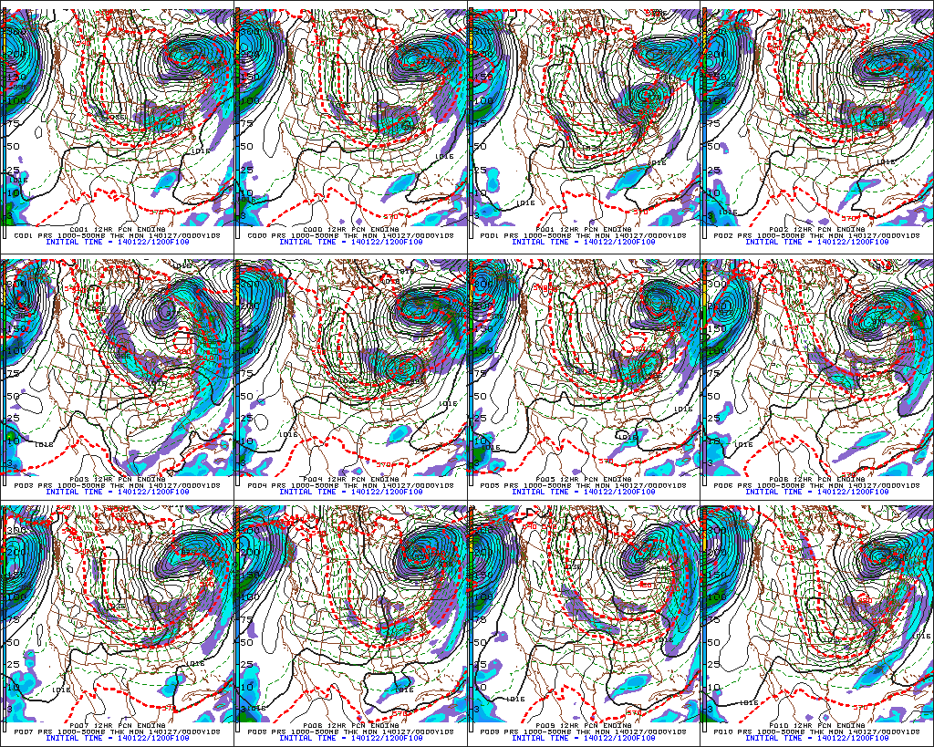
Reviewing The Snowy Details…

After a brief thaw, winter’s set to return with authority in the days and weeks ahead.  In fact, the overall long range weather pattern looks colder and snowier than average into early February, at least.

A current look at the National Radar shows the next clipper system taking shape to our northwest this evening.

usa_None_anim

A dive into the latest model data continues to highlight two distinct opportunities for accumulating snowfall in the days ahead.  The first comes Thursday into Friday while the second (potentially more robust) snow maker arrives Saturday afternoon and evening.  By the way, my hat’s off to the GFS for jumping on Saturday’s system well in advance of the other modeling.  Sometimes it’s easy to hammer the GFS, but it should be pointed out during the model’s shining moments, as well.

Back to the near-term… We think widespread snow overspreads central Indiana Thursday morning and continues through the majority of the day and on into Friday in varied intensity.  By the time all is said and done, 2-4″ of new snowfall will be likely across central Indiana, with some locally higher amounts possible.

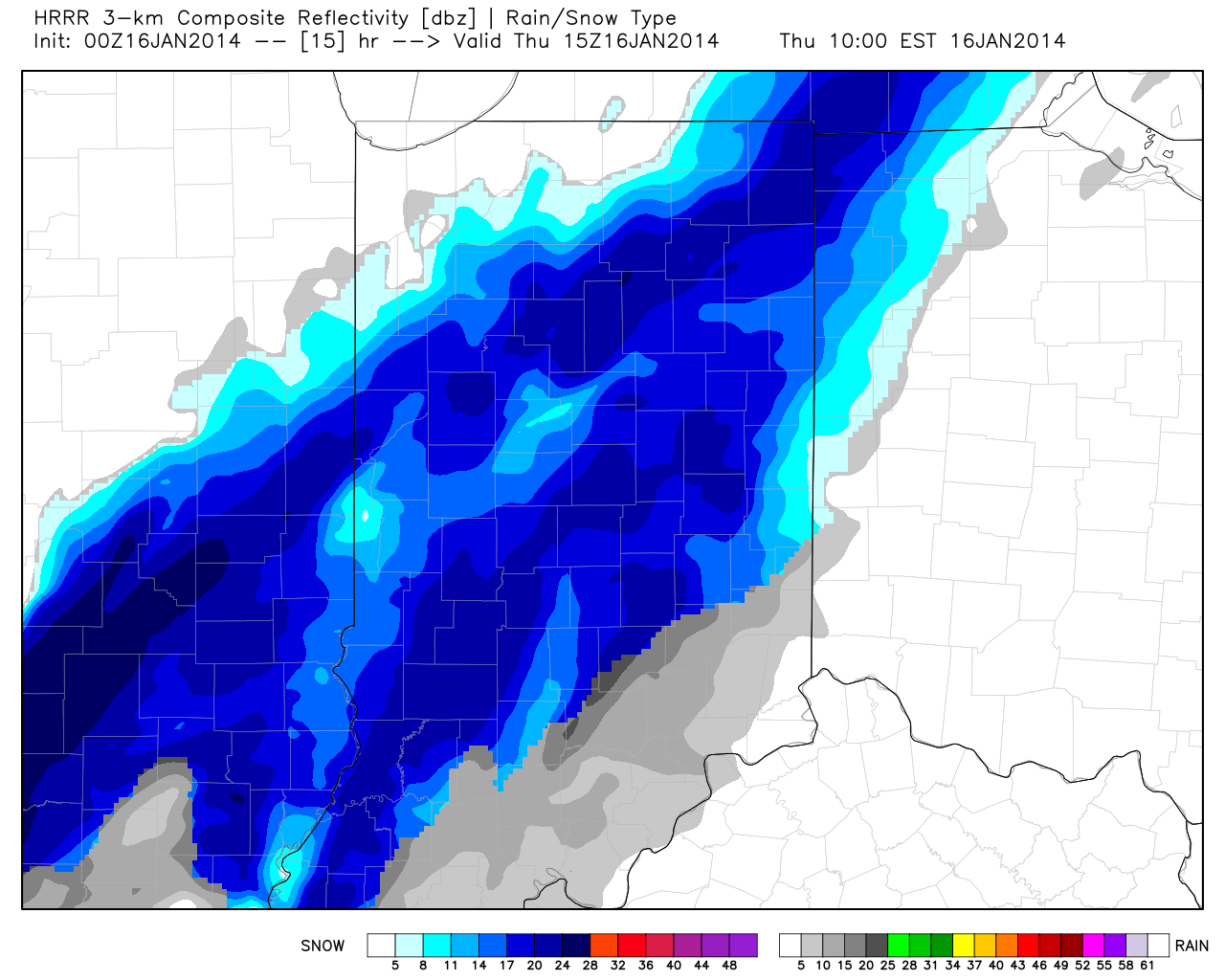
Here’s a look at the latest HRRR simulated radar valid 10am Thursday. Some moderate to briefly heavy snow is possible late morning into the afternoon.

hrrr_ref_indy_16

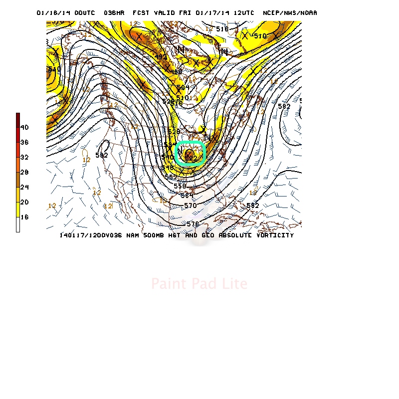
Of interest, we note forecast models carrying a vigorous upper level disturbance across the state Thursday night/early Friday and this will help carry accumulating snow into Friday for some.

500mb

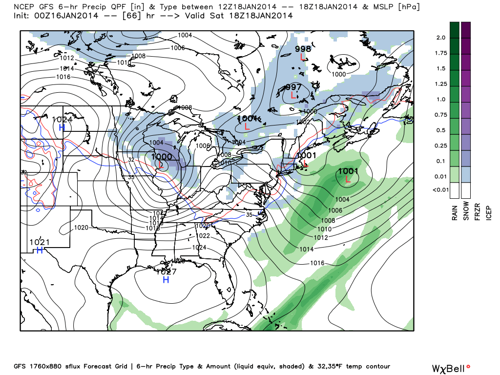
We’ll note an intrusion of briefly drier air Friday afternoon into Saturday morning, but by this time all eyes will be focused on the next clipper system that promises to keep snow shovels and plows busy for parts of Indiana into the weekend.  We think snow overspreads the region from northwest to southeast Saturday afternoon and evening.  Steadiest snow falls Saturday night and could accumulate to the tune of a few inches by daybreak Sunday within the axis of best moisture.  Just to the north of the clipper’s track will be where you find the highest snow totals with Saturday’s system and the precise track of this clipper will be tough to iron out with any sort of certainty until Friday evening.  Stay tuned.  By the way, the snowy and cold events keep on keepin’ on in the longer range…

gfs_ptype_slp_east_12


Cold, Snowy Pattern Reloading…

I sure hope you’ve taken time to get out and enjoy a couple of days of milder air (temperatures have run 10-12 degrees above seasonal levels the past couple days) and even some sunshine.  Given what I see coming down the road, the trend that looks to take a colder turn this week may really go into the tank week two.

Here’s an overview of the latest GFS and ECMWF ensemble data out at Days 8 through 10 (January 21st-23rd).  Both of these, more trusted, mid to long range computer models suggest a cold pattern locks itself into the East once again, and spells for colder than average temperatures and potentially a snowier than normal regime.

test8


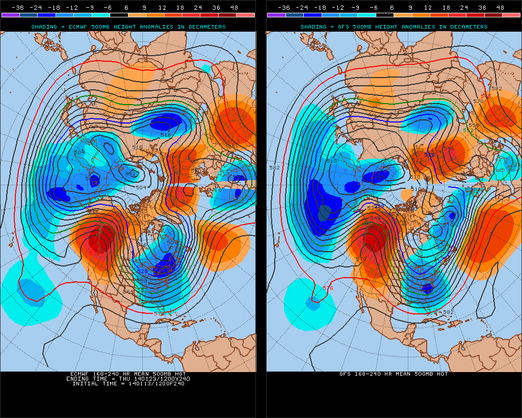
We’ll now dive a little deeper into the forecast model vault, courtesy of the unbelievable Weatherbell Analytics model suite (can’t brag on that company enough).  We’re looking at the Northern Hemisphere Upper Air Pattern, courtesy of the European ensemble control run from this afternoon.

Note the mid week trough set to deliver a return of arctic air into the region.  That’s reinforced with a late week trough and renewed arctic air.  Both cold air masses will be capable of producing light accumulating snow across the area.

Per yesterday’s post, as we get into the early to middle portion of next week, we’ll have to keep a close eye on the potential of the southern and northern branches of the jet stream phasing, which would lead to a significant winter storm across some parts of the eastern half of the country (far too early for specifics or details).

We then note the Polar Vortex recharges itself and threatens to turn the last week to 10 days of January very cold.  How cold is yet to be determined, but I think it’s a safe bet sub-zero temperatures aren’t finished with our area just yet.

Intrusions of very cold arctic air will “pinwheel” around the Polar Vortex and likely lead to a bitterly cold end of January and open to February…

Rare And Potentially Crippling Winter Storm Brewing…

Fresh on the heels of a significant winter storm that impacted central Indiana Wednesday night-Thursday, we’re eyeing our next winter storm and, quite frankly, it could be a memorable one.

We continue to keep a close eye on the pending winter storm Sunday and remain impressed with what we see.  A severe winter storm is brewing and may require blizzard watches and warnings before all is said and done as a combination of heavy snow, strong winds, and severe blowing and drifting promises to make travel difficult, if not impossible, for some areas Sunday.

Setting the stage:

A powerful arctic boundary will drift south towards Indiana Saturday night and Sunday morning.  As this takes place, low pressure will track off the lee of the Rockies and move east, northeast.  Model data continues to suggest this area of low pressure taps into some Gulf of Mexico moisture and really begins to deepen (strengthen) as it tracks into the central/ eastern Ohio Valley Sunday.  To the northwest of the low’s track, a deep blanket of fresh snow will fall.  As the winter storm departs, the coldest air since 1994 will pour into the region on a gusty northwest wind.  Temperatures will reach record territory, and downright dangerous levels, by Monday and Tuesday.

Last night we mentioned a couple of things going “for” and “against” a major winter storm here in central Indiana.  While there’s no doubt going to be a sharp “cut off” of heavy snow with this storm, this “cut off zone” is most likely well north and west of central Indiana.  Additionally, the impressive thermal gradient between the brutal arctic air mass to the north and the warmer air (relatively speaking) to the south and east will only add fuel to a deepening storm moving northeast into the Ohio Valley.  Finally, with arctic air pouring into the region, the “fluff effect” will be in full-go mode, meaning the northwest flank of the heavy precipitation is likely to have snow ratios of 15:1 as compared to the “normal” 10:1 ratio.  This will be very important to watch as the system develops and will most likely be the spot (far too early to pinpoint at this juncture) where snowfall amounts in excess of one foot will fall.

All of our medium range model data is in agreement on central Indiana receiving quite the blow from Old Man Winter Sunday.  Here’s a look at the latest GFS, European, and Canadian forecast models, valid Sunday afternoon:

GFS1EC1CMC1


As you can see, there’s excellent agreement and this leads to a rather high confidence idea on a high-impact and rather rare severe winter storm set to impact Indiana.  Can we tell you with certainty exactly where the 12″+ band of snow will lie across the state?  Not at this time.  That said, we suggest preparing now for a rare and potentially crippling winter storm Sunday.  The combination of heavy snow, strong winds, historic cold, and severe blowing and drifting will make for an extremely dangerous situation Sunday, continuing into early next week.  Temperatures by Tuesday morning will approach 20 degrees below zero, with wind chill values plummeting to 40-50 degrees below zero Monday into Tuesday…

Major Storm Brewing This Weekend, But Details Are Murky…

During the late summer and early autumn months we were trying to look at the big picture and potential drivers in the overall weather pattern for the upcoming winter and openly admitted the challenges that were ahead.  Here we are now into the second half of December and a much colder and snowier-than-average month is a virtual lock at this point.  Furthermore, consider this has all taken place without the presence of a favorable NAO or PNA.  Sometimes you have to look for other drivers in a pattern- in this case, the EPO, as well as a growing early fall snow pack across the border to our north.  Additionally, we made mention of the likelihood of a southeast US ridge periodically making itself known through the winter of ’13-’14.  You can read all of our thoughts posted earlier this fall here, or by clicking the Thoughts On Winter ’13-’14 page above.

As we look ahead towards the upcoming wintry challenge, we’re confident of the overall pattern, but the sensible weather that’ll ensue is still up for great debate.  “Gut” tells me central Indiana will be looking at a rain to freezing rain scenario, but this is far from set in stone, and sometimes forecasters who go simply off their instinct can get burned.  The pattern is one that (once again) will feature a pressing arctic front against resistance from the southeast US ridge.  With this type of scenario, I would advise against looking at each and every individual operational model run, but instead invest time studying the ensembles- an average of several multiple model runs as opposed to just one operational model run.   I can guarantee a variety of wild solutions ahead in the days to come, based off the operational runs. (Heck, just the past 24 hours have been reason enough to have the dramamine on hand :-)).  That said, let’s take a look at the latest GFS and European ensembles, two models that we rely heavily on in the mid range weather pattern.

First, the GFS, valid Saturday through Monday.

f120f144f168

Now, here’s a look at the latest European ensembles (left), again valid Saturday-Monday.

Geopotential32at32500hPa_North32America_120Geopotential32at32500hPa_North32America_144 Geopotential32at32500hPa_North32America_168

So what do all of these cool maps tell us?  Simply put, that “wintry mischief” is brewing for the weekend.  That much we know, but the details have to be ironed out.  It’s likely heavy snow and a significant ice storm looms for some of the Mid West and Ohio Valley for the upcoming weekend.  Is that Indianapolis or Chicago?  Perhaps in between?  It’s too early to know.  Additionally, in the “warmer” sector, heavy rains are likely to combine with an impressive early season snow pack for some to lead to flooding concerns.

A couple of additional items to note. Many times at this stage in the game (still 5+ days out) with this type of pattern, forecast models really struggle with handling low level cold air.  Cold air is very dense and, in this type of set up, can easily drain much further east and south than forecast at this juncture.  Additionally, sometimes the modeling can put too much “umph” into the associated surface wave that moves along the arctic front resulting in a further north track than what may actually occur when the event draws closer.  Just something to keep an eye on as we draw closer…

Needless to say, it’ll be particularly important to keep a close eye on the developing weekend forecast as we move forward.  It’s likely folks in the Ohio Valley region have to deal with significant precipitation amounts in the Saturday-Monday time period, including rain, freezing rain, and snow.