Category: Freezing Rain

Bitter Times Ahead; Weekend Storm…

screen-shot-2016-12-13-at-6-20-11-pmHighlights:

  • Bitterly cold
  • Weekend storm delivers a little bit of everything
  • Cold reloads over the weekend

Cold That Hurts…Tuesday was a snowy day across central IN. Most snow reports checked in around 3″, but there were a few “lucky” folks who accumulated north of 4″.  Not bad at all!

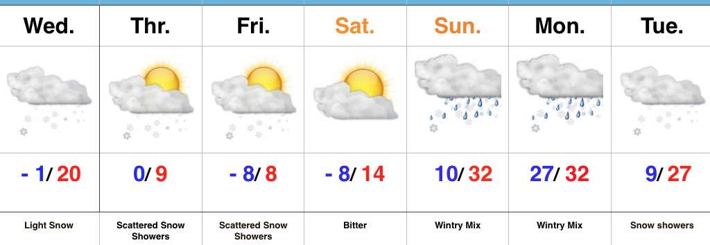
Two pieces of arctic air will invade mid week.  The first piece is arriving on the scenes as we type this forecast Tuesday evening.  It’ll send lows into the single digits to lower teens by Wednesday morning.  Patchy freezing fog will also be noted in spots.  Needless to say, don’t get too confident on area roadways.  Despite the phenomenal work central IN road crews do (seriously, thank you), there will be icy spots tonight and Wednesday morning.  Slow down!  🙂

A second surge of arctic air will arrive Wednesday afternoon and evening.  Everyone gets in on the single digit party Wednesday night and Thursday morning.  In fact, don’t be surprised by a few folks checking in with a below zero report here and there.  Winds will be strong and gusty and lead to wind chill values of 10-20 below zero into Thursday morning.  Heavy winter attire will be required.

Our attention then shifts to a developing weekend storm that will deliver a wintry mix late Friday followed by a transition to rain as temperatures zoom (briefly) into the 40s Saturday.  The milder surge won’t last long as arctic air oozes back into central parts of the state Saturday afternoon and evening.  As this is happening, a second wave of moisture will ride up along the arctic front.  We expect rain to mix with and change to a wintry mix of sleet and freezing rain before ending as snow Saturday night/ early Sunday morning.  This may be another accumulating wintry event and we’ll keep a close eye on things.

Cold, dry weather will be with us as we kick off Christmas week.  Speaking of Christmas week, the bitterly cold air will “relax,” but the pattern remains active.  Despite the relaxation in the frigid times, conditions will remain cold enough for wintry potential leading up to, or around, Christmas…

Upcoming 7-Day Precipitation Forecast:

  • Snowfall: 1″ – 3″
  • Rainfall:  0.25″ – 0.50″

Permanent link to this article: https://indywx.com/bitter-times-ahead-weekend-storm/

Snowy Tuesday; Bitter Mid Week Ahead…

screen-shot-2016-12-12-at-5-55-48-pmHighlights:

  • Snowy Tuesday
  • Bitter Mid Week
  • Weekend Storm

Accumulating Snow Event…Upper energy will combine with an approaching arctic front to lead to an accumulating snowfall event for many across central Indiana Tuesday.  We expect snow to increase in coverage and intensity just prior to sunrise before turning moderate to briefly heavy from mid to late morning on into the early afternoon hours.  In general, we paint a band of 1″-3″ through the heart of central Indiana, but do have some concerns localized banding features could result in a 4″ pop here and there (impossible to pinpoint the precise locations these bands may set-up across central IN as of this update).  Expect a messy morning commute.

121316snowfallforecastFresh arctic air will pour into the region tomorrow evening, along with a gusty NW wind.  Tuesday’s snow should be rather wet in nature so we don’t anticipate blowing/ drifting issues to result as the arctic hounds roar into town.  However, there will likely be periods of flurries and scattered snow showers as the bitterly cold air arrives in the Wednesday-Thursday time frame and this could lead to light additional coatings in spots.  The big weather story through mid and late week will be the bitter air.  “Air that hurts” is what we’re calling it and wind chill values will approach 20 degrees below zero Wednesday night/ Thursday morning.

Our next storm system is still slated to arrive for the weekend.  As of now we forecast snow and a wintry mix Friday evening.  This will then change to rain Saturday before arctic air quickly oozes back in here and leads to a potentially messy Saturday night-Sunday morning.  Rain will transition to freezing rain and sleet Saturday evening before ending as a period of snow.  It’s back to the ice box we’ve come to know all too well Sunday into Monday.

Upcoming 7-Day Precipitation Forecast:

  • Snowfall: 2″ – 5″
  • Rainfall: 0.50″

Permanent link to this article: https://indywx.com/snowy-tuesday-bitter-mid-week-ahead/

VIDEO: Thanksgiving Weather; “Interesting” Open To December…

You must be logged in to view this content. Click Here to become a member of IndyWX.com for full access.  Already a member of IndyWx.com All-Access?  Log-in here.

Permanent link to this article: https://indywx.com/video-thanksgiving-weather-interesting-open-to-december/

Messy Monday Morning Commute; Watching Tuesday…

Screen Shot 2016-02-14 at 9.45.26 PMHighlights:

  • Freezing drizzle to start the day
  • Watching another storm system Tuesday
  • Mild and windy close to the week

Messy Monday Morning Commute; Watching Tuesday…After the snowy Valentine’s Day across the region, we’re concerned freezing drizzle will develop and add to what already will be a slick commute in spots overnight and Monday morning. Allow extra drive time and take it slow.

Attention will quickly shift to Tuesday as a vigorous piece of upper level energy dives southeast. We have to fine tune the track later Monday, but this has the potential to spread a swath of accumulating snow over portions of the state Tuesday afternoon and evening.  Stay tuned.

We turn windy, but much milder to wrap up the work week. Friday and most of the weekend will feature a taste of spring as a strong SW flow takes hold and helps pump well above normal temperatures into the area.  Don’t get used to the mild air, as cold will return to wrap up Feb and head into March.

Interested in our consulting services?  E-mail bill@indywx.com for more information.

Permanent link to this article: https://indywx.com/messy-monday-morning-commute-watching-tuesday/

Strong Winds; More Heavy Rain…

Screen Shot 2015-12-28 at 7.38.21 AMHighlights:

  • Strong winds and flood threat continues
  • Weak mid week system
  • Much colder to open the New Year

Strong Winds And Flood Threat Remains…What an active morning across central IN!  Northeast winds are already gusting around 40 MPH with periods of heavy rain this morning.  Across our northern tier of counties (mainly north of a line from LAF to KOK) freezing rain and sleet is the issue this morning with temperatures below freezing.

Periods of heavy rain will continue today, and we also note the threat of embedded thunder (damaging wind risk) this evening, bracketed between the hours of 6p-8p.

Image below is courtesy of Weatherbell.com

StrongWindsTemperatures will remain cold and raw through most of the day before we see a late day rally briefly into the lower to middle 50s.  It’ll be another day with a tight temperature gradient across the state, as northern IN will struggle to make it much above freezing, while southern IN approaches the upper 60s this evening.

Midnight highs Tuesday can be expected before temperatures crash.

We’ll then set our eyes towards a weak wave of low pressure that looks to deliver a light mixed bag of precipitation Wednesday morning.  The freezing line will run through the central part of IN and a mixture of light snow and light rain can be expected.  MUCH colder air flows into the state behind this system and sets the stage for a cold open to 2016.

Image below is courtesy of Weatherbell.com

WednesdayForecast models continue to show an expected pattern shift to all-out sustained cold and wintry conditions for mid and late winter.  Note the W NA ridging developing.  Additionally, blocking and a negative AO develop as mid January nears.  Think this is the year without a winter?  Better think again, my friends.

Image below is courtesy of Tropicaltidbits.com

MidJan2016

Permanent link to this article: https://indywx.com/strong-winds-more-heavy-rain/