Category: Forecast

Beauty Of A Sunday…

Screen Shot 2016-04-24 at 11.14.16 AMHighlights:

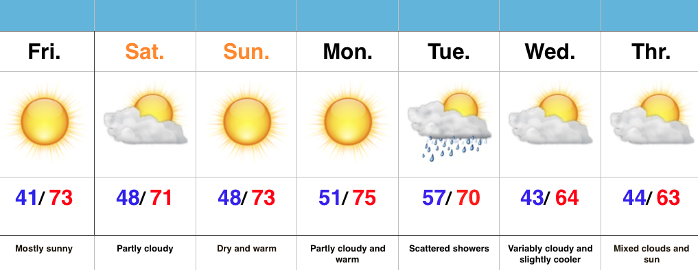
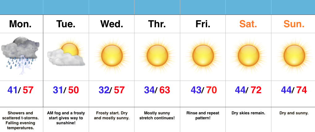
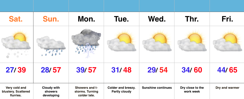
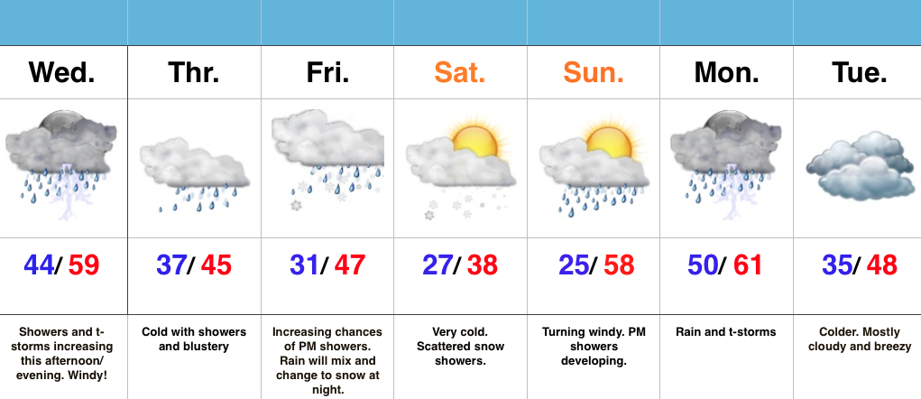
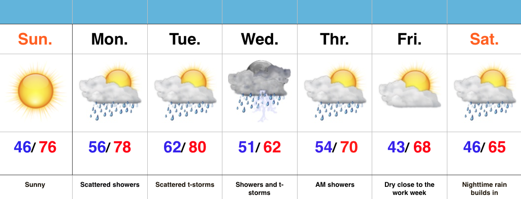
  • Sunny close to the weekend
  • Warm and increasingly humid early week with showers
  • Widespread rain and storms Wednesday
  • Significant rain maker to open May

Good Supply Of Vitamin D…High pressure will remain in control of our weather today and supply mostly sunny skies and warm temperatures.  Get outside and enjoy!

Moisture will begin to increase as we progress through the early portions of the work week with showers and scattered thunderstorms developing Monday into Tuesday.  We’ll still enjoy lots of dry time in between the scattered showers.

More widespread showers and thunderstorms will push into the state Wednesday.  Early numbers suggest amounts of 0.75″-1″.  Lingering showers remain Thursday morning, but we should get a nice push of dry air in here Thursday afternoon into Friday.

Attention will then shift to a significant system that promises to provide heavy rain and embedded thunderstorms as early as Saturday night.  We still have time to watch this, but from this distance it appears as if this will be a “juicy” storm system.  We’re also eyeing a much cooler open to May…

Permanent link to this article: https://indywx.com/beauty-of-a-sunday/

Sun-Filled Weekend…

Screen Shot 2016-04-15 at 7.45.25 AMHighlights:

  • Dry times continue
  • Warmer days ahead
  • Weak system arrives Tuesday

Have The Sunglasses Handy…There’s no reason to waste many pixels on this forecast as a ridge of high pressure remains in firm control of our weather, keeping us dry and mostly sunny through the weekend.  A weak swirl in the atmosphere will provide a few clouds and a spotty sprinkle across far southern IN today.  Otherwise, sunny and warm times remain through the weekend into early next week.

A weak weather maker will provide scattered showers by Tuesday, but this doesn’t look like a big deal from this distance.

Permanent link to this article: https://indywx.com/sun-filled-weekend/

This Is More Like It…

Screen Shot 2016-04-11 at 9.51.07 AMHighlights:

  • Wet open to the work week
  • Shot of colder air
  • Extended dry, sunny stretch coming

Good Supply Of Vitamin D Coming…While the work week is opening cloudy, wet, and gloomy, it certainly won’t end that way.  Rain will end from west to east this afternoon.  Before we get into the much deserved pattern change later this week, we’ll deal with one more shot of chilly air arriving tonight and Tuesday with a brisk NW wind.  Sub-freezing temperatures are a good bet for most Tuesday and Wednesday mornings.

Once to Thursday, we’re “off to the races” as far as temperatures go- adding a couple degrees on afternoon highs each afternoon.  Wall-to-wall sunshine will dominate the forecast as we wrap up the work week and head into the weekend.  Enjoy, friends!

Permanent link to this article: https://indywx.com/this-is-more-like-it/

Bitterly Cold By April Standards…

Screen Shot 2016-04-09 at 8.09.05 AMHighlights:

  • Cold times continue
  • Rain arrives Sunday
  • Monday storms
  • Slowly moderating late next week

Bundle Up…With temperatures in the middle and upper 20s this morning and ‘chills in the 10s, it’s hard to believe we’re nearing mid-April!  It’s simply downright bitter by April standards.  Early snow showers and flurries should diminish as we progress into the afternoon hours with decreasing cloudiness, as well.

Dry times won’t last long as a warm front approaches Sunday.  This will deliver a thick overcast back to the region, along with developing showers and embedded thunder into Monday.  Early rain numbers into the forecast office offer up the potential of 0.75″-1.25″ on average in the Sunday-Monday time period.

We’ll turn colder and breezy (surprise, surprise) Monday night into the middle of the week, BUT moderating temperatures will develop by late week!  60s are in store for afternoon highs Thursday-Friday with lots of sunshine!  Hang in there, friends!

Permanent link to this article: https://indywx.com/bitterly-cold-by-april-standards/

Cold And Unsettled Pattern…

Screen Shot 2016-04-06 at 8.01.25 AMHighlights:

  • Increasing rain chances today
  • Turning colder and continued unsettled to wrap up the work week
  • Snow showers Friday night-Saturday
  • Wet start next week

Active Times Continue…Despite some thunderstorms across northern portions of the state this morning, most are dry.  That will change this afternoon and evening as widespread showers and embedded thunder increase in coverage.  On average, expect 0.25″-0.50″ by tonight.  Winds will also be gusty (40 MPH+).

We’ll shift into a much colder pattern to wrap up the work week and upper level energy will help produce showers Thursday.  As even colder air gets involved, rain will transition to snow Friday night into Saturday morning.  Saturday will be downright cold.

Another wet weather maker approaches early next week.  After a hard freeze Sunday morning, things will cloud up, turn windy, and feature evening showers.  More widespread rains and storms arrive on the scene Monday.  Colder air returns Tuesday!

Permanent link to this article: https://indywx.com/cold-and-unsettled-pattern/