Category: Forecast
Highlights:
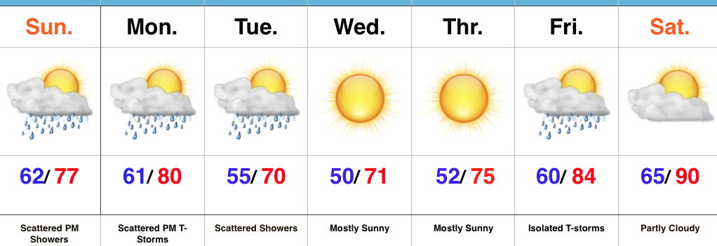
- Scattered PM shower/ storm threat through early week
- Cool, sunny mid week
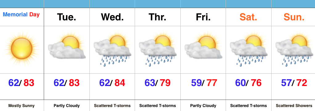
- Heat cranks next weekend
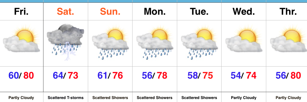
Turning Cooler By Midweek…After a significant rain event (on average 0.75″-1.4″ fell across central IN) Saturday, we’re starting our Sunday morning off with partly-mostly cloudy skies. A much less humid brand of air will build in today, but we can’t completely shake the rain chances. A scattered afternoon shower is possible.
Reinforcing cooler air will move in Monday and the associated boundary will likely do a better job kicking off scattered shower and thunderstorm activity as it moves through the region.
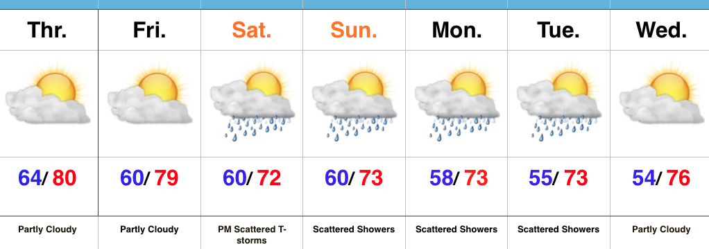
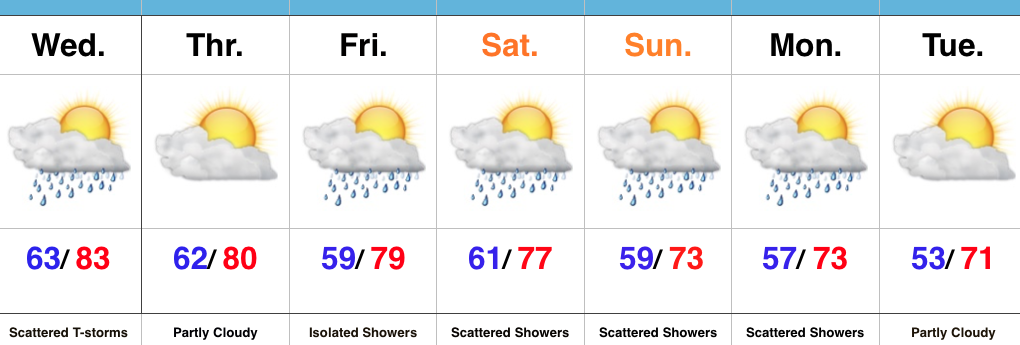
We’ll turn much cooler and refreshing for mid week, along with lots of sunshine and dry conditions. As you’d imagine, the refreshing air doesn’t last long this time of year and a SW flow will help temperatures and moisture levels surge to close the work week. The hottest air of the year so far is slated for next weekend.
Upcoming 7-Day Precipitation Forecast:
- 7-Day Snowfall: 0.00″
- 7-Day Rainfall: 0.25″-0.50″
Permanent link to this article: https://indywx.com/turning-less-humid-today-much-cooler-mid-week/
Highlights:
- Beautiful Friday!
- Rain and thunder returns Saturday
- Cooler early next week
TGIF…The best weather day of the week has saved itself for Friday. Find a way to get outside and enjoy it! After a delay in the arrival of drier air, we’ll (finally) tap into lower dew points tonight into the day Friday, but it’ll be short-lived. Increasingly moist air will return as early as overnight Friday into Saturday. Drizzle and showers could accompany a warm front lifting north through the region during the wee morning hours Saturday. Additionally, thunderstorms are possible Saturday afternoon and evening as an upper trough surges southeast into the Ohio Valley.
The region will remain in a cooler, northwest flow pattern into early next week. With plenty of upper level energy around, showers are possible (scattered in nature) during the afternoon hours into Tuesday. Drier air will allow for partly cloudy skies to return to the forecast by mid week.
Upcoming 7-Day Precipitation Forecast:
- Snowfall: 0.00″
- Rainfall: 0.50″-1.25″
Permanent link to this article: https://indywx.com/best-day-of-the-week-arrives-friday/
Highlights:
- Drier close to the work week
- Strong storm chance Saturday PM
- Unsettled and cooler early next week
Turning Cooler Over The Weekend…A cold front tapped into available moisture and resulted in locally heavy rain Wednesday afternoon and evening. In some spots, as much as 2″ of rain fell in a very short period of time. We’ll begin to dry things out to wrap up the work week, along with partly cloudy and less humid conditions.
An upper trough will dig into the Ohio Valley Saturday and could help spark strong to potentially severe thunderstorms for portions of the region Saturday afternoon and evening. We’ll keep a close eye on things over the next day or two.
We’ll turn significantly cooler over the weekend into early next week. With plenty of upper level energy around the region, we’ll have to mention the chance of a scattered shower into early next week. Dry conditions return by the middle of next week.
Upcoming 7-Day Precipitation Forecast:
- Snowfall: 0.00″
- Rainfall: 0.50″-0.75″
Permanent link to this article: https://indywx.com/drier-close-to-the-work-week-unsettled-cooler-weekend/
Highlights:
- Scattered Midweek Storms
- Cooler and unsettled this weekend
- Cooler than average open to next week
Haves And Have Nots…A cold front will move through the region Wednesday evening and result in scattered showers and thunderstorms, especially in the afternoon and evening hours. While there will be some localized heavy downpours, not everyone can expect heavy rain tomorrow. We’ll note a wind shift and drier air Thursday.
As we progress into the upcoming weekend, a trough will begin to carve itself out over the region. Not only will this provide a cooler air mass, but multiple upper level disturbances will track through the region, helping keep things rather unsettled at times this weekend into early next week. While we’re not talking about heavy rain, there will be rainy periods at times as these pieces of upper level energy move through.
Upcoming 7-Day Precipitation Forecast:
- Snowfall: 0.00″
- Rainfall: 0.50″-1.00″ (locally heavier totals)
Permanent link to this article: https://indywx.com/local-downpours-wednesday/
Highlights:
- Sunny, warm Memorial Day
- Scattered storms mid week
- Cooler late in the forecast period
Sunscreen and Sunglasses needed…High pressure will supply plenty of sunshine for Memorial Day. While it’ll be warm, it’ll be a little less humid than the past few days. All-in-all, it’ll be a great day to be outdoors. Enjoy it!
A cold front will move closer to the region come midweek and tap into available Gulf moisture to create a good chance of scattered showers and thunderstorms Wednesday PM into Thursday.
Come late week, modeling differs on the precise details. For now, we’re leaning towards a cooler, unsettled look. Fine tuning will be required as we move forward.
7-Day Precipitation Forecast:
- Snowfall: 0.00″
- Rainfall: 0.25″-0.75″
Permanent link to this article: https://indywx.com/beautiful-memorial-day-weather/