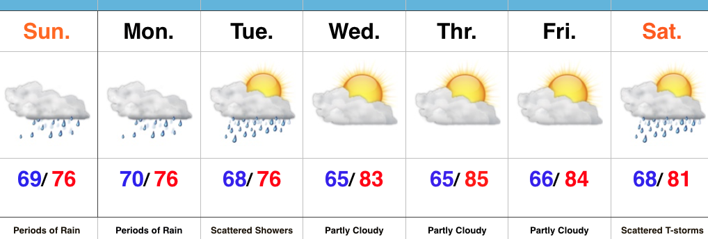
Category: Forecast
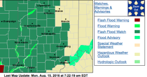
The National Weather Service has expanded the Flash Flood Watch to encompass more of the viewing area. This is in effect until 8p Tuesday.
No doubt about it, today will be very wet across the entire region, including periods of heavy rain- especially across the western half of the state.

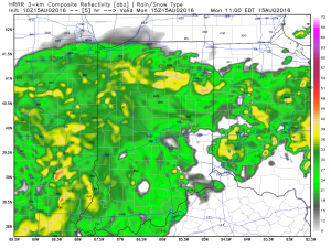
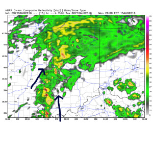
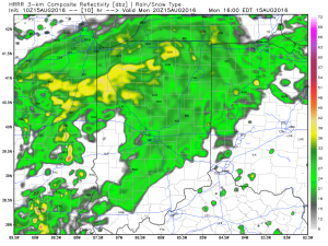
Tropical moisture will continue to stream into the state tonight into Tuesday. In fact, most intense rains will likely set up tonight and may feature “banding” signatures that would train over the same areas. Within these intense rain bands, prolific rainfall rates can be expected, enhancing the flash flood risk. Latest short-term model data shows this threat, and would place a premium focus on areas generally west of US-31. We’ll have to keep a close eye on things.
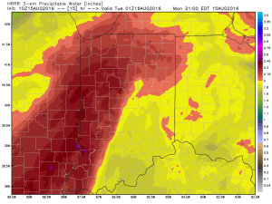
Plenty of “juice” is available to tap into across western sections tonight. Precipitable water values (PWATs) of 2″-2.5″ will be more than enough to fuel torrential rainfall.
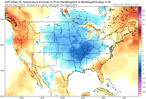
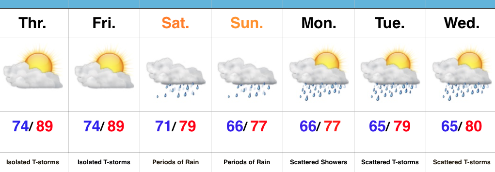
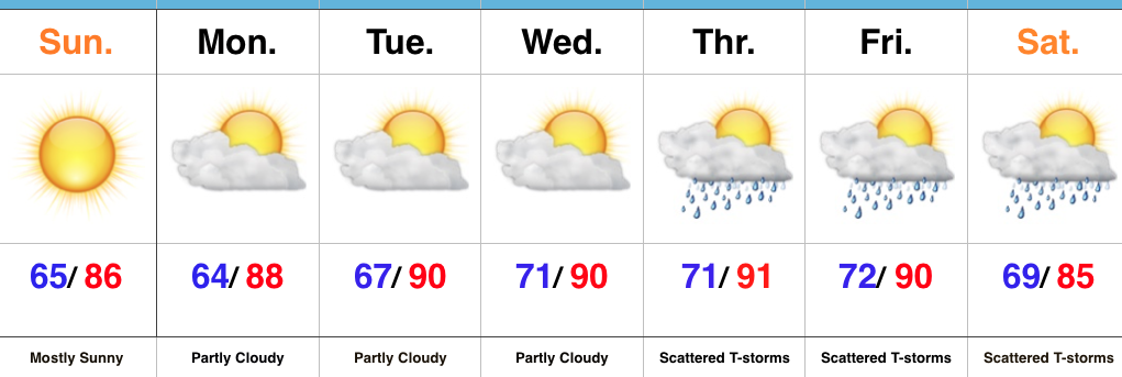
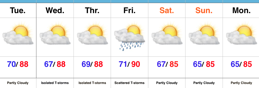
Eventually (mid and late week), we’ll dry things out and a significant cool down is still in store developing this weekend into early next week. Lows will fall deep into the 50s with highs only in the 70s. Talk about an early taste of fall…

Permanent link to this article: https://indywx.com/wet-day-enhanced-flood-risk-tonight-for-some/
Highlights:
- Periods of heavy rain
- Drying out come mid week
- Cold front arrives next weekend
Flooding Concerns…Renewed heavy rain is pushing through central IN as we write up the morning forecast package. This conveyor belt of moisture will continue to lift northeast and eventually break up and diminish during the late morning and early afternoon. Despite scattered showers this afternoon, drier times will ensue, overall. Unfortunately, this drier period won’t last long as another slug of moisture lifts north late tonight and continues Monday. Additional heavy rainfall can be expected, including the potential of rainfall rates approaching 2″+/ hour. Given the water-logged soils across the region, concerns of flash flooding are very high Monday.
Eventually, we’ll dry things out come mid week and introduce more sunshine back into the forecast. Our next item on the agenda will be a cold front that will sweep through the state Saturday. Scattered showers and thunderstorms will accompany the boundary as it moves through the region before much drier and cooler air blows in for the second half of the weekend. In fact, a welcomed early fall preview awaits come Sunday. Thoughts of football, pumpkin “everything,” bonfires, and apple cider will be prevalent this time next week…
Upcoming 7-Day Precipitation Forecast:
- Snowfall: 0.00″
- Rainfall: 2″-4″ (locally heavier totals)
Permanent link to this article: https://indywx.com/heavy-rain-continues-early-fall-preview-late-next-weekend/
Highlights:
- Tropical feel
- Heavy weekend rains
- Unsettled early next week
Zoning In On Heaviest Rains…It’s about as humid as it can get across central IN. “Air you can wear” is the appropriate way to describe this humidity and overall sultry feel. As we’d expect with this tropical air mass, isolated to widely scattered strong storms could pop at any point and result in locally heavy rain. We’ll “rinse and repeat” today’s forecast to wrap up the work week.
Attention then shifts to a widespread soaking rain event this weekend as two main players “team up” to produce a localized flood threat. A cold front will sag into central IN while remnant tropical moisture slowly moves north and eventually curls northeast. Precisely where the front stalls in response to the tropical low moving north will be where heaviest (4″+) rains set up. Thinking this morning places the greatest risk somewhere between Indianapolis and Louisville, but we caution that we still want to see a couple more model runs before settling on a given area. Unsettled weather will likely continue into early next week as tropical moisture slowly exits stage right.
Longer term, indications point towards an overall cooler, wetter, back half of August. Times- they are ‘a changing!
Upcoming 7-Day Precipitation Forecast:
- Snowfall: 0.00″
- Rainfall: 2.00″-4.00″
Permanent link to this article: https://indywx.com/a-wet-weekend-in-store/
Highlights:
- Sun-filled days
- Heat cranks up
- Late week questions
Turning Up The Heat…After a refreshing weekend, the heat returns later this week. Look for highs in the lower 90s with an oppressive feel to the air, as humidity builds. “Air you can wear” will be an appropriate forecast title come mid week. The forecast is easy through the midweek stretch with sunshine as the rule.
Things become more unclear as we approach the back half of the week and the weekend. We note the GFS is rather progressive in swinging a cold front through here with scattered showers and thunderstorms, followed by a significantly cooler/ drier air mass a week from today. On the other hand, the European solution is drastically different as it slows the front to a “crawl” coming through the Ohio Valley and also entrains GOM (Gulf of Mexico) moisture from the serious rain/ flood maker later this week across the Gulf states. It’s a significantly wetter look, locally, and a situation we’ll continue to keep a close eye on in the coming day, or two.
Upcoming 7-Day Precipitation Forecast:
- Snowfall: 0.00″
- Rainfall: 0.50″-1.00″
Permanent link to this article: https://indywx.com/dry-and-turning-hot-watching-late-week/
Highlights:
- Lots of sunshine
- Best storm chances Friday this week
- Turning less humid this weekend
Sunglasses Required…The storm axis has set itself up to our west, including IA and MO. At one point, data and upper level steering currents seemed to align in a manner that would be further east, but that’s obviously not the case. The end result here will be a drier forecast, overall. We’ll still have to remain on our toes for storm potential through week’s end, but the confidence is low and the drier regime looks good this morning.
Less humid air will push in this weekend, along with continued sunny conditions. All in all, the first weekend of August looks very pleasant. Plans to go to the State Fair anyone?
Upcoming 7-Day Precipitation Forecast:
- Snowfall: 0.00″
- Rainfall: 0.25″-0.50″ (locally heavier totals)
Permanent link to this article: https://indywx.com/lots-of-sunshine/