Category: Forecast
Highlights:
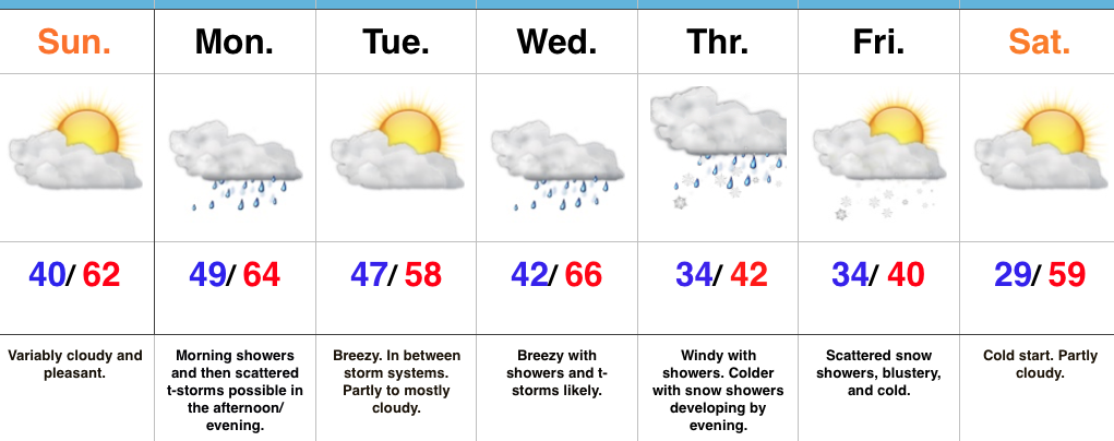
- Pleasant close to the weekend
- Rainy open to the work week
- Turning colder with rain and snow late week
Sunshine Gives Way To Rain…The weekend will end on a pleasant note as weak high pressure provides a variably cloudy sky today. That early-April sunshine will help temperatures top out in the lower 60s this afternoon.
Clouds will increase tonight and showers will develop during the overnight period. We’ll add a little instability to the mix by afternoon and introduce thunderstorms into the forecast Monday afternoon and evening. This storm system will then exit just as quickly as it arrives Monday night and help set up a pleasant Tuesday.
Eyes will then shift to a stronger storm system that will bring widespread showers and thunderstorms Wednesday, with locally heavy rain a good bet. As the storm wraps up over the Great Lakes region late week, colder air will spill into the state on gusty northwesterly winds. Backlash, wind-whipped, rain showers will transition to wet snow showers Thursday into Friday as colder air settles in. The good news here is that the weekend will get off to a nice start…after a cold beginning Saturday morning.
Upcoming 7-Day Precipitation Forecast:
- Snowfall: 0.00″
- Rainfall: 2.00″ 2.50″ with locally heavier totals
Permanent link to this article: https://indywx.com/active-week-of-weather-ends-wintry/
Highlights:
- Nice weekend
- Rain returns Sunday night-Monday
- Strong storm potential Wednesday PM
- Cold close to the week
Sunshine Should Make An Appearance Today…The weekend is opening chilly, including wind chills around freezing this morning. Hang in there- sunshine should at least make an appearance later on this afternoon and Sunday certainly looks to be a brighter day, overall, before clouds increase late and give way to showers overnight into Monday morning.
We’re back to sunshine Tuesday before a stronger storm begins to impact the state Wednesday. A rather robust area of low pressure will track into the Great Lakes region Wednesday night and help pull a briefly warmer, increasingly moist air mass into the area. Potential is present for strong to severe thunderstorms Wednesday evening into the nighttime. We’ll then transition to a much cooler regime to close the week and with low pressure slowly pivoting through the Ohio Valley, showers will continue Thursday into Friday. In fact, the air may grow cold enough to allow for a few wet snowflakes to mix with the rain by Friday morning.
Upcoming 7-Day Precipitation Forecast:
- Snowfall: 0.00″
- Rainfall: 1.75″ – 2.25″
Permanent link to this article: https://indywx.com/quiet-weekend-gives-way-to-an-active-work-week/
Highlights:
- Wet, chilly close to the work week
- Dry weekend
- Couple storms and turning colder late next week
Busy Weather Pattern Continues…An area of low pressure is swirling overhead this morning and will help promote periods of showers into the early afternoon before drier air begins to push in. Perhaps the bigger story will be falling daytime temperatures. By the evening rush, most neighborhoods should be deep into the 40s with a gusty northerly breeze at times.
We still forecast a dry weekend as high pressure builds in. Early fog and clouds will be slow to give way to sunshine Saturday, but by afternoon and evening we should see some breaks in the cloud cover. We’ll label Saturday as “mostly cloudy” before more in the way of sunshine works in for the second half of the weekend.
The dry times won’t last, unfortunately, and another storm system promises showers and thunderstorms as early as Monday. This will then be followed by a bigger storm the middle of the week that will, once again, lead to widespread showers and thunderstorms. The other point we want to drive home for late next week will be an increasingly chilly regime. Temperatures will fall Thursday and even though it’s beyond the current forecast period, sub-freezing lows are a good bet next weekend.
Upcoming 7-Day Precipitation Forecast:
- Snowfall: 0.00″
- Rainfall: 2.00″ – 2.50″
Permanent link to this article: https://indywx.com/active-times-in-the-forecast-office/
Highlights:
- Next weather maker arrives to close the work week
- Dry weekend coming
- Next storm system on deck
Rain Gear Needed To Close The Work Week…Wednesday will dawn with low clouds and areas of fog in spots, but that should diminish and possibly give way to a couple looks of the sunshine before our next storm system quickly approaches. If we see any sun Wednesday it won’t last long, as clouds will once again be on the increase Wednesday afternoon with a scattered shower possible. Rain coverage will become more widespread Thursday, and we’ll introduce a rumble of thunder into the forecast Thursday afternoon/ evening. Showers will continue Friday before scattering Friday afternoon.
The decreasing Friday afternoon rain chances signals a drier change that we’ll enjoy for the weekend (perfect timing)! High pressure will build into the region and support dry conditions. The temperature forecast is a bit tricky Saturday. We’re banking on a mostly cloudy sky that would limit highs into the middle 50s. Should we see more in the way of sunshine than currently expected, highs would zoom close to 60° Saturday. Dry conditions remain Sunday.
Our next storm system will result in increasing rain and storm coverage Monday afternoon, continuing into the day on Tuesday. If we look just beyond the forecast period, a shot of unseasonably cold air could send temperatures to sub-freezing levels by the latter parts of next week…
Upcoming 7-Day Precipitation Forecast:
- Snowfall: 0.00″
- Rainfall: 1.00″ – 1.50″
Permanent link to this article: https://indywx.com/wet-close-to-the-work-week-but-a-dry-weekend-is-ahead/
Highlights:
- Couple rounds of rain this week
- Periods of dry weather in between
- Nice weekend ahead
Not A Bad Week…The work week is off to a dry start, but a fast-moving storm system promises to trigger showers later this afternoon into the evening hours across central Indiana, and perhaps some stronger thunderstorms across southern Indiana. With this being a quick moving storm, dry conditions will return as early as tomorrow. Dry conditions remain Wednesday with periods of sunshine and pleasantly mild temperatures.
Another storm system will deliver showers and thunderstorms Thursday into Friday. Temperatures will remain mild through Thursday, but Friday will feature cooler conditions (near seasonal norms). This shouldn’t be a particularly heavy rain maker, but expect wet times Thursday into Friday.
The good news in this forecast is the timing between storm systems should allow for a beautiful weekend ahead. We forecast sunshine to return and while it’ll be a touch cooler, that high early April sun angle will provide for a pleasant feel.
Upcoming 7-Day Precipitation Forecast:
- Snowfall: 0.00″
- Rainfall: 0.75″ – 1.25″
Permanent link to this article: https://indywx.com/couple-storm-systems-to-deal-with-before-a-pleasant-weekend/