Category: Forecast

Weekend Of Changes: Storms To Snow…

Highlights:

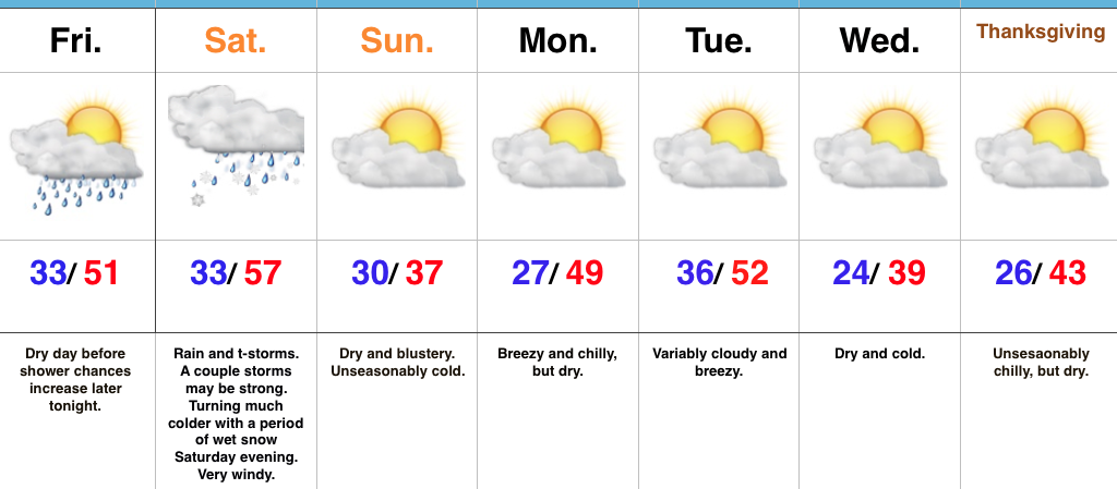
  • Big changes this weekend
  • Relatively calm Thanksgiving week
  • Chilly Thanksgiving

Storms To Snow This Weekend…An approaching storm system will lead to an active open to the weekend.  Beforehand, thankfully, we’ll close the work week out on a rather quiet note.  The daytime hours will remain dry before moisture begins to return this evening.  An initial round of showers will move across central Indiana (thinking between 8p-9p) before steadier and heavier rain and embedded thunderstorms blow into town Saturday.  A strengthening surface low will move from the central Plains tonight and into the southern Great Lakes Saturday.  This will lead to a briefly milder surge of air Saturday morning into the early afternoon before a cold front sweeps through the state and leads to a sharply colder close to the day.  Right ahead of the cold front, a skinny, but potentially intense, line of thunderstorms will track across central Indiana late Saturday morning into early Saturday afternoon.  Damaging wind gusts are possible as this thin line of storms advances across central and southern Indiana.  Winds will then shift around to the northwest and help drive much colder air into the region through the afternoon and evening.  In fact, we’ll turn cold enough to allow precipitation to end as a touch of wet snow Saturday evening.

We’ll wrap up the weekend and kick off Thanksgiving week on a much calmer note.  Chilly high pressure will build in Sunday, allowing sunshine to return, but temperatures will run around 15° below normal.  A dry cold front will pass through the state Tuesday.  With the exception of a wind shift and a few more clouds we really shouldn’t expect much more in the way of “excitement.”  This will allow unseasonably cool air to return for Thanksgiving, itself.

Upcoming 7-Day Precipitation Forecast:

  • Snowfall: Trace – Dusting
  • Rainfall: 1.00″ – 1.50″

Permanent link to this article: https://indywx.com/weekend-of-changes-storms-to-snow/

Multiple Cold Fronts Keep Us Busy…

Highlights:

  • Wet Wednesday
  • 2nd cold front Friday night
  • 3rd cold front arrives Tuesday night

Busy Weather Pattern…Rain is pressing into central Indiana this morning ahead of the first of three cold fronts we’re tracking between now and early Thanksgiving week.  Rain will be most widespread this morning into the early afternoon hours before diminishing mid to late afternoon.  Reinforcing chilly air will blow into town tonight and we’ll be in between storm systems Thursday.

Our second storm system will lead to increasing clouds Friday afternoon with showers and thunderstorms arriving overnight into Saturday morning.  Due to the slower timing of this storm, the late week severe threat has diminished significantly.  Nonetheless, it’ll be a windy afternoon and we’ll notice rising nighttime temperatures Friday as the cold front approaches.  Morning rain will continue Saturday before a sharp transition to much colder conditions with falling daytime temperatures.  We’ll kick off Thanksgiving week on a dry and cold note.

Finally, yet another cold front will approach Tuesday night.  Once this front sweeps through the state, the coldest air of the season will settle into the area just in time for Thanksgiving.

Upcoming 7-Day Precipitation Forecast:

  • Snowfall: 0.00″
  • Rainfall: 1.50″ – 1.75″

Permanent link to this article: https://indywx.com/multiple-cold-fronts-keep-us-busy/

Tracking A Couple Of Cold Fronts This Week…

Highlights:

  • Calm open to the work week
  • Two cold fronts impact the region
  • Much colder air blows in this weekend

Calm Open; Busy Close…The work week will open with weak high pressure in control of our weather.  This will result in sunshine returning along with unseasonably chilly conditions (average highs are in the mid 50s this time of year).

The first of two cold fronts will push through the state Wednesday.  Clouds will increase Tuesday evening and showers will blow into town Wednesday morning.  Breezy and chilly conditions will go along with the damp weather.

A second (stronger) cold front will impact the area to close the work week.  Strengthening low pressure will move through the Great Lakes Friday evening and help pull a briefly warmer air mass into the state.  Showers and thunderstorms will be widespread ahead of the approaching cold front and a few of these could be strong to severe.  We’ll keep a close eye on things over the next couple of days and update accordingly.  Strong and gusty southwesterly winds will reach 40 MPH+ before shifting around to the northwest once the trailing cold front sweeps through the region.  This will drive a sharply colder air mass southeast and the potential is there for lingering moisture to end as a touch of wet snow late Friday night.  The weekend will feature dry, windy, and unseasonably cold conditions.

Upcoming 7-Day Precipitation Forecast:

  • Snowfall:  Trace
  • Rainfall: 1.00″ – 1.50″

Permanent link to this article: https://indywx.com/tracking-a-couple-of-cold-fronts-this-week/

Unseasonably Cold; Weekend Ends Messy…

Highlights:

  • Filtered sunshine today
  • Raw and messy Sunday
  • Fast-moving weather pattern next week

Bundle Up…Wake up temperatures are more like we’d expect in late December as opposed to early November, including lower to middle 20s across central Indiana.  Filtered sunshine will eventually give way to a thickening cloud deck late.  Those clouds will be a harbinger of things to come as moisture overspreads the region Sunday morning.  Look for a cold, raw close to the weekend with periods of light rain (sleet may mix in with the rain during the onset early Sunday, but this won’t be a big deal).

We’ll open up the work week with dry and chilly conditions before a couple of fast-moving systems impact our mid and late week weather.  Clouds will increase Tuesday and showers will arrive at night, continuing into Wednesday.  Our next (stronger) storm will arrive to wrap up the work week.  A southwesterly air flow will inject briefly milder air Friday morning and may be sufficient enough to create a couple of thunderstorms.  We’ll then transition to a much colder, windy regime to wrap up Friday with falling temperatures.

Upcoming 7-Day Precipitation Forecast:

  • Snowfall: 0.00″
  • Rainfall: 1.00″ – 1.50″

Permanent link to this article: https://indywx.com/unseasonably-cold-weekend-ends-messy/

Sunshine Returns; Coldest Air Of The Season Awaits…

Highlights:

  • Sunshine returns
  • Coldest air of the season blows into town
  • Wet and cold close to the weekend

Coldest Air Of The Fall On Deck…High pressure is building in and will dominate our midweek weather, including sunshine and unseasonably cool temperatures.  We’ll add a gusty breeze into the mix Thursday afternoon as an early season arctic front approaches.  Once that front passes by Thursday night, a much colder air mass will plunge into the region.  If your travels take you north Friday, snowbelt regions can expect snow showers and embedded squalls as the early season arctic air helps ignite the lake effect machine.  Our first average high of 37° is on December 20th, so we’ll be running well ahead of schedule Friday.  Bundle up!

After a bright and sunny start Saturday, clouds will begin to increase during the afternoon and thicken up overnight as our next storm system approaches.  That storm system will deliver light rain Sunday.  Sunshine returns to kick off the new work week along with slightly below normal temperatures.

Upcoming 7-Day Precipitation Forecast:

  • Snowfall: 0.00″
  • Rainfall: 0.25″ – 0.50″

Permanent link to this article: https://indywx.com/sunshine-returns-coldest-air-of-the-season-awaits/