
You must be logged in to view this content. Click Here to become a member of IndyWX.com for full access. Already a member of IndyWx.com All-Access? Log-in here.
Category: Forecast
Permanent link to this article: https://indywx.com/video-pattern-evolution-into-mid-january/
Jan 01
01.01.21 Weather Bulletin: Prospects Of Accumulating Snow Increasing Tomorrow Night…
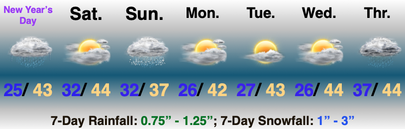
Freezing Rain Changes To Rain; Accumulating Snow Tomorrow Night? Low pressure will track into the eastern Great Lakes tonight. Temperatures will slowly rise through the day, allowing freezing rain to transition to rain. Slick roads this morning will slowly improve through the afternoon.
Attention will then shift to a trailing piece of upper level energy Saturday night and Sunday morning. While thermal profiles are marginal at best, the track and strength of the upper level energy will lead to the potential of accumulating wet snow Saturday night and Sunday morning. These are the kind of systems that can manufacture their own cold and result in “surprise” snow events for some. As things stand now, we expect a band of accumulating snow to develop across central Indiana into western Ohio tomorrow night and Sunday morning. We’ll keep a close eye on data the rest of the day and update later this evening.
Weak high pressure will nose into the region as we kick off the new work week, allowing sunshine to return.
Permanent link to this article: https://indywx.com/01-01-21-weather-bulletin-prospects-of-accumulating-snow-increasing-tomorrow-night/
Dec 30
12.30.20 Weather Bulletin: Timing Out Period Of Wet Snow By Evening; Icy Glaze To Open New Year’s Day…

Rain Ends As Wet Snow This Evening…A cold rain will continue to overspread central Indiana this morning. A cold front will slip south across the state through the afternoon and temperatures will fall into the 30s prior to sunset across most of the region. One final wave of moisture will push northeast across the area as temperatures fall into the low and mid 30s leading to a brief period of wet snow between 6p and 10p (northeast to southwest). We’re likely only looking at a window of 1-2 hours of snow at any one location, but it could fall moderate to heavy during that brief window and accumulate between a dusting and 1.5″. We’ll keep an eye on model trends through the day.
New Year’s Eve will feature dry, but gloomy and cold conditions. Look for overcast skies and highs struggling to make it to freezing.
Our second area of low pressure will lift north from the northwestern Gulf Coast into the Midwest Friday and Saturday. This will help widespread precipitation overspread the Hoosier state New Year’s Day (before sunrise for most). With cold air locked in at the surface, precipitation at the onset, continuing for a few hours north of a line from Terre Haute, Bloomington, and Cincinnati, will fall as freezing rain. If traveling early, we’d recommend caution as a light icy glaze (less than .10″ for most) is a good bet. Eventually warmer air will win out, switching things to a “plain ole rain” late morning into the afternoon.
Lingering showers will end Saturday as a trailing piece of upper level energy moves east across the Ohio Valley. Dry skies will return as we open up the new work week.
Permanent link to this article: https://indywx.com/12-30-20-weather-bulletin-timing-out-period-of-wet-snow-by-evening-icy-glaze-to-open-new-years-day/
Dec 28
12/29/20 Weather Bulletin: One More Dry Day Ahead Of An Extended Period Of Unsettled Conditions…

Enjoy The Sun While You Can…Low clouds will slowly but surely clear out of here during the overnight and early Tuesday morning. This will allow for lows to go “deep” into the 20s for most central Indiana communities Tuesday morning. Unfortunately, just as soon as skies clear, our next storm is brewing off to the west.
Clouds will increase Tuesday evening- eventually giving way to rain Wednesday. This is “part 1” of the multi-faceted storm system that’s taking aim on the region as we close out 2020. Rain will overspread the state early Wednesday (pre-dawn NW, around sunrise for immediate central IN, and early-mid afternoon across SE parts of the state). Eventually the front will settle south, placing us in the colder zone Wednesday night and Thursday morning. With the colder air will also come a period of drier conditions. By this point low pressure will begin to organize along the NW Gulf Coast before lifting north. As this takes place, the same frontal boundary that settles south of our region will lift back north as a warm front New Year’s Day. Rain (potentially heavy at times) will accompany this event, continuing into early Saturday. (The bulk of our 7-day forecast rainfall amounts will fall New Year’s Day, itself). Overall, model consensus is warmer today than the past couple of days, but we’ll keep a close eye on things.
Colder, drier air will filter back into the region next weekend…
Permanent link to this article: https://indywx.com/12-29-20-weather-bulletin-one-more-dry-day-ahead-of-an-extended-period-of-unsettled-conditions/
Dec 27
12/28/20 Weather Bulletin: Dry, Chilly Weather Monday-Tuesday; Questions Abound With Our NYE Storm…

Pre-Dawn High; Sunshine Returns…Our high temperature Monday will take place right after midnight for most of central Indiana. Daytime temperatures will remain steady in the low-mid 30s for most of the region as clouds slowly give way to a return of the sunshine. This is all thanks to a cold front that slipped southeast across the state last night. (Same boundary that helped generate some light showers across the region Sunday evening).
High pressure will continue to dominate our area Tuesday, but “trouble” lurks off to the west. Clouds will begin to increase during the 2nd half of the day and a few light showers (potentially mixed with snow across northern parts of the state) will arrive on the scene late in the evening as a warm front lifts north.
Midweek will feature unsettled weather conditions, but there are more questions than answers currently and fine tuning will take place over the next 24-48 hours. Solutions currently range from mild/ wet to a mixed bag, including ice and snow. In short, stay tuned… The one constant that remains is that this will be a more significant storm for central and western portions of the OHV than our Christmas Eve event. That said, details pertaining to precipitation type/ amounts are anyone’s guess from this point.
Chilly, dry conditions will return by the weekend.
Permanent link to this article: https://indywx.com/12-28-20-weather-bulletin-dry-chilly-weather-monday-tuesday-questions-abound-with-our-nye-storm/