Category: Forecast

Frigid Times; Moderating This Weekend…

Highlights:

  • Dangerously cold
  • Dry times return
  • Moderating this weekend

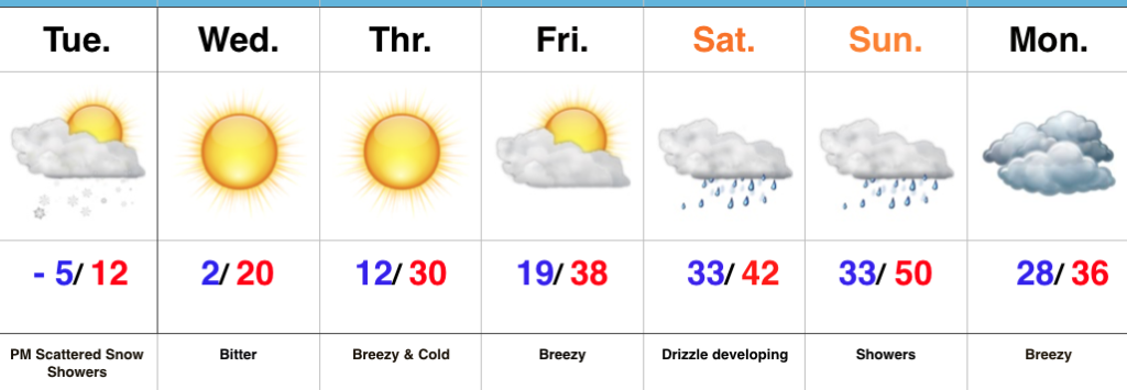
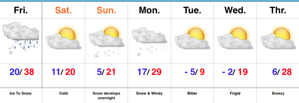
Bitter, Bitter…Arctic high pressure will dominate our weather through the early and mid week stretch.  We note high resolution modeling trying to swing a couple bands of light lake effect snow through north-central Indiana later this afternoon and evening and we’ll continue to keep snow showers in our forecast for this reason.  Otherwise, cold is the story today.  We’re starting our Tuesday adding yet another sub-zero low to the already impressive list this winter.  Cold continues Wednesday before beginning to turn “less cold” through late week.

Our next storm system will approach this weekend.  As low pressure tracks into the Great Lakes, a milder southwesterly flow will allow temperatures to zoom all the way up close to 50° by Sunday.  Fog and drizzle will develop Saturday before “showery” and breezy conditions build in ahead of the front Sunday.

Upcoming 7-Day Precipitation Forecast:

  • Snowfall:  Dusting
  • Rainfall: 0.40″ to 0.50″

Permanent link to this article: https://indywx.com/frigid-times-moderating-this-weekend/

Monday Morning Notes…

Bursts of moderate to heavy snow will work across the metro during the next couple hours. This will lead to significant drops in visibility and serve to mess up roadways even more than they currently are. If you don’t have to travel through the morning hours we recommend staying home and allowing road crews time to get things cleaned up.

Most of the steady accumulating snow will be over with by late morning and we’ll just be left with scattered snow showers through the afternoon hours. Perhaps the bigger story by then will be significant blowing and drifting snow as gusty westerly winds help usher in colder air. If your travels include country roads, or north-south oriented highways, plan on considerable blowing and drifting snow this afternoon and evening.

We have no changes to our going snowfall forecast with this system.

Finally, as the arctic front sweeps through the state this afternoon, it’ll likely kick up some intense, blinding snow bursts.  While these won’t last long, they’ll blast through during the evening rush and will serve to dramatically lower visibility.  We note high resolution models are picking up on these snow bursts on forecast radar products.

We’re left tonight with bitterly cold conditions that will continue to grip the region through midweek. Most of us Tuesday morning will be below zero. A moderating trend will develop by late week, continuing through the weekend!
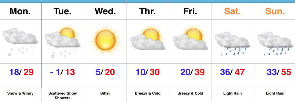
Permanent link to this article: https://indywx.com/monday-morning-notes/

Gas Up The Plows; Arctic Air Returns…

Highlights:

  • Heavy snow Monday morning
  • Bitter air returns
  • Milder, wet weekend

Snowy Open To The Week…A vigorous clipper system and associated arctic cold front will drop southeast and spread a swath of snow across the region tonight into Monday.  We expect light snow to encompass most of central Indiana later this evening (between 7p and 10p west to east) before increasing in overall intensity during the overnight.  Periods of moderate to heavy snow can be expected during the mid-morning hours Monday, including impressive snowfall rates at times.  Allow plenty of extra time to reach your destination Monday.  Steady snow will give way to scattered snow showers during the afternoon, continuing into Tuesday as fresh arctic air pours into the region.  By the time all is said and done, most of the region can expect a fresh 2″ to 4″, including some locally heavier totals.  The other item on the agenda will be blowing and drifting snow that we’ll have to deal with Monday afternoon through the night and into Tuesday.

Arctic high pressure will settle overhead Tuesday night through the midweek stretch, allowing sunshine to return, but we’ll remain well below average (average temperatures this time of year include highs in the mid-30s and lows around 20).

A moderating trend takes place late week, but the “less cold” air will come with gusty southwesterly winds and increasing clouds Friday.  Those clouds will give way to periods of rain along with milder conditions over the weekend as an area of low pressure tracks into the Great Lakes.

Upcoming 7-Day Precipitation Forecast:

  • Snowfall: 2″ to 4″ (locally heavier totals)
  • Rainfall: 0.25″ to 0.75″

Permanent link to this article: https://indywx.com/gas-up-the-plows-arctic-air-returns/

Another “Plowable” Snow Gives Way To Sub-Zero Cold…

With the exception of light lake effect snow showers today (noticing a couple of light bands just west of the city as we write this Saturday morning around 10a), most of today and Sunday will be dry and cold.  We’ll top out around 20° today and Sunday with low temperatures tonight dropping into the 0° to 5° range.

Our next snow maker will arrive late Sunday night into Monday morning in the form of a clipper system.

Forecast radar 1a Monday.

We expect light snow Monday morning to grow in overall coverage and intensity through the late morning and into the early afternoon hours.

Forecast radar 10a Monday.

Accumulating snow will push off to the south Monday evening.

Forecast radar 7p Monday.

This will be a plowable event for central Indiana and we’ll also have to deal with blowing and drifting concerns Monday afternoon through Monday night as strong and gusty northwest winds arrive.  Needless to say, to our snow removal and DPW crews out there, find a way to get some rest this afternoon and Sunday before another busy stretch to open the work week.  We think additional snowfall of 2″ to 4″ is a good bet across the northern half of the state, with slightly lighter amounts of 1″ to 2″ across southern Indiana.

Arctic high pressure will settle over a growing snowpack to help setup a frigid stretch through early and mid week.  Multiple nights with below zero readings are expected beginning Tuesday morning where most will wake up to readings of 3° to 8° below zero (not counting the wind chill).

Permanent link to this article: https://indywx.com/another-plowable-snow-gives-way-to-sub-zero-cold/

Wintry Forecast; New “Plowable” Snow Event Arrives Monday…

Highlights:

  • Sleet changes to snow
  • New snow and wind maker Monday
  • Bitter air returns

Double Shot Of Impactful Winter Weather…A mixture of sleet and freezing rain will begin to transition to snow from west to east as we progress through the late morning into the early afternoon.  We don’t have any significant changes to our snowfall forecast (remember this doesn’t include the freezing rain and sleet accumulations that have led to travel issues this morning already).  Embedded snow bands will likely result in enhanced snowfall rates into the early afternoon across central Indiana.

Precipitation will end for all except southeastern portions of the state by mid-to-late afternoon and then we’re left with the “clean up” from round one.  Saturday and most of Sunday will feature dry and very cold conditions.

Our attention this weekend will then shift to a potent clipper system that has eyes on central Indiana late Sunday night into Monday.  Snow will overspread the region during this timeframe and given the nature of this event, heavier, more intense snow bursts are also expected to accompany the fresh arctic air that will drill in here Monday evening.  This will be an impactful event not only from the new falling snow, but from problems that wind and drifting will bring, along with a new batch of sub-zero temperatures.  Our snowfall forecast Monday hasn’t changed since yesterday, including widespread additional amounts of 2″ to 4″.

Dry, but bitterly cold conditions return for the mid and late week stretch.

Upcoming 7-Day Precipitation Forecast:

  • Snowfall: 3″ to 6″
  • Rainfall: 0.00″

*Please note the 7-day precipitation forecast outlined above is for Indianapolis proper.

Permanent link to this article: https://indywx.com/wintry-forecast-new-plowable-snow-event-arrives-monday/