Category: Forecast

Snowy Evening Ahead…

We’re still on track for accumulating snow arriving into central Indiana this afternoon and continuing through the evening. Expect the rush hour to be impacted. Snow will overspread central Indiana…

You must be logged in to view this content. Click Here to become a member of IndyWX.com for full access.  Already a member of IndyWx.com All-Access?  Log-in here.

Permanent link to this article: https://indywx.com/snowy-evening-ahead/

Video Update On Wednesday’s Snow…

Quick video update this evening talking about the snow, wind, and bitterly cold air that blows into town Wednesday.  Plan on a nasty evening commute tomorrow, friends.

You must be logged in to view this content. Click Here to become a member of IndyWX.com for full access.  Already a member of IndyWx.com All-Access?  Log-in here.

Permanent link to this article: https://indywx.com/video-update-on-wednesdays-snow/

Decent Day Today; Snowy Wednesday Afternoon Ahead

Screen Shot 2015-02-03 at 8.02.05 AMNot A Bad Day Today; Snow Event Wednesday…After a cold start today, temperatures will moderate into the lower to middle 30s this afternoon.  We’ll be in a weak southerly air flow this afternoon as a disturbance tracks to our north.

The big focus of this forecast package has to do with Wednesday. We forecast a quiet start to the day, but clouds will quickly lower and thicken and widespread snow, briefly heavy, will overspread all of the region tomorrow afternoon.  This will be a dry, powdery snow as all of the snow will fall behind an arctic boundary that will slip through the region.  As of now we forecast 2″-3″ of snow tomorrow afternoon into tomorrow evening.  Strong and gusty north winds will lead to blowing and drifting issues Wednesday evening.  All in all, expect the Wednesday evening rush to be impacted.  Frigid air will settle over the region by Thursday morning with dry conditions returning.

Temperatures will slowly moderate briefly out ahead of our next weekend weather maker.  Keep an eye on Sunday-Monday as that will be our next opportunity for accumulating wintry precipitation.

Upcoming 7-Day Precipitation Forecast:

  • 7-Day Snowfall Forecast: 2″ – 4″
  • 7-Day Rainfall Forecast: 0.10″

Permanent link to this article: https://indywx.com/decent-day-today-snowy-wednesday-afternoon-ahead/

Cold Start To The Work Week; Watching Wednesday…

Screen Shot 2015-02-02 at 7.46.45 AMBundle Up…Snow showers and gusty winds are combining with refreezing of snow and moisture on roadways to create slick travel this Monday morning.  Leave extra time on your way to work and school this morning and travel safely.  Additionally, gusty northwest winds are pushing wind chill values into the subzero ranks.  As we progress through the day we should see increasing sunshine, but it’ll remain frigid.

Our next storm system of interest arrives by the middle of the week.  Forecast models differ on the timing and amount of moisture with this next storm, but there’s the chance of accumulating snow arriving Wednesday.  This would be in advance of a quick-hitting pop of arctic air.  We’ll keep a close eye on things.

The active pattern remains into the upcoming weekend as increasing clouds give way to showers Saturday and a transition to more a of wintry mix Sunday.

Upcoming 7-Day Precipitation Forecast:

  • 7-Day Snowfall Forecast: 1″ – 2″
  • 7-Day Rainfall Forecast: 0.10″ – 0.20″

Permanent link to this article: https://indywx.com/cold-start-to-the-work-week-watching-wednesday/

Period Of Snow Moving In…

As mentioned below, bust potential was/ is high with today’s forecast.  The further north trends in the NAM and GFS will ultimately trump the normally reliable Canadian and European solutions.  As such, slushy snowfall accumulations will be light (1″-2″) for the city, itself, increasing to between 2″-5″ for northern Indianapolis suburbs (Zionsville, Carmel, Westfield, Noblesville, etc.).  Double digit totals will fall across the northern third of the state.

For the most part, snowfall accumulations will come from this area of precipitation moving through the region.

Screen Shot 2015-02-01 at 9.30.06 AM


Heavy wet snow will likely fall for a period of time, especially from northern portions of Indianapolis and points north late morning into the early afternoon.

hires_ref_indy_6


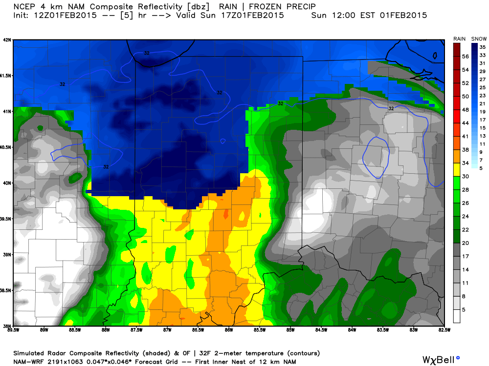
Temperatures will then likely creep up a few degrees through the mid afternoon hours before falling this evening.  Snow will mix with, or change to, snow across central regions this afternoon with the northward track of the low.  Note the stark temperature contrast across the region this evening.

hrrr_t2m_indy_16


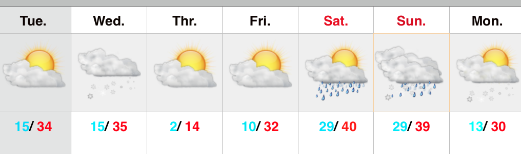
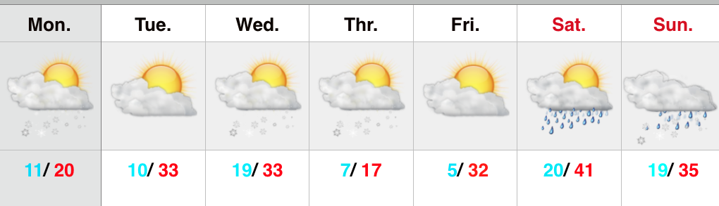
The week will get off to a cold start as highs Monday only top out in the lower 20s.  Enjoy your Super Bowl Sunday and keep the reports coming!

Permanent link to this article: https://indywx.com/period-of-snow-moving-in/