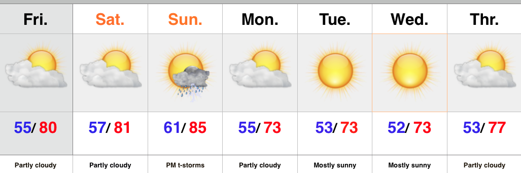
Category: Forecast
Highlights:
- MUCH cooler than normal, fall feel blows into town
- Dry week ahead
- Moisture and warmth returns for the weekend
A cold front is on the doorstep this evening and will sweep through the region tonight. Ahead of the front we’ll maintain mention of a shower or thunderstorm, but the band of storms coming through will be “broken” and everyone won’t get wet. A MUCH cooler feel will blow into town tonight and remain intact through the balance of the work week ahead- a downright fall feel. Winds will be breezy Monday afternoon out of the northwest.
Moisture and warmth will return as we head into the upcoming weekend along with an isolated to widely scattered thunderstorm chance.
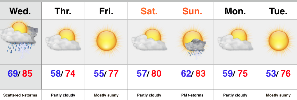
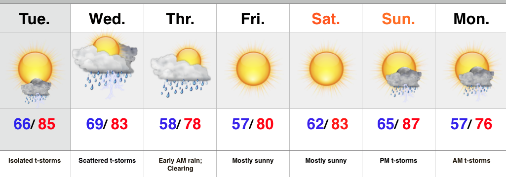
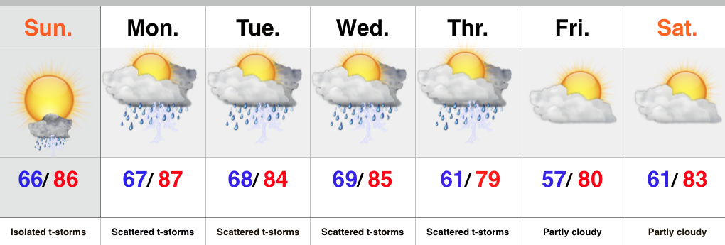
Upcoming 7-Day Rainfall Forecast: 0.10″ – 0.25″
Tonight’s “@cryptics Cam” captures storm clouds gathering to the west as a cold front moves into town. This image was snapped around 4:15p Sunday evening.
Permanent link to this article: https://indywx.com/fall-feel-arrives-tonight/
Highlights:
- Very nice close to the week
- Sunday storm potential
- Another blast of fall-like air to open the week
High pressure will remain in control of our weather to wrap up the week. As a result look for lots of sunshine and dry air to continue. The next couple mornings will get off to an unseasonably cool start, but the late August sun will help us warm quickly to around 80 today and Saturday. Enough southwesterly flow will be in place Sunday to bump temperatures and moisture levels a “touch.” As a cold front slides into the area we’ll add scattered to numerous thunderstorms into the picture Sunday afternoon and evening. Forecast models vary considerably on rainfall totals, including not much more than one tenth of an inch from the GFS to around an inch with the European. The 12z Canadian is very aggressive suggesting a swath of 2″ through central IN. We’ll discard that solution for now and side with a blend between the GFS and European.
The big story next week is another push of well below normal, unseasonably cool, air! If you aren’t craving fall now then you’re certain to by early next week! (Ah, we’re so close to football season I can hardly stand it).
Upcoming 7-Day Rainfall Forecast: 0.50″ – 1″
Talk about a gorgeous day and an even better sunset! Tonight’s “@cryptics Cam” captures that sunset in crisp, clear fashion. Be sure to follow @cryptics on Twitter for awesome views of the sky and associated weather conditions here across central IN!
Permanent link to this article: https://indywx.com/weekend-moderation-before-another-push-of-fall-like-air/
Highlights:
- Strong to severe storm potential Wednesday
- Much cooler to end the week
- Second cold front delivers storms Sunday and cooler air
Tuesday featured mostly dry conditions across the majority of central IN, but the same likely won’t be said for Wednesday. A cold front will swing through the region Wednesday night and in advance of the front scattered strong to severe thunderstorms will be possible, especially Wednesday afternoon/ evening. Damaging wind is the biggest severe threat. The reasoning behind the turbulent Wednesday weather? A strong cold front that will sweep through the area and deliver much drier and cooler air to finish the work week.
While the weekend will get off to a quiet open, another cold front will deliver scattered thunderstorms by Sunday afternoon and evening. Behind the front we can expect much cooler, fall-like air to open the new work week.
Upcoming 7-Day Rainfall Forecast: 1″ – 1.5″
Tonight’s “@cryptics Cam” shows a very nice time lapse of the foggy start and afternoon sunshine in Danville today. Be sure to follow @cryptics on Twitter for awesome views of the sky and associated weather conditions here across central IN!

Permanent link to this article: https://indywx.com/tracking-two-cold-fronts/
Highlights:
- Strong to severe storm potential Wednesday
- Cooler Thursday
- Nice close to the week
- Another cold front delivers late storms Sunday then another pop of cool air
Monday afternoon turned wet across central IN as a disturbance lifted north across the state, including Gulf of Mexico moisture. Localized strong storms and torrential rainfall impacted many neighborhoods.
Coverage of showers and storms will be much less Tuesday, but we still will maintain an isolated storm as a possibility.
Attention will then shift to two cold fronts that will impact the region between mid week and early next week. Strong to severe storms are possible Wednesday afternoon and evening followed by much cooler air moving in for Thursday. We’ll keep a close eye on things. After nice weather Thursday through Saturday, another cold front will swing into the Hoosier state Sunday night/ early Monday with another round of showers and thunderstorms. Yet another pop of unseasonably cool air will follow to open next week.
Upcoming 7-Day Rainfall Forecast: 1″ – 1.5″ (locally heavier totals)
Tonight’s “@cryptics Cam” shows a very nice time lapse of storms as they blew through Danville earlier today. Be sure to follow @cryptics on Twitter for awesome views of the sky and associated weather conditions here across central IN!

Permanent link to this article: https://indywx.com/wednesday-storms-then-cooler/
Highlights:
- Warm and humid
- Midweek storms may reach strong to severe levels
- Late week model differences
The second half of the weekend will feature plenty of warmth and humidity, but should be mainly dry. We’ll include mention of an isolated storm. Better coverage of showers and thunderstorms will return to our forecast through the early week period and we’ll continue to keep a close eye on the potential of strong to severe thunderstorms Wednesday into Thursday. Stay tuned.
As we look forward, there’s some disagreement with the evolution of things from mid to late week. The GFS is more progressive and delivers drier, cooler air to wrap up the week, while the European is a bit more sluggish. We’ll go with a blend for now, leaning more towards the GFS solution.
Upcoming 7-Day Rainfall Forecast: 1″ – 1.5″
Permanent link to this article: https://indywx.com/keeping-an-eye-on-mid-week-storms/