Category: Forecast

Winds Of Change…

Screen Shot 2015-10-10 at 5.09.58 PMHighlights:

  • Mostly dry theme continues
  • Get used to the term “breezy!”
  • Much cooler air coming

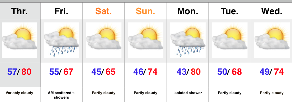
We couldn’t have asked for better weather for a Saturday and, thankfully, we’ll experience a repeat tomorrow (tack on a few degrees for afternoon highs).  Breezy SW winds (gusts upwards of 30 MPH) will kick temperatures up to near 80 Monday afternoon before a cold front sweeps through the region Monday night.  While an isolated shower is possible Monday, most of central IN will remain rain-free.  Cooler air will arrive Tuesday and Wednesday.

A stronger cold front will move into the region Friday.  Like our early week front, this one, too, will be moisture-starved.  Windy conditions and MUCH cooler air will be the big deal going into next weekend.  Most communities will experience their first frost Saturday and/ or Sunday morning.

Upcoming 7-Day Rainfall Forecast: Trace to 0.10″

Permanent link to this article: https://indywx.com/winds-of-change/

Warm Thursday With A Cooler Open To The Weekend…

Screen Shot 2015-10-07 at 9.53.16 PMHighlights:

  • Warm Thursday
  • Cold front swings through Friday
  • Great fall weekend coming

Thursday will feature another round of morning fog across central IN, but should be less widespread than the previous couple mornings.  A southwest wind ahead of an approaching cold front will help boost temperatures up close to 80 this afternoon.  As the front moves in Friday a broken band of showers and embedded thunder will accompany it.  We’re not talking a lot of rain Friday, and the cooler air will be the bigger deal as we wrap up the work week and head into the weekend.

Another front will swing through the area Monday afternoon and evening.  Ah, the “ups and downs” of fall will remain prevalent throughout the upcoming seven days…

Upcoming 7-Day Rainfall Forecast: 0.10″

Permanent link to this article: https://indywx.com/warm-thursday-with-a-cooler-open-to-the-weekend/

Pleasant Stretch Continues For Now…

Screen Shot 2015-10-05 at 10.10.52 PMHighlights:

  • Dry, warm days continue
  • Friday cold front
  • Ups and downs of fall

Some mid and high level cloudiness will drift across the Mid West today and a sprinkle or two is possible, but filtered sunshine can also be expected after AM fog burns off.  We’ll return to warm, sunny days and clear, cool nights tomorrow and Thursday and this will combine with the unseasonable chill of last weekend to continue putting the color change into high gear across central IN.  BTW- the upcoming weekend should be fantastic for an autumn drive to take in the fall foliage.

A cold front will approach the region late Thursday and we bracket Thursday evening into Friday morning for the chance of scattered showers and thunderstorms.  Cooler air will filter into the area as we head into the weekend.

The “ups and downs” of fall will continue next week as warmth arrives early in the week before cooler chances once again prevail later in the week….

Upcoming 7-Day Rainfall Forecast: 0.10″ – 0.25″

Permanent link to this article: https://indywx.com/pleasant-stretch-continues-for-now/

Cold, Raw Saturday; Sunday Rebound…

Screen Shot 2015-10-02 at 10.24.21 PMHighlights:

  • Windy, wet, and cold Saturday
  • Much better Sunday
  • Pleasant week upcoming

A widespread area of light to moderate rain encompasses central IN as we type this.  It’s a chilly night across the region with temperatures around 50 and northeast winds gusting over 30 MPH.    Unfortunately, we don’t have better news Saturday as winds remain strong and gusty and another push of moisture arrives from the east Saturday afternoon.  Rain amounts won’t be significant, but serve as a great big nuisance when you factor in all of the elements (rain, wind, and unseasonably cool air).  Jackets, coats, and sweaters will be required Saturday.

Thankfully, we’ll salvage a much better second half of the weekend as drier (and warmer) air arrives on the scene.  The other bit of good news?  Significantly diminished winds.

Much of the upcoming work week will provide dry and pleasant weather across the area- perfect for #Harvest15!  Enjoy!

Upcoming 7-Day Rainfall Forecast: 0.10-0.25″

Permanent link to this article: https://indywx.com/cold-raw-saturday-sunday-rebound/

Wind And Cool Air The Big Story Here…

Screen Shot 2015-10-01 at 10.22.27 PMHighlights:

  • Clouds and wind increases Friday
  • Windy, chilly, showery Saturday
  • Brighter days ahead with warmer temperatures

Hurricane Joaquin remains at the top of many weather headlines, and rightfully so.  Currently a category 4 hurricane, Joaquin is nearly stationary in the Bahamas this evening and presenting problems on many fronts (storm surge, wind, flooding).  Eventually Joaquin will make a northward turn and begin to pick up momentum Friday night and Saturday.  Today’s model guidance remains firm on the idea Joaquin will remain off shore from the US mainland, but we’ll need to continue to keep a close eye on things.

Here on the home front, the combination of the high to our northeast and upper low across the southeast will really serve to tighten the pressure gradient and result in strong east and northeast winds as we wrap up the work week and head into the weekend.  Gusts of 30-40 MPH will be a good bet.

Clouds will be on the increase Friday with the possibility of PM showers- particularly east and southeast.  It’ll be a cool day, but nothing compared to Saturday.  Expect better coverage of showers Saturday, continued gusty winds, and even cooler air.

Brighter (and warmer) times will begin to return to wrap up the weekend and head into next week.

Upcoming 7-day Rainfall Forecast: 0.10″ (NW) – 0.50″ (SE)

Permanent link to this article: https://indywx.com/wind-and-cool-air-the-big-story-here/