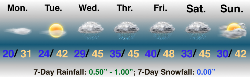
A couple of storm systems will impact the region between Wednesday and the weekend, but neither look particularly impressive. What does look a little more “interesting” is the pattern evolution as we get closer to Christmas… Video discussion and updated 7-day below!
Slow It Down…Freezing fog is creating slick travel in and around the city, itself, and points north. Please allow extra time to reach your destination this morning and take it slow. As we move into the afternoon, the low clouds and fog should slowly lift, but it’s likely not until we get to mid to late afternoon. With the longer period of fog and clouds, we’ve dropped forecast highs a few degrees today.
We should still get in on a sunny Tuesday before our first of a series of storm system begin to impact the area Wednesday. Weak low pressure will result in increasing clouds and a narrow band of showers Wednesday afternoon. Rain may mix with snow across north-central parts of the state.
As we look ahead, a slow moving (bigger) storm system spells periods of wet weather as we close the week and head into the weekend. While it won’t rain the entire time, periods of moderate to heavy rain are possible during the period, along with gusty winds, and an overall “raw” feel. Early thinking here is that we salvage the 2nd half of the weekend with at least a touch of sun.
Needed Vitamin D…It’s not often that we can string up consecutive sunny days in early and mid December, but that’s exactly what we’ll do this week- and we won’t complain! With the clear, calm conditions, overnight lows will continue to plummet into the 10s before we slowly begin to moderate as we move into the middle of the week.
With the moderating temperatures will also come increasing moisture as a new storm system organizes to our southwest Wednesday night and Thursday. Models continue to differ on specifics with respect to rainfall totals and we’ll fine tune things as we progress through the next couple of days. While late week turns unsettled, we don’t expect a wash-out any day.
Looking ahead, the longer term models continue to suggest we’re going to pull out of the predominantly cold pattern that we’ve been in with an overall milder shift in the pattern for the next couple of weeks. There’s much debate around when the flip back to a cold pattern returns- is it in time for Christmas or closer to the New Year?
Bundle Up…“Number-busting” cold has settled into many Mid West communities this morning as just enough snow cover combined with clearing overnight skies. The result is a 5º to as much as a 10º difference in actual low temperatures this morning when compared to the majority of guidance yesterday. Bundle up, as many across central Indiana are waking up to temperatures in the upper single digits to middle 10s. Thankfully, dry conditions are expected not only today, but straight through the weekend and on into early next week- along with plentiful sunshine!
Temperatures will gradually turn “less cold” early next week and we’re eyeing our next storm system for a Wednesday night to Thursday arrival.
Messy Afternoon Commute For Some…The day is starting quiet, but a fast moving arctic cold front will push through the state this afternoon. Ahead of the boundary, an expanding area of precipitation will break out late morning into the early afternoon hours. From the city and points north, most of this should fall as wet snow. South of the city, a mixture of rain and snow is expected. A quick 1″ of snow is likely for areas north of Indianapolis and as temperatures fall this afternoon and evening, a slick evening commute is possible. Allow yourself extra time.
Cold air will reinforce itself behind the front tonight and through the weekend, BUT sunshine will return! All eyes will be off to our south as a major winter storm impacts our friends across the TN Valley into the Southern Appalachians. If you’re one of our viewers from the east TN/ western NC mountains, get to the grocery store today and plan to hunker down. You’ll need the yardstick to measure this one when all is said and done Monday night…


 Highlights:
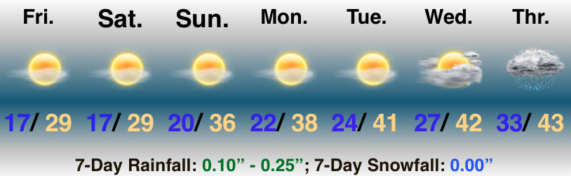 Highlights:
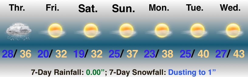 Highlights: