Tuesday Evening Video Update!

Good evening and thank you for logging onto IndyWx.com!  Tonight’s video covers the unsettled time of things tonight into Wednesday morning as low pressure continues to have a hold on our area’s weather.  Also, we talk long range weather and give you an idea of what you can expect for the rest of the month of June, temperature-wise!  While we didn’t get into the precipitation side of things in tonight’s video for late month, I will say it continues to look very unsettled with above average rainfall anticipated to wrap up the month of June.  Anywhere from an additional 3-5″ of rain is possible as we go through the rest of the month here across central Indiana.

While the CFSv2 can be a bit erratic at times, we feel the model has a good handle on the way the overall pattern will evolve late June into July.

Soaking Rain Ahead Tuesday Into Wednesday.

We still think most of today is dry and while we’re off to a cloudy start, the latest scan of the visible satellite image would suggest some brightening of the sky is a good bet from time to time late morning into the afternoon.

20140609_1145_sm_EVV_vis

Enjoy whatever sunshine you see today, as clouds begin to lower and thicken this evening and widespread rain won’t be far behind.  The simulated radar shows rain and embedded thunder will be rather widespread Tuesday.

6am Tuesday future radar product
11a Tuesday future radar product
2a Wednesday future radar product

Widespread rainfall totals of 1-2″ will be a good bet between Tuesday and Wednesday and we feel the short-term, high resolution, NAM forecast model has a good handle on the distribution of precipitation.  There will be locally heavier totals.

hires_t_precip_ky_20

We’ll have your complete 7-day forecast updated and posted later this evening!

Unsettled Stretch Ahead…

Sun.

Mon.

Tue.

Wed.

Thr.

Fri.

Sat.

 Status-weather-showers-day-icon

 Status-weather-clouds-icon

 Status-weather-storm-night-icon

 Status-weather-showers-day-icon

 Status-weather-showers-day-icon

 Status-weather-showers-day-icon

 Status-weather-clouds-icon

59/ 75

55/ 77

62/ 75

66/ 76

66/ 77

61/ 75

55/ 78 

Light

– – –

Light

Light

Light

Light

– – –

Showers and thunderstorms will rumble into central Indiana during the overnight hours.  While some short term forecast models suggest some hefty rainfall totals, we think what’s more than likely to happen is that most neighborhoods see around one half inch late tonight into the wee morning hours Sunday.  There will be some locally heavier totals reported closer to 1″, but that will be the exception to the rule!  The local air mass is just so dry (as of this evening dew points are still in the lower 50s across central Indiana) and while moisture will increase through the night, it’ll likely be too little too late.  Regardless, don’t be surprised if a rumble of thunder wakes you during the overnight. Some early showers are possible Sunday, otherwise the theme will be a drier one through the day.  While some of our short-term forecast models suggest showers are around Monday, we’re siding more with the GFS and European models and providing a dry start to the work week (we’ll continue to monitor and update if needed Sunday).

The rest of the work week will feature a busy time of things in the good ole forecast office as we track multiple disturbances.  Each one of these will be capable of producing heavy rain and embedded thunderstorms.  As of now, we’re forecasting heavier rain Tuesday and Friday, but we’ll fine tune the timing as we move forward.

Finally, as we move into next weekend, there are considerable model difference between the GFS and European forecast model.  For now, we’re splitting it down the middle and going with dry skies along with comfortable temperatures Saturday.  Model numbers vary from the upper 40s (GFS) to middle 50s (EC) for overnight lows and lower 70s (GFS) to middle 80s (EC).

More later, friends!  Have a relaxing evening!

Battle Developing Mid/ Late June

As we progress into another weekend, weather conditions simply couldn’t be any better for this time of year.  The back half of the weekend will transition to one that’s more unsettled and feature showers and thunderstorms for Sunday.  Modeling today is backing off on the heavy rain event Sunday and hitting another system coming through the pipeline Tuesday into Wednesday with heavy rain.  We’ll keep an eye on things and update our forecast Friday morning.  Regardless, let us worry about Sunday and you be sure to enjoy Friday and Saturday!

The pool of cool will keep things feeling might nice through the first half of the weekend, along with low humidity and plenty of sunshine!
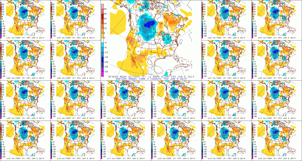
D1

As we look into the long range, there are some questions that arise.  The questions don’t have to do with warming that’s likely to take place late week 2 (90s within reach), but just how long that ridge and associated dome of heat hangs around.  The European ensembles would imply the bubbling heat ridge will stick around for a few days.
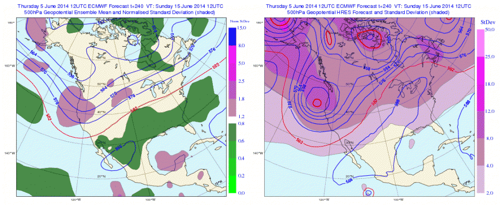
Geopotential32at32500hPa_North32America_240

Meanwhile, it should be noted that the European weeklies disagree with its own ensemble package as they bring a cooler pattern and associated trough back into the Great Lakes and northeast region as we get set to head into the last week of June.  Due to licensing issues we can’t show the European weeklies here, but they deliver quite the trough and cooler than normal air mass around, or just after, the 23rd.

Additionally, the PSD agrees and delivers a cool pattern around June 20th.

z500_anom_f360_ussm


So, while we’re likely to see the hottest weather of the season so far towards Day 10, confidence of this hot weather sticking and holding is very low.  Timing will have to be resolved as it always does in long range weather.  Overall, what’s more likely to happen is that this will be a transient hot pattern and we flip the script to one that’s cooler than average as we go into the last week of the month.

Wednesday Evening Video Update; Drier, Cooler Air Coming!

Good evening, friends.  Here’s a video update as we get set to welcome a cooler, drier regime into central Indiana to wrap up the work week.  Additionally, we’re also tracking another potential heavy rain maker for the second half of the weekend (not that we need more heavy rain)….

PS: The IndyWx.com mascots have attempted more times than not to interrupt my video updates, so I only thought it was time to give them a little face time.  Meet Cameron (left) and Newton (right).

10389646_756078747757579_4757052835498909820_n