Still Focused On This Evening For Severe Storm Potential.

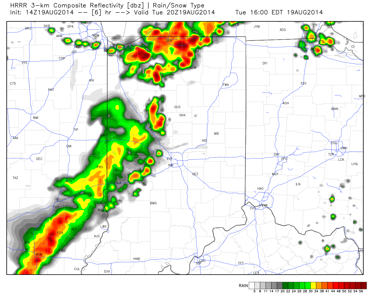
A look at some of the latest data hot off the press suggests we remain under fire for the potential of scattered strong to severe thunderstorms late afternoon into the evening hours.  Initial activity could fire as early as 3-4 o’clock across western sections.  The latest HRRR forecast radar (valid at 4pm) shows an advancing line of strong, and possibly severe, storms pushing east.
hrrr_ref_indy_7

Again, the primary threat is damaging wind, but a couple hail reports will also be possible.

As of the 12 o’clock hour, a complex of thunderstorms sits to our west across western/ central portions of Illinois.  We’ll keep a close eye on this complex as it continues pushing east and likely intensifies in a hot, humid, and unstable air mass over the next few hours.  Please plan a way to keep abreast of the latest radar and local media this afternoon and evening as storms move in.

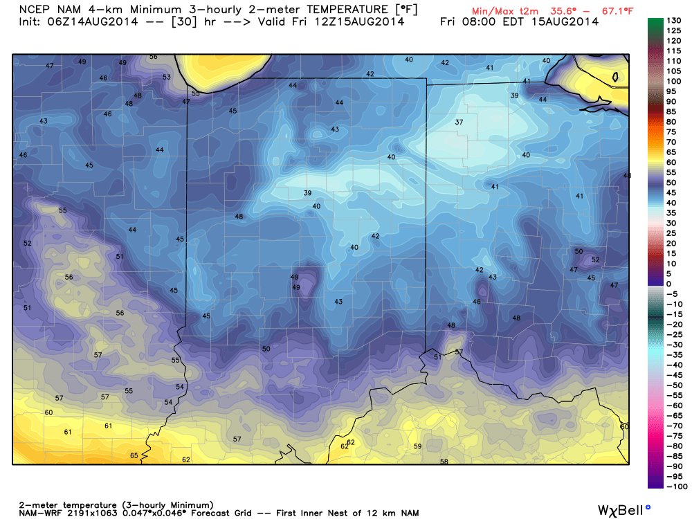
Throw An Extra Blanket On The Bed Tonight…

Thr.

Fri.

Sat.

Sun.

Mon.

Tue.

Wed.

 Status-weather-clouds-icon

 Status-weather-clouds-icon

 Status-weather-showers-day-icon

 Status-weather-showers-day-icon

 Status-weather-showers-day-icon

 Status-weather-showers-day-icon

 Status-weather-showers-day-icon

55/ 78

48/ 76

56/ 81

64/ 83

69/ 81

70/ 81

67/ 85 

Reinforcing Cool Air Blowing In…A reinforcing push of cool air is blowing into town today and will result in a downright chilly night ahead (especially considering the time of year).  A couple showers can still be expected across south-central parts of the state, but won’t amount to much.  The big news will be the chilly temperatures tonight as we forecast upper 40s officially in the city and low to mid 40s across northeastern suburbs.  Highs will only climb into the middle 70s with lots of sunshine Friday.

Warmer And More Unsettled…Temperatures will moderate into the weekend, but we’re also going to introduce rain chances back into the picture.  Most of Saturday will remain rain-free, but we can’t rule out scattered showers and thunderstorms as the first in a series of disturbances tries to overcome initial dry air in place.  Better rain and storm chances will prevail Sunday.

Heavy Rain Next Week…Forecast rainfall numbers continue to rise next week as a series of weather makers impacts central Indiana.  A good consensus would place 1.5″ to 2″ of rain down, with locally heavier totals.  Stay tuned as we fine tune timing.

7-Day Precipitation Outlook:

  • 7-Day Rainfall Forecast: 1.5″-2″
  • 7-Day Snowfall Forecast: 0.00″

We’re enjoying another colorful sunrise across central Indiana this morning.  John Salewicz snapped this scenic photo earlier this morning.  Thanks, John!

en9WWAwc

Throw an extra blanket on the bed tonight!  Temperatures will dip into the mid to upper 40s for many.
Throw an extra blanket on the bed tonight! Temperatures will dip into the mid to upper 40s for many.

Cool Close To The Work Week; Longer Range Talk…

Clouds will increase this evening and an isolated shower is possible though most will remain dry.  More on this and a look ahead to the weekend and beyond in the…

You must be logged in to view this content. Click Here to become a member of IndyWX.com for full access.  Already a member of IndyWx.com All-Access?  Log-in here.

Shower Chance This Evening…

Wed.

Thr.

Fri.

Sat.

Sun.

Mon.

Tue.

 Status-weather-showers-day-icon

 Status-weather-clouds-icon

 Status-weather-clouds-icon

 Status-weather-clouds-icon

 Status-weather-showers-day-icon

 Status-weather-showers-day-icon

 Status-weather-showers-day-icon

56/ 77

56/ 78

53/ 80

60/ 85

65/ 84

67/ 82

63/ 83 

Evening Shower Chance…A frontal boundary will push through the region this evening and while moisture will be limited overall, don’t be surprised by an increase in cloudiness and an isolated shower as the front moves through. Overall, we’re looking at a beautiful day, along with continued below normal temperatures.

Nice Late Week Stretch…The late week stretch will be dominated by high pressure and slowly moderating temperatures.  We’ll start well below normal, but temperatures will creep back to seasonable levels over the weekend.

Unsettled Times Ahead…More unsettled times are ahead late in the weekend into next week. We still have details to iron out, but we’ve introduced rain into the forecast as early as Sunday.  Some of the rain may become heavy at times early next week. Stay tuned.

7-Day Precipitation Outlook:

  • 7-Day Rainfall Forecast: 0.50″-1.00″
  • 7-Day Snowfall Forecast: 0.00″

John Salewicz captured this shot of an autumn looking sky Tuesday morning as unseasonably cool air was pouring in.  Thank you, John!

Bu12TGEIYAA6xcw

While moisture will be limited overall, don't be surprised if a few showers dot the landscape this evening as a reinforcing push of cool air blows in.
While moisture will be limited overall, don’t be surprised if a few showers dot the landscape this evening as a reinforcing push of cool air blows in.