Nice Now, But Stormier Times Loom…

What a beautiful Sunday underway across central Indiana. We made the suggestion earlier today to get outside and watch the opening Sunday of NFL if at all possible (btw, we…

You must be logged in to view this content. Click Here to become a member of IndyWX.com for full access.  Already a member of IndyWx.com All-Access?  Log-in here.

1-2 Punch Of Cool Coming…

September so far has been dominated by a southeast ridge, presenting a warmer and more humid than average feel to our air- stark contrast from the better part of the…

You must be logged in to view this content. Click Here to become a member of IndyWX.com for full access.  Already a member of IndyWx.com All-Access?  Log-in here.

Wet Pattern Looks To Continue Into Mid Month…

I was out and about earlier today and taking note that local lawns are much greener than they typically have been over the past few years by early September.  We can thank recent rains and warmth, but it’s been a wet year, overall, to date.  Think back to all of the winter snows and then add the copious spring and summer rains.  The end result so far?  2014 is running close to 2″ above normal precipitation at IND.

Overnight rains went close to forecast.  We picked up 1″ on the dot in the city, including northern ‘burbs.  (IndyWx.com HQ in southern Boone County also picked up 1″).  Heavier rains and localized flash flooding took place down state.

A look at today’s rainfall:
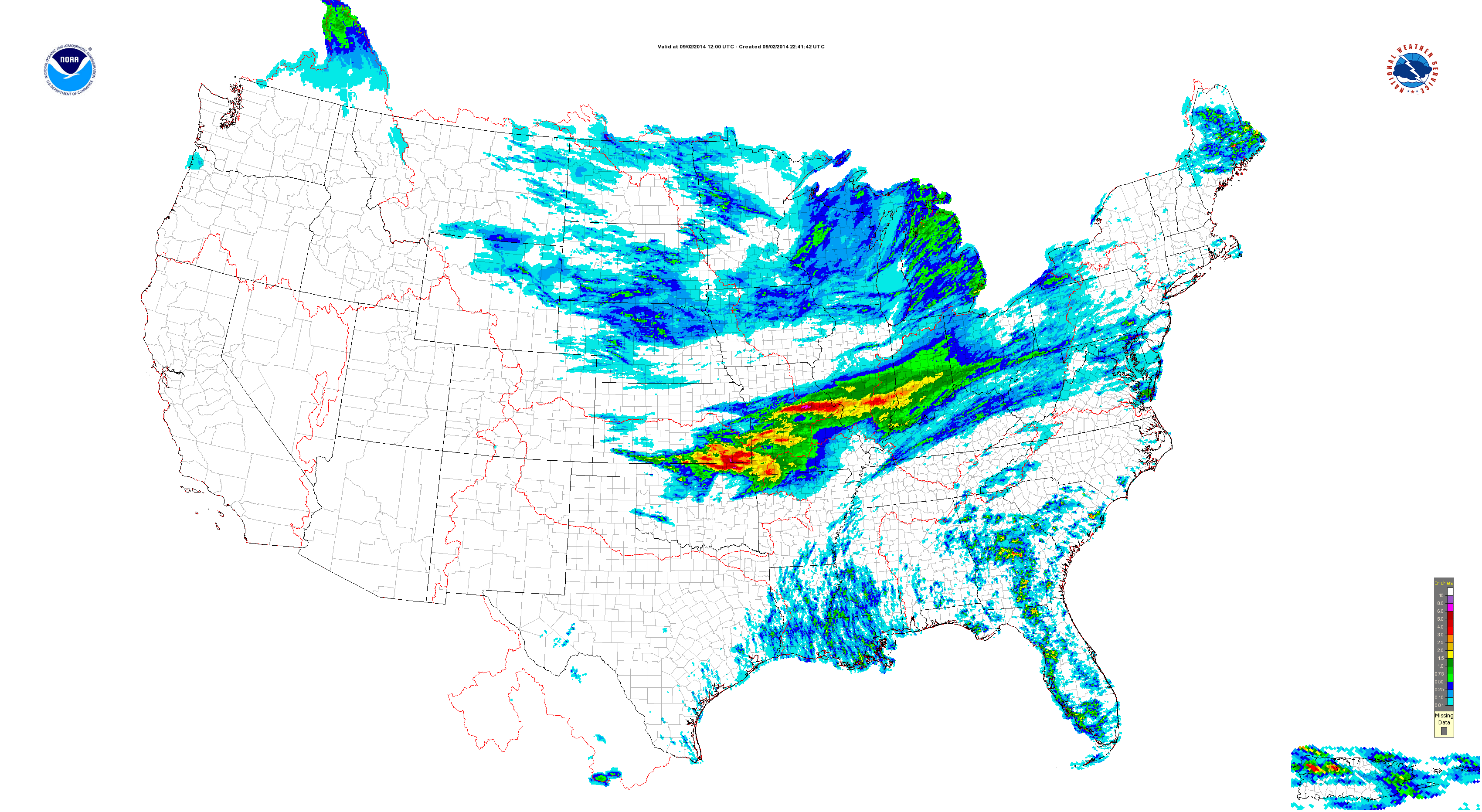
conus_precip-composite_hi_res

Moving forward, the pattern over the upcoming (2) weeks appears wetter than normal.

In the shorter term, the GFS and Canadian paint a wet picture out by Days 7-10 (BTW- the European agrees).
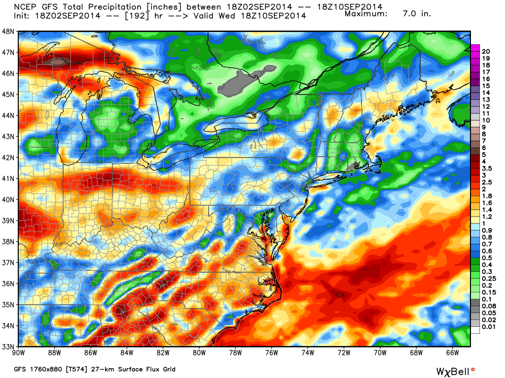
gfs_tprecip_ma_65


cmc_total_precip_ma_41

Modeling suggests 2-3″ type rainfall is possible over the upcoming 7-10 day period.  A transient pattern can be thanked for the overall wet forecast.

The CFSv2 also suggests precipitation runs 150%-200% of normal levels through mid September.
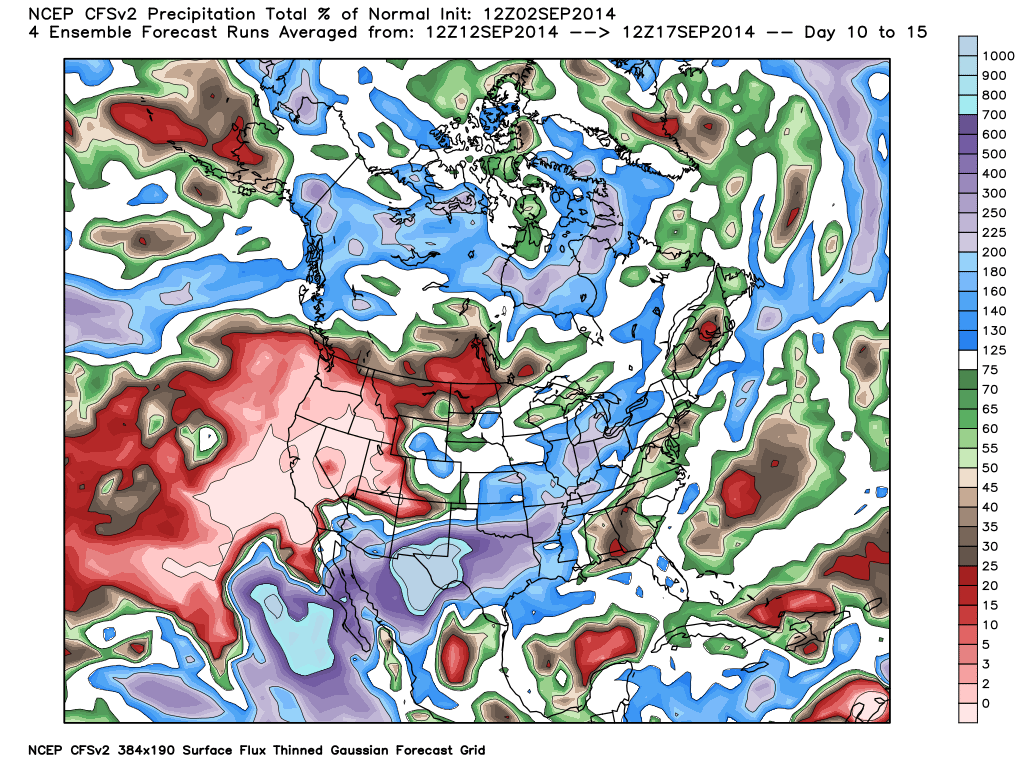
cfs_tprecip_anom_noram_2014090212_61

As harvest begins across some Hoosier farm lands, note the increased wetness in the pattern through the upcoming 14 days, or so.

The region will remain in an active pattern through the next couple weeks, at least, as we lie in the battle ground between a stubborn southeastern ridge and an increasingly active early fall northern stream.  A wetter than normal mid west will ensue…

Improving Weather Through The Day…

Tue.

Wed.

Thr.

Fri.

Sat.

Sun.

Mon.

 Status-weather-showers-day-icon

 Status-weather-clouds-icon

 Status-weather-clouds-icon

 Status-weather-showers-day-icon

 Status-weather-clouds-icon

 Status-weather-clouds-icon

 Status-weather-clouds-icon

67/ 80

60/ 83

64/ 87

69/ 89

55/ 73

49/ 73

51/ 76 

Decreasing Rain Coverage; Increasing Sunshine…A shield of moderate to heavy rain encompassed the state during the overnight.  This shield of rain is slowly moving east, southeast and we’ll be looking at improving weather through the day.  There’s still the chance of a widely scattered thunderstorm late morning or early afternoon as a frontal boundary slides through the region.

Sunny Days…As we progress through the mid and late week stretch, we’ll enjoy dry skies and plentiful sunshine.  Normal lows and highs are in the lower 60s and lower 80s this time of year, so we’ll be very close to that Wednesday before moderating temperatures take us warmer than average to wrap up the work week.

Late Week Cold Front; Autumn Feel This Weekend…A cold front will slice into the warm and humid air mass Friday evening and lead to the possibility of a broken line of strong to potentially severe thunderstorms.  A MUCH cooler air mass will then invade the region behind the boundary, leading to a true fall-like feel this weekend!

7-Day Precipitation Forecast:

  • 7-Day Rainfall Forecast:  0.50″ – 0.75″
  • 7-Day Snowfall Forecast: 0.00″

John Salewicz sent us this beautiful sunrise photo Saturday morning before storms invaded portions of central Indiana.  Thanks, John!

BwSIn32CIAAqYL7


Are you craving cooler air to go along with that early season pumpkin spice latte? You'll be in luck this weekend as a true fall-like air mass invades...
Are you craving cooler air to go along with that early season pumpkin spice latte? You’ll be in luck this weekend as a true fall-like air mass invades…

Muggy And Potentially Stormy IndySportsReport.com Football Forecast

Good morning football fans! Your IndySportsReport.com high school football forecast promises to be a warm and humid one with storm potential… A warm front will lift north through the region…

You must be logged in to view this content. Click Here to become a member of IndyWX.com for full access.  Already a member of IndyWx.com All-Access?  Log-in here.