Category: Forecast Models

Thursday Evening Update…

Rain chances continue to look less and less impressive tomorrow morning.  All-in-all, similar to last weekend, we’re expecting a beautiful time of things across the region going into the Easter…

You must be logged in to view this content. Click Here to become a member of IndyWX.com for full access.  Already a member of IndyWx.com All-Access?  Log-in here.

Permanent link to this article: https://indywx.com/thursday-evening-update/

Old Man Winter Isn’t Finished

Come this afternoon it’ll be tough to believe we were in the 70s over the weekend!  A cold front is moving through central Indiana this morning and resulting in showers.  Rain will continue in an off-and-on fashion today, becoming a bit more organized yet again later this afternoon and evening.  This will be in response to a wave of low pressure developing to our east, along the pressing strong cold front.

A look at the forecast simulated radar at 7pm this evening:

1

MUCH colder air will pour into the region today, complete with gusty northwest winds.  In fact, we’ll be in the 40s just after the lunchtime hour and the free-fall will continue.  30s arrive this evening and rain will begin to transition to wet snow.  Not all will see accumulation tonight, but a slushy accumulation of around half an inch will be possible where heavier snow persists.

A look at the forecast simulated radar towards 11pm-12am:

23

Temperatures will crash into the 20s by Tuesday morning.  I saw many folks at Lowes buying flowers yesterday…hopefully those folks aren’t planning on planting until later…

4

Tuesday will feature clearing skies, albeit unseasonably cold conditions.  We’ll remain in the 30s most of Tuesday, struggling to make it much above 40 by afternoon, along with a chilly northwest wind in place.  Lows Tuesday night/ Wednesday morning will drop into the lower to middle 20s.

Permanent link to this article: https://indywx.com/old-man-winter-isnt-finished/

Taste Of True Spring Coming, But Another Shot Of Winter On Deck…

Wed.

Thr.

Fri.

Sat.

Sun.

Mon.

Tue.

 Status-weather-clouds-icon

 Status-weather-clouds-icon

 Status-weather-showers-day-icon

 Status-weather-clouds-icon

 Status-weather-storm-night-icon

 Status-weather-showers-scattered-icon

 Status-weather-snow-scattered-day-icon

36/ 58

44/ 70

49/ 63

43/ 70

56/ 68

39/ 56

28/ 40

– – –

– – –

Light

– – –

Light

Moderate

– – –

Custom IndyWx.com Forecast Updated 04.09.14 @ 8:31a

Sunshine Returns; Warming Up. . .Instability-driven thundershowers developed Tuesday afternoon across central Indiana and even produced small hail in a few locations, especially east of the city.  Thankfully though the sunshine we experienced Tuesday evening is a sign of things to come for the mid week stretch.  We forecast a mostly sunny to partly cloudy sky both today and Thursday, along with moderating temperatures.

A strong southwest breeze will help usher in potentially the first 70 degree day of the year Thursday.  We also note winds may gust upwards of 30 MPH (especially in the open country) Thursday afternoon.

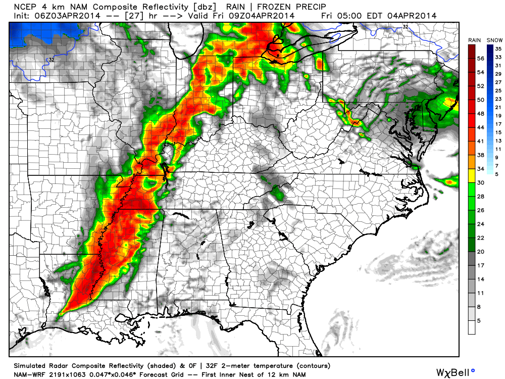
Late Week Front. . .A cold front will move through the region during the day Friday.  Latest model data suggests a little more moisture will be available than we thought earlier this week and as a result we’ll hit the shower and potential thundershower chance a little harder Friday.  Anywhere from 0.25-0.50 of rain will be possible with this system as it moves through the area.

Watching The Weekend. . .While Friday’s front will only make it so far south, we’re still thinking Saturday will be rain-free for the majority of central Indiana.  We’ll note the threat of a shower down state and keep a close eye on things, but for now we’ll keep Saturday’s forecast dry and warm.  Get out there and enjoy a beautiful day!

Our next storm system will take aim on the region Sunday.  As such, clouds will increase and shower and thunderstorm chances will be on the rise as we go through the day.  We do note a rather large range in model forecast temperatures Sunday between the middle 70s per the European data to the lower 60s per the GFS.  For now, we’ll split the difference and forecast upper 60s Sunday with increasing rain chances as we progress through the day.  Stay tuned.

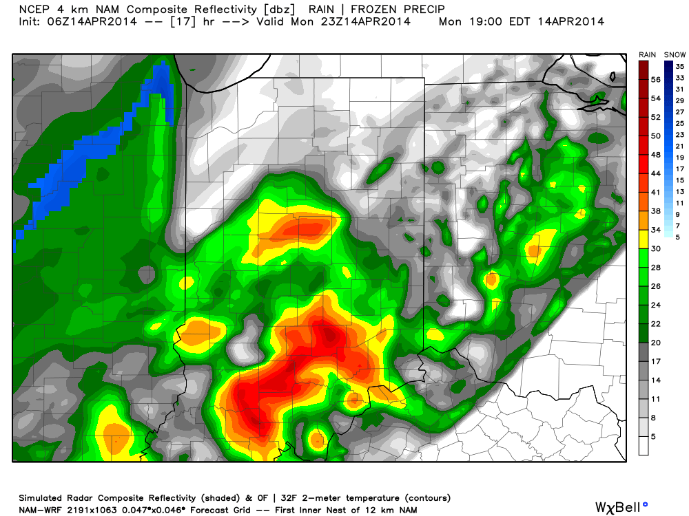
Brief, But Potent Blast Of Winter Chill. . .Another significant rain maker will blow through the region Sunday night into Monday.  At this early stage in the game, there’s a rather high probability of moderate to heavy rainfall (greater than 1″), but the bigger story will likely be the blast of winter-like chill that will invade next Monday night into Tuesday.  In fact, there may be just enough moisture lingering to result in some light snow or flurries Tuesday as the cold air pours in.

Upcoming 7-Day Precipitation Forecast:

  • 7-Day Rainfall Forecast: 1″ – 1.5″
  • 7-Day Snowfall Forecast: 0.00″

twicFor weather updates and more “behind the scenes” data on the go, be sure to Follow Us on Twitter @indywx or become a Friend of IndyWx.com on Facebook!

images

Permanent link to this article: https://indywx.com/taste-of-true-spring-coming-but-another-shot-of-winter-on-deck/

Looking At Tonight’s Weather And Another Storm Monday…

Good evening.  It’s been a busy day across central Indiana and we’re not finished just yet.  While the heaviest rains and strong to severe thunderstorms targets southern parts of the…

You must be logged in to view this content. Click Here to become a member of IndyWX.com for full access.  Already a member of IndyWx.com All-Access?  Log-in here.

Permanent link to this article: https://indywx.com/looking-at-tonights-weather-and-another-storm-monday/

Update On The Heavy Rain And Severe Potential

It’s a wet and stormy morning across central Indiana, including heavy rain and embedded stronger storms.  The latest HRRR short-term data paints a continued stormy picture through the morning.

hrrr_ref_indy_7

That said, we’ll get into some dry time late morning into the afternoon, but the atmosphere will be priming itself for another noisy night ahead.  The Storm Prediction Center (SPC) outlines the region under a slight risk of severe weather, including damaging wind, damaging hail, and a potential tornado.  The greatest risk of severe is to our south, but we must remain on our toes tonight into the wee morning hours Friday.  Please keep your weather radios on alert mode tonight.

3

The simulated radar shows thunderstorms re-firing to our west late tonight, moving in during the overnight hours.

12

When all is said and done (and accounting Wednesday’s rain) we still forecast widespread 2-3″ of rain across the region, with locally heavier totals.  Additionally, we bracket late tonight into the early Friday morning hours for the greatest chance of severe weather across our region.  Hail and straight line wind damage are of the greatest concerns, but a tornado can’t be ruled out.  The cold front will sweep the state clean Friday afternoon and help set up a very nice, although cooler, weekend.

Permanent link to this article: https://indywx.com/update-on-the-heavy-rain-and-severe-potential/