Category: Forecast Models

Two Rounds Of Storms Ahead.

Good evening friends!  I hope this finds you having a nice Wednesday.  Our video update this evening looks at a couple rounds of strong, to potentially severe, thunderstorms ahead.

You must be logged in to view this content. Click Here to become a member of IndyWX.com for full access.  Already a member of IndyWx.com All-Access?  Log-in here.

Permanent link to this article: https://indywx.com/two-rounds-of-storms-ahead/

Nighttime Thunder…

Wed.

Thr.

Fri.

Sat.

Sun.

Mon.

Tue.

 Status-weather-showers-day-icon

 Status-weather-showers-day-icon

 Status-weather-showers-day-icon

 Status-weather-clouds-icon

 Status-weather-showers-day-icon

 Status-weather-showers-day-icon

 Status-weather-storm-night-icon

71/ 89

70/ 88

70/ 87

69/ 86

62/ 84

66/ 89

70/ 82 

Light

Light

Light

– – –

Light

Light

Moderate

An unsettled and overall active weather pattern will remain in place over the upcoming forecast period.  While it certainly won’t rain and storm the duration of the next seven days, we’ll have to focus in on individual disturbances and the associated impacts on our immediate region as we move forward.  The Storm Prediction Center does include the majority of central Indiana in a Slight Risk of severe weather this afternoon and tonight, with damaging straight line winds the primary concern.  All of that said, we also must point out that some of our short term model data is trending east with the thunderstorm activity tonight, primarily impacting eastern Indiana into Ohio.  We’ll monitor things closely and have another update on a potential storm track and timing this evening.  Stay tuned.  Widespread seven day rainfall numbers off an average of computer models would place 1.5″-2″ down across central Indiana.

Permanent link to this article: https://indywx.com/nighttime-thunder/

Still Anticipate Late June Changes…

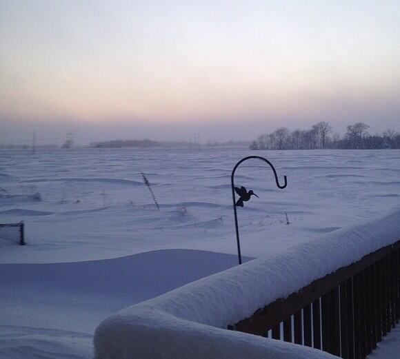
We asked this question on our Twitter account earlier this morning.  Do you prefer heat and humidity or frigid and snowy?  Here’s a look out the back door from the IndyWx.com HQ from this morning and then back to right after the early January winter storm.  Note the snow depth on the fence line.  Amazing stuff!

BqVrtazCQAAKGVy.jpg-largeBqVrtMxCYAA-OdA.jpg-large


Anyway…as we look ahead, we still anticipate an overall regime change as we progress through the upcoming weekend and into next week.

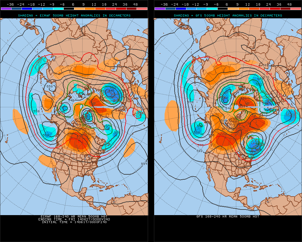
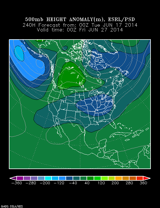
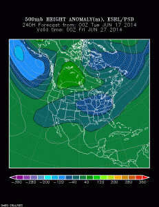
Model data remains in rather good agreement on the evolution of the upper air pattern over the course of the upcoming 7-10 day period.  The GFS is a touch more aggressive on the eastern trough when compared to the European, but both agree on week 2 cooling, as do we.

test8


This won’t be tremendously cool air (such as last weekend), but when compared to averages, we’re likely to cool things back to slightly below normal.

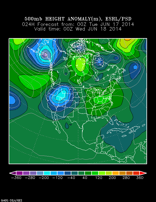
The PSD shows the changes, as well.  Note the current eastern ridge is replaced by the Day 10 eastern trough.

z500_anom_f024_ussmz500_anom_f240_ussm


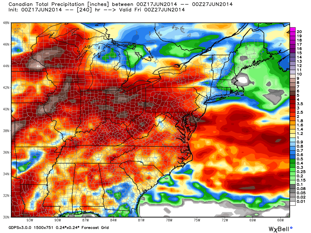
The precipitation idea is one that is continued wet.  Our three primary mid range global models (GFS, Canadian, Euro) agree on widespread rainfall totals of 1.5″-3″ (locally heavier totals where stronger thunderstorms move) over the next 10 days.  Here’s a closer look at the Canadian, thanks to the model suite at Weatherbell Analytics.

cmc_total_precip_ma_41

Permanent link to this article: https://indywx.com/still-anticipate-late-june-changes/

Monday Evening Video Update; Feeling Very Much Like Summer…

Quick video update tonight discusses some of our thoughts as we progress through the week ahead!

You must be logged in to view this content. Click Here to become a member of IndyWX.com for full access.  Already a member of IndyWx.com All-Access?  Log-in here.

Permanent link to this article: https://indywx.com/monday-evening-video-update-feeling-very-much-like-summer/

Monday Morning Weather Rambles…

Walking out the door this morning feels dramatically different than what we’ve enjoyed over the weekend!  Not only are humidity levels much higher, but temperatures are 15-20 degrees warmer than what they were this time 24 hours ago across the Ohio Valley and Great Lakes.

t0

With the increased warmth and humidity, it’s not going to take much to kick scattered showers and thunderstorms off.  That’s exactly what we’re seeing across central Indiana this morning.  Locally heavy downpours are possible under any of the stronger storms.

Look at the Northeast region radar snapped at 8am, courtesy of the Penn State e-wall site:

nerad25

As for precipitation amounts, it still appears as if we’re in a wetter than normal regime over the next couple weeks.  As of this morning, we’re officially running 1.56″ above normal at IND year-to-date.  A look over a blend of GFS, Euro, and Canadian would imply widespread 2-3″ amounts over the upcoming two weeks, with locally heavier totals where local downpours occur.  This is NOT what one wanting a hot pattern to lock in wants to hear.

While warmth and humidity will be the story this week, we still think we turn cooler to wrap up June.  We’ve been talking about a cooler than normal pattern developing for late month and latest guidance continues to suggest that thinking has merit.  Much more later!  BTW- your 7-day forecast can be found here.

Geopotential32at32500hPa_North32America_240wk1.wk2_20140615.NAsfcT z500_anom_f192_ussm

Permanent link to this article: https://indywx.com/monday-morning-weather-rambles-2/