Thursday Weather Notebook…

Wow, what a difference 24 hours can make! If you haven’t stepped outside yet this morning you’ll certainly notice the cooler, drier, and almost fall feel to the air upon…

You must be logged in to view this content. Click Here to become a member of IndyWX.com for full access.  Already a member of IndyWx.com All-Access?  Log-in here.

Wednesday Weather Notebook; Strong Storms Still Possible…

A significant late summer cold front will move into the warm and humid air mass currently in place later tonight. This time tomorrow will feel mighty different outside with a…

You must be logged in to view this content. Click Here to become a member of IndyWX.com for full access.  Already a member of IndyWx.com All-Access?  Log-in here.

Tuesday Weather Notebook

*We’re going to begin posting a discussion going into more detail around the what and why of the seven day forecast in the mornings, followed by the actual updated 7-day…

You must be logged in to view this content. Click Here to become a member of IndyWX.com for full access.  Already a member of IndyWx.com All-Access?  Log-in here.

Monday Weather Notebook…

*We’re going to begin posting a discussion going into more detail around the what and why of the seven day forecast in the mornings, followed by the actual updated 7-day…

You must be logged in to view this content. Click Here to become a member of IndyWX.com for full access.  Already a member of IndyWx.com All-Access?  Log-in here.

Keeping An Eye On Mid Week Storms…

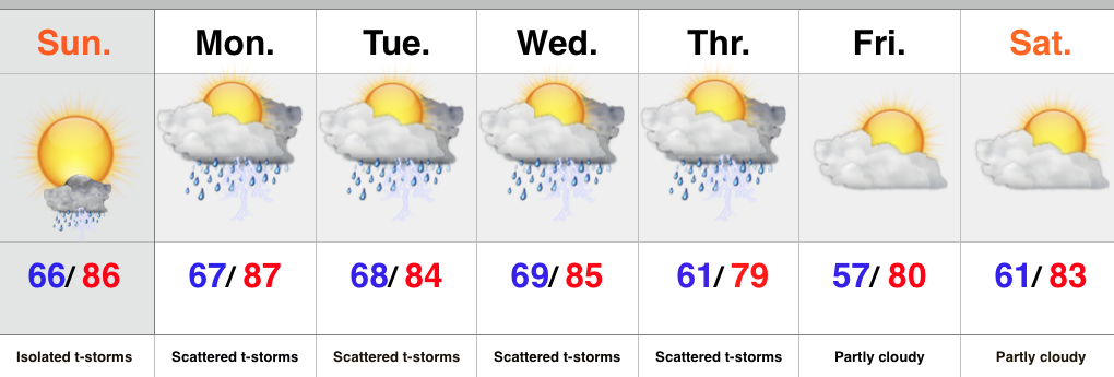
Screen Shot 2015-08-15 at 9.24.02 PMHighlights:

  • Warm and humid
  • Midweek storms may reach strong to severe levels
  • Late week model differences

The second half of the weekend will feature plenty of warmth and humidity, but should be mainly dry.  We’ll include mention of an isolated storm.  Better coverage of showers and thunderstorms will return to our forecast through the early week period and we’ll continue to keep a close eye on the potential of strong to severe thunderstorms Wednesday into Thursday.  Stay tuned.

As we look forward, there’s some disagreement with the evolution of things from mid to late week.  The GFS is more progressive and delivers drier, cooler air to wrap up the week, while the European is a bit more sluggish.  We’ll go with a blend for now, leaning more towards the GFS solution.

Upcoming 7-Day Rainfall Forecast: 1″ – 1.5″