
You must be logged in to view this content. Click Here to become a member of IndyWX.com for full access. Already a member of IndyWx.com All-Access? Log-in here.
Category: Forecast Models
Permanent link to this article: https://indywx.com/video-winter-arrives-next-week/
Nov 27
Warmth Dominates Now, But A Cold & Wintry Pattern Is Lurking For The Holidays…
The short-term weather pattern will continue to be dominated by rather “boring” conditions for this time of year, along with much milder than normal air. A weak frontal system will swing through here Thursday and while a light shower is possible, that’s really the only significant (if you want to call it that) weather feature through the upcoming 7-10 days.
In addition to the rather quiet weather, relative warmth will dominate as we open December. When “normals” feature lows in the upper 20s and highs in the lower 40s, actual overnight lows will only fall into the low-mid 30s and highs will reach the middle to upper 50s.
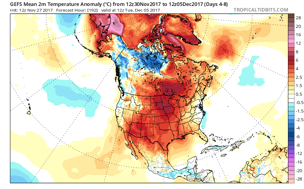 When we look ahead, the shelf life of this warmth is certainly limited. The GEFS showcases this shift in the pattern from a warm open to the month towards a much colder pattern very nicely. The GEFS has other model support, as well.
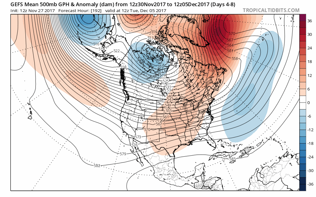 This is the type of dramatic shift in the overall pattern that not only threatens to “lock in” a colder than average regime, but potentially lead to plenty of wintry mischief to boot, and just in time for the holiday season.
There’s teleconnection support for the wintry shift, as well, leading to further confidence of a significant move towards cold, and potentially snowy/ icy, conditions as the true holiday and Christmas season approaches.
 To summarize, while unseasonably quiet and mild conditions will rule in the short-term, Mother Nature sure seems to have an attitude of making up for “lost time” in the medium to longer range. This is the type pattern that we’ll have to monitor the potential of some sort of leader-follower scenario as the transition from warm to cold takes place, and given the blocky nature of the pattern, it sure seems like we’re heading into a busy time of things from a wintry perspective mid and late month.
Perhaps this will be the scene as Christmas time nears across the Mid West, including central Indiana? Time will tell…

Permanent link to this article: https://indywx.com/warmth-dominates-now-but-a-cold-wintry-pattern-is-lurking-for-the-holidays/
Nov 26
VIDEO: Early-December Warmth Won’t Last…
You must be logged in to view this content. Click Here to become a member of IndyWX.com for full access. Already a member of IndyWx.com All-Access? Log-in here.
Permanent link to this article: https://indywx.com/video-early-december-warmth-wont-last/
Nov 23
VIDEO: Happy Thanksgiving; Early December Chatter…
First and foremost, from our family to yours, we wish you a blessed Thanksgiving. Enjoy the day with loved ones, eat a ton, and ensure you get a little football…
You must be logged in to view this content. Click Here to become a member of IndyWX.com for full access. Already a member of IndyWx.com All-Access? Log-in here.
Permanent link to this article: https://indywx.com/video-happy-thanksgiving-early-december-chatter/
Nov 20
Extended Stretch Of Unusually Quiet Weather…
High pressure will remain in control of our weather as we open the short Thanksgiving week. This will supply plentiful sunshine today, along with an increasingly gusty southwest wind by this afternoon (30 MPH). A cold start (most in the middle 20s) will moderate to near seasonal norms by this afternoon (upper 40s to around 50).

A tightening pressure gradient will result in gusty winds this afternoon.
Reinforcing chilly air will blow into town Tuesday night. Ahead of this, weak moisture return will lead to a few showers Tuesday afternoon. Winds will shift to the northwest Tuesday night and help push a colder air mass into the state. This colder than average theme will continue for Thanksgiving Day, itself. Highs in the lower 40s Wednesday and Thursday can be expected with lows in the middle to upper 20s. Dry weather will quickly return Wednesday and Thursday.
A few light showers will move into town Tuesday afternoon.
Finally, another weak weather maker will approach late Black Friday into the holiday weekend. This cold front will be enough to generate showers Saturday and will help push another shot of chill into the area as we close the weekend. Similar to Tuesday afternoon’s rain, amounts will be very light. In fact, total rainfall with both systems should fall in the 0.10″-0.25″ range.

Permanent link to this article: https://indywx.com/extended-stretch-of-unusually-quiet-weather/